Difference between revisions of "2015-03-18 52 21"
From Geohashing
imported>Norill (Created page with "{{subst:Expedition |lat = 52 |lon = 21 |date = 2015-03-18 }}") |
m (Replacing tracklog = File:2015-03-18 52 21 2.jpg with tracklog = {{canonicalurl:File:2015-03-18 52 21 2.jpg}}) |
||
| (6 intermediate revisions by 4 users not shown) | |||
| Line 19: | Line 19: | ||
== Location == | == Location == | ||
<!-- where you've surveyed the hash to be --> | <!-- where you've surveyed the hash to be --> | ||
| + | A field in Nowa Iwiczna. | ||
== Participants == | == Participants == | ||
<!-- who attended: If you link to your wiki user name in this section, your expedition will be picked up by the various statistics generated for geohashing. You may use three tildes ~ as a shortcut to automatically insert the user signature of the account you are editing with. | <!-- who attended: If you link to your wiki user name in this section, your expedition will be picked up by the various statistics generated for geohashing. You may use three tildes ~ as a shortcut to automatically insert the user signature of the account you are editing with. | ||
--> | --> | ||
| + | *[[User:Norill|Norill]] | ||
| + | *[[User:Ziemba|Ziemba]] | ||
== Plans == | == Plans == | ||
<!-- what were the original plans --> | <!-- what were the original plans --> | ||
| + | Norill noticed the hash is 700m from his apartment on the previous day. He went to the coordinates to scout the area (1st visit). | ||
== Expedition == | == Expedition == | ||
<!-- how it all turned out. your narrative goes here. --> | <!-- how it all turned out. your narrative goes here. --> | ||
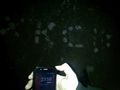
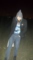
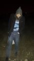
| + | Norill reaches the site alone on midnight between March 17 and 18 and makes the XKCD marker (w/o GPS). Next day we went together, visited a market on the way and had poor man's picnic on the site (not good enough for an achievement). | ||
== Tracklog == | == Tracklog == | ||
<!-- if your GPS device keeps a log, you may post a link here --> | <!-- if your GPS device keeps a log, you may post a link here --> | ||
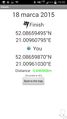
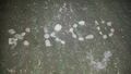
| + | [[Image:2015-03-18 52 21 2.jpg|400px]] | ||
| + | |||
| + | TRON TOILET THRONE | ||
| + | |||
| + | |||
== Photos == | == Photos == | ||
| Line 37: | Line 47: | ||
Image:2012-##-## ## ## Alpha.jpg | Witty Comment | Image:2012-##-## ## ## Alpha.jpg | Witty Comment | ||
--> | --> | ||
| + | === First expedition === | ||
<gallery perrow="5"> | <gallery perrow="5"> | ||
| + | Image:Zdjęcie0712.jpg | marker | ||
| + | Image:Zdjęcie0714.jpg | | ||
| + | Image:Zdjęcie0717.jpg | Prestige tower and church | ||
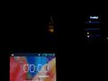
| + | Image:Zdjęcie0718.jpg | 00:00 2015-03-18 | ||
| + | </gallery> | ||
| + | === Second expedition === | ||
| + | <gallery perrow="5"> | ||
| + | Image:2015-03-18 52 21 1.jpg | map view | ||
| + | Image:2015-03-18 52 21 7.jpg | coordinate view | ||
| + | Image:2015-03-18 52 21 3.jpg | om nom | ||
| + | Image:2015-03-18 52 21 4.jpg | | ||
| + | Image:2015-03-18 52 21 5.jpg | Prestige tower | ||
| + | Image:2015-03-18 52 21 6.jpg | XKCD | ||
| + | Image:2015-03-18 52 21 8.jpg | | ||
| + | Image:2015-03-18 52 21 9.jpg | | ||
| + | Image:2015-03-18 52 21 10.jpg | | ||
| + | Image:2015-03-18 52 21 11.jpg | | ||
</gallery> | </gallery> | ||
| Line 43: | Line 71: | ||
{{#vardefine:ribbonwidth|800px}} | {{#vardefine:ribbonwidth|800px}} | ||
<!-- Add any achievement ribbons you earned below, or remove this section --> | <!-- Add any achievement ribbons you earned below, or remove this section --> | ||
| + | {{couch potato geohash | ||
| + | | latitude = 52 | ||
| + | | longitude = 21 | ||
| + | | date = 2015-03-18 | ||
| + | | name = [[User:Norill|Norill]] | ||
| + | | honor = true | ||
| + | }} | ||
| + | {{No_batteries_geohash | ||
| + | | latitude = 52 | ||
| + | | longitude = 21 | ||
| + | | date = 2015-03-18 | ||
| + | | name = [[User:Norill|Norill]] | ||
| + | }} | ||
| − | + | {{Midnight geohash | |
| − | + | | latitude = 52 | |
| − | [[ | + | | longitude = 21 |
| + | | date = 2015-03-18 | ||
| + | | name = [[User:Norill|Norill]] | ||
| + | }} | ||
| − | + | {{Walk geohash | |
| + | | latitude = 52 | ||
| + | | longitude = 21 | ||
| + | | date = 2015-03-18 | ||
| + | | name = [[User:Norill|Norill]] | ||
| + | | distance = 3840m | ||
| + | }} | ||
| − | |||
| − | |||
| − | |||
| − | |||
| − | + | {{bicycle geohash | |
| − | [[ | + | | latitude = 52 |
| − | -- | + | | longitude = 21 |
| − | [[ | + | | date = 2015-03-18 |
| − | [[ | + | | name = [[User:Ziemba|Ziemba]] |
| − | + | | distance = 14km | |
| − | -- | + | | bothways = true |
| − | + | }} | |
| − | + | ||
| − | + | {{Tron | |
| + | | latitude = 52 | ||
| + | | longitude = 21 | ||
| + | | date = 2015-03-18 | ||
| + | | possessive = their | ||
| + | | tracklog = {{canonicalurl:File:2015-03-18 52 21 2.jpg}} | ||
| + | | name = [[User:Norill|Norill]] and [[User:Ziemba|Ziemba]] | ||
| + | | image = 2015-03-18_52_21_2.jpg | ||
| + | }} | ||
| − | + | [[Category:Expeditions]] | |
| − | [[Category: | + | [[Category:Expeditions with photos]] |
| − | |||
| − | |||
| − | |||
| − | |||
| − | |||
| − | [[Category: | ||
| − | + | [[Category:Expedition without GPS]] | |
| − | [[Category: | ||
| − | |||
| − | |||
| − | |||
| − | + | [[Category:Coordinates reached]] | |
| + | {{location|PL|W|PI}} | ||
Latest revision as of 11:51, 19 February 2020
| Wed 18 Mar 2015 in 52,21: 52.0865950, 21.0096080 geohashing.info google osm bing/os kml crox |
Location
A field in Nowa Iwiczna.
Participants
Plans
Norill noticed the hash is 700m from his apartment on the previous day. He went to the coordinates to scout the area (1st visit).
Expedition
Norill reaches the site alone on midnight between March 17 and 18 and makes the XKCD marker (w/o GPS). Next day we went together, visited a market on the way and had poor man's picnic on the site (not good enough for an achievement).
Tracklog

TRON TOILET THRONE
Photos
First expedition
marker

Prestige tower and church
00:00 2015-03-18


Second expedition
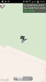
map view
coordinate view
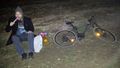
om nom
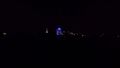
Prestige tower
XKCD


Achievements

Norill earned the Couch Potato Geohash Honorable Mention
by living near the (52, 21) geohash on 2015-03-18.
Norill earned the No Batteries Geohash Achievement
|
Norill earned the Midnight Geohash achievement
|
Norill earned the Walk geohash Achievement
|
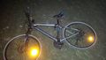
Ziemba earned the Bicycle geohash achievement
|
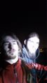
Norill and Ziemba earned the Tron achievement
|
Categories:
- Meetup on 2015-03-18
- Meetup in 52 21
- Couch potato geohash honorable mention
- No batteries geohash achievement
- Midnight geohash achievement
- Walk geohash achievement
- Bicycle geohash achievement
- Tron achievement
- Expeditions
- Expeditions with photos
- Expedition without GPS
- Coordinates reached
- Meetup in powiat piaseczyński