Difference between revisions of "2015-03-22 -27 153"
imported>Felix Dance m |
m (More specific location) |
||
| (2 intermediate revisions by 2 users not shown) | |||
| Line 79: | Line 79: | ||
| image = Geohash 2015-03-22 -27 153 03 Groupshot.JPG | | image = Geohash 2015-03-22 -27 153 03 Groupshot.JPG | ||
}} | }} | ||
| − | |||
| − | |||
| − | |||
| − | |||
| − | |||
| − | |||
| − | |||
| − | |||
| − | |||
| − | |||
| − | |||
[[Category:Expeditions]] | [[Category:Expeditions]] | ||
[[Category:Expeditions with photos]] | [[Category:Expeditions with photos]] | ||
[[Category:Coordinates reached]] | [[Category:Coordinates reached]] | ||
| − | + | {{location|AU|QLD|MB}} | |
| − | |||
| − | |||
| − | |||
| − | |||
| − | |||
| − | |||
| − | |||
| − | |||
| − | |||
| − | |||
| − | |||
| − | |||
| − | |||
| − | |||
| − | |||
| − | |||
Latest revision as of 19:08, 28 September 2020
| Sun 22 Mar 2015 in -27,153: -27.0718751, 153.1057869 geohashing.info google osm bing/os kml crox |
Location
On a residential street corner in Ningi, north of Brisbane
Participants
- Felix Dance
- Liz
- Tim
- Bec
- Patrick
- Kathryn
Expedition
- First hash -- Pdiddy (talk) @-27.0719,153.1058 18:28, 22 March 2015 (GMT+10:00)
- 5m away, so close to my first geohash! -- Kathryngw (talk) @-27.0719,153.1058 04:31, 22 March 2015 (EDT)
- Got it :) -- Kathryngw (talk) @-27.0719,153.1058 04:32, 22 March 2015 (EDT)
So, I'd been down to Brisbane from Darwin to visit some of my buddies living there now. Mandatorily, this involved checking where the geohashes were, particularly since I'd just missed out on an awesome one near Darwin I could've got to had I been up that way. And sure enough, there was one not too far off the path of where we had planned to go walking that day.
After the walk up one of the Glasshouse Mountains, I think it was Ngun Ngun or something, with buddies Tim, Bec, Liz, Katheryn and Patrick, we drove in two cars towards the hash area. The rain poured down, as it always does when I'm in Brisbane, and we both stupidly missed the turn-off. But doubling back and heading into the bland, soul destroying urban sprawl of Northern Brisbane we quickly rounded on the hash point. Since my usual app was no longer working, I had to force everyone to stand around in the rain looking at baby cane toads while I made sure we really were at the right spot, and eventually I decided, 'Good enough' so we left.
After a swim and beer on Bribie Island, Katheryn and Patrick got excited with their new Android Geohashing app so we decided, much to Tim's annoyance, to swing by the hash again so they could register it on their new accounts. By this time it was dark, and still raining. Plus, there were residents in the house just behind the hash watching TV and wondering why their dog was so barky. With some frustration we waited around in the bushes until both phones told us we were within 2m of the hash, declared success and went back to Brisbane, where all of us except Liz ate Indian Takeaway at a bar in West End.
Tracklog
Here is the route of our trip.
Photos
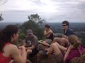
Glasshouse Mountains prior to hash
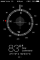
GPS Proof
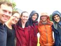
The group at the hash
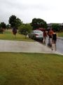
Escaping from the rain
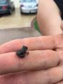
Cane Toad
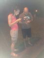
Rehash after the beach


Achievements
This user earned the Drag-along achievement
|