Difference between revisions of "2015-03-24 47 -122"
imported>Thomcat (Do you know what is located at 51.42774907, 5.35204802 ?) |
imported>FippeBot m (Location) |
||
| (11 intermediate revisions by one other user not shown) | |||
| Line 1: | Line 1: | ||
{{meetup graticule | {{meetup graticule | ||
| − | | lat= | + | | lat=47 |
| − | | lon= | + | | lon=-122 |
| − | | date=2015-03- | + | | date=2015-03-24 |
| − | | graticule_name= | + | | graticule_name=Seattle |
| − | | graticule_link= | + | | graticule_link=Seattle, Washington |
}} | }} | ||
__NOTOC__ | __NOTOC__ | ||
== Location == | == Location == | ||
| − | On | + | On the southern border of Yost Memorial Park. |
== Participants == | == Participants == | ||
| Line 15: | Line 15: | ||
== Plans == | == Plans == | ||
| − | + | On the southern border of Yost Memorial Park; likely on private property. Will examine on the way home from work today. | |
== Expedition == | == Expedition == | ||
| − | + | The initial investigation showed this to be close to the fence between a house and the park. Depending on access to said house (one aerial photo showed the point to be in a driveway), this may or may not work out. My other hope was based on this drawing, or specifically, the path in the lower right hand corner. | |
| + | [http://1.bp.blogspot.com/-nsXWgJ_x4kY/Tt7KsgY-mrI/AAAAAAAABVg/xqQ3OPJZaNY/s1600/Yost+Trail+Map.jpg Yost Trail Map] | ||
| + | |||
| + | Aerial photos and maps showed this to be relatively flat, though the trail mentioned above was labeled the "overlook trail". Was there a ravine, an unmarked pit, or what? I fortified myself before the visit with a Dick's Milkshake. | ||
| + | |||
| + | I reached the street that appeared to lead to this one and found no access. The next street over was much better. I proceeded down a steep hill and turned into what looked to be a private drive - though it was not labeled as such. This led to two houses, one being the house in question. Leading to the hashpoint was indeed a driveway... and a garage or large shed which was not pictured on the original photo. The yard was also fenced off, with what looked to be chicken mesh. No poultry were in evidence. I snapped a quick photo from 12 meters away, left the Crox poster, and departed. | ||
| + | |||
| + | The next road to the east led to a park trail entrance, according to some maps I read. I drove down another very steep road and found a gate forbidding vehicle traffic. Just beyond was a trail leading up the hill - the "overlook trail" from the map. I parked and hiked. | ||
| + | |||
| + | The hill was very steep, but I persevered to the top. At that point, the trail did branch to the left, as per the drawing. GPS told me I was getting close - could this be the ticket? I continued down the trail and found... a trail exit, right at the end of the first road I took. I didn't see this trail from the car! | ||
| + | |||
| + | Back from that exit was a little side trail, somewhat overgrown. It led in the direction of the point - could it work for me? I followed it and came to... another exit. This time a gate to the back yard of the house at the end of the first street. GPS said I was less than 20 meters away, though the photo says 22. So close! | ||
| + | |||
| + | From that was another overgrown part, but it was clear enough to walk. Braving the thorns and undergrowth, I headed more or less straight east from the previous point. There, in front of me, was the yard I had pictured from the other end. With less than 5 meters to go, I proceeded down the hill and reached with 0.7 meters of the spot. Success! | ||
| + | |||
| + | (I note that the coordinates tacked on to the picture captions are exactly correct, even though the coordinates shown on the pictures are not. This will bear further investigation in the near future.) | ||
| + | |||
| + | Backtracking and then descending that steep hill, I headed home. In future, I hope to return to Yost Memorial Park and visit the pool and perhaps the Wetlands Trail documented on the Edmonds website. | ||
== Tracklog == | == Tracklog == | ||
| Line 28: | Line 45: | ||
--> | --> | ||
<gallery perrow="5"> | <gallery perrow="5"> | ||
| + | |||
| + | Image:2015-03-24_47_-122_thomcat_1427236580058.jpg | If I can't reach the hashpoint, at least I have milkshake. [http://www.openstreetmap.org/?lat=47.80106331&lon=-122.33151220&zoom=16&layers=B000FTF @47.8011,-122.3315] | ||
| + | |||
| + | Image:2015-03-24_47_-122_thomcat_1427237345835.jpg | [http://www.openstreetmap.org/?lat=47.80674584&lon=-122.35665910&zoom=16&layers=B000FTF @47.8067,-122.3567] | ||
| + | |||
| + | Image:2015-03-24_47_-122_thomcat_1427238028783.jpg | A close park exit... [http://www.openstreetmap.org/?lat=47.80686896&lon=-122.35738113&zoom=16&layers=B000FTF @47.8069,-122.3574] | ||
| + | |||
| + | Image:2015-03-24_47_-122_thomcat_1427238146805.jpg | Another exit [http://www.openstreetmap.org/?lat=47.80689437&lon=-122.35697524&zoom=16&layers=B000FTF @47.8069,-122.3570] | ||
| + | |||
| + | Image:2015-03-24_47_-122_thomcat_1427238310479.jpg | [http://www.openstreetmap.org/?lat=47.80680660&lon=-122.35657755&zoom=16&layers=B000FTF @47.8068,-122.3566] | ||
| + | |||
| + | Image:2015-03-24_47_-122_thomcat_1427238320086.jpg | [http://www.openstreetmap.org/?lat=47.80687271&lon=-122.35667911&zoom=16&layers=B000FTF @47.8069,-122.3567] | ||
</gallery> | </gallery> | ||
| Line 34: | Line 63: | ||
<!-- Add any achievement ribbons you earned below, or remove this section --> | <!-- Add any achievement ribbons you earned below, or remove this section --> | ||
| − | |||
| − | |||
| − | |||
| − | |||
[[Category:Expeditions]] | [[Category:Expeditions]] | ||
| − | |||
[[Category:Expeditions with photos]] | [[Category:Expeditions with photos]] | ||
| − | |||
| − | |||
| − | |||
| − | |||
| − | |||
[[Category:Coordinates reached]] | [[Category:Coordinates reached]] | ||
| − | + | {{location|US|WA|SN}} | |
| − | |||
| − | |||
| − | |||
| − | |||
| − | |||
| − | |||
| − | |||
| − | |||
| − | |||
| − | |||
| − | |||
| − | |||
| − | |||
| − | |||
| − | |||
| − | |||
| − | |||
Latest revision as of 03:09, 15 August 2019
| Tue 24 Mar 2015 in Seattle: 47.8068621, -122.3566739 geohashing.info google osm bing/os kml crox |
Location
On the southern border of Yost Memorial Park.
Participants
Plans
On the southern border of Yost Memorial Park; likely on private property. Will examine on the way home from work today.
Expedition
The initial investigation showed this to be close to the fence between a house and the park. Depending on access to said house (one aerial photo showed the point to be in a driveway), this may or may not work out. My other hope was based on this drawing, or specifically, the path in the lower right hand corner. Yost Trail Map
Aerial photos and maps showed this to be relatively flat, though the trail mentioned above was labeled the "overlook trail". Was there a ravine, an unmarked pit, or what? I fortified myself before the visit with a Dick's Milkshake.
I reached the street that appeared to lead to this one and found no access. The next street over was much better. I proceeded down a steep hill and turned into what looked to be a private drive - though it was not labeled as such. This led to two houses, one being the house in question. Leading to the hashpoint was indeed a driveway... and a garage or large shed which was not pictured on the original photo. The yard was also fenced off, with what looked to be chicken mesh. No poultry were in evidence. I snapped a quick photo from 12 meters away, left the Crox poster, and departed.
The next road to the east led to a park trail entrance, according to some maps I read. I drove down another very steep road and found a gate forbidding vehicle traffic. Just beyond was a trail leading up the hill - the "overlook trail" from the map. I parked and hiked.
The hill was very steep, but I persevered to the top. At that point, the trail did branch to the left, as per the drawing. GPS told me I was getting close - could this be the ticket? I continued down the trail and found... a trail exit, right at the end of the first road I took. I didn't see this trail from the car!
Back from that exit was a little side trail, somewhat overgrown. It led in the direction of the point - could it work for me? I followed it and came to... another exit. This time a gate to the back yard of the house at the end of the first street. GPS said I was less than 20 meters away, though the photo says 22. So close!
From that was another overgrown part, but it was clear enough to walk. Braving the thorns and undergrowth, I headed more or less straight east from the previous point. There, in front of me, was the yard I had pictured from the other end. With less than 5 meters to go, I proceeded down the hill and reached with 0.7 meters of the spot. Success!
(I note that the coordinates tacked on to the picture captions are exactly correct, even though the coordinates shown on the pictures are not. This will bear further investigation in the near future.)
Backtracking and then descending that steep hill, I headed home. In future, I hope to return to Yost Memorial Park and visit the pool and perhaps the Wetlands Trail documented on the Edmonds website.
Tracklog
Photos
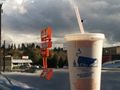
If I can't reach the hashpoint, at least I have milkshake. @47.8011,-122.3315
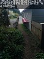
A close park exit... @47.8069,-122.3574
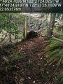
Another exit @47.8069,-122.3570


