Difference between revisions of "2015-04-04 37 -122"
imported>Codae (Created page with "{{subst:Expedition |lat = 37 |lon = -122 |date = 2015-04-04 }}") |
imported>Codae |
||
| Line 19: | Line 19: | ||
== Location == | == Location == | ||
<!-- where you've surveyed the hash to be --> | <!-- where you've surveyed the hash to be --> | ||
| + | On or by an expressway exit ramp in Oakland, California. | ||
== Participants == | == Participants == | ||
<!-- who attended: If you link to your wiki user name in this section, your expedition will be picked up by the various statistics generated for geohashing. You may use three tildes ~ as a shortcut to automatically insert the user signature of the account you are editing with. | <!-- who attended: If you link to your wiki user name in this section, your expedition will be picked up by the various statistics generated for geohashing. You may use three tildes ~ as a shortcut to automatically insert the user signature of the account you are editing with. | ||
--> | --> | ||
| + | [[User:Codae|Codae]] | ||
== Plans == | == Plans == | ||
<!-- what were the original plans --> | <!-- what were the original plans --> | ||
| + | Take the bus. The exit ramp in question is in fact part of a bus route, so this is an easy feat. I worked out that I could get going around 2:50 and make it to the geohash in time for the 4:00 meetup. I thought it necessary to attempt this geohash due to its accessibility and as an excuse not to try my hardest to acquire transport to the [[2015-04-04 Globalhash]] in Montana. | ||
== Expedition == | == Expedition == | ||
<!-- how it all turned out. your narrative goes here. --> | <!-- how it all turned out. your narrative goes here. --> | ||
| + | Riding the bus on the outbound leg, I got worried it had slipped far enough behind schedule that I wouldn't make it to the geohash on time. So I hopped over to the BART train system, which is generally faster. I exited at the Coliseum station, which put me virtually in sight of the hashpoint, and hurried over. I reached the exit ramp at 3:57. | ||
| + | |||
| + | A man driving a car down from the expressway asked me what I was doing. I said, "Taking pictures," which seemed to satisfy him. | ||
| + | |||
| + | A dirt footpath existed along the ramp, but it appeared obstructed by a large bush. Then I stepped out into the road and found that it continued afterward to the junction between the freeway bridge and the ground. I guess it is typical, when traveling between that sheltered location and the sidewalk, to take a few steps on the asphalt to get around the bush. | ||
| + | |||
| + | Despite Google Earth's suggestion, the geohash was not, by my GPS readings, on the ramp itself, which made my GPS dance a bit safer than I'd expected. I got good eyeball readings, but due to solar glare and a lack of convenient shade I couldn't tell whether I'd gotten any readable documentation until after the expedition. | ||
| + | |||
| + | I waited around for a few minutes. Not finding any geohashers, I left. My predominant thought on the way back was that I probably shouldn't walk three-quarters of a mile back to International Boulevard alone in one of the deadliest regions of Oakland, but when I did so I suffered nothing worse than being barked at by two out of four dogs. | ||
| + | |||
| + | Somewhere between there and home I lost my water bottle. One the one hand, this is an inconvenience because it leaves me without a water bottle. On the other hand, this water bottle was the one I bought on the [[2014-08-24 37 -122]] expedition, and it was looking pretty yellow and carcinogenic by this point. Maybe I should invest in a metal one. | ||
== Tracklog == | == Tracklog == | ||
| Line 38: | Line 52: | ||
--> | --> | ||
<gallery perrow="5"> | <gallery perrow="5"> | ||
| + | Image:2015-04-04 37 -122 Arrival.jpg | In time for the meetup, but not quite to the hashpoint. | ||
| + | Image:2015-04-04 37 -122 Bush.jpg | Is this the end of the road? | ||
| + | Image:2015-04-04 37 -122 Proof.jpg | Nope. And with impeccable timing, too. | ||
| + | Image:2015-04-04 37 -122 Hashpoint.jpg | Would you believe the [[Geotrash]] achievement never crossed my mind while I was here? | ||
</gallery> | </gallery> | ||
| Line 43: | Line 61: | ||
{{#vardefine:ribbonwidth|800px}} | {{#vardefine:ribbonwidth|800px}} | ||
<!-- Add any achievement ribbons you earned below, or remove this section --> | <!-- Add any achievement ribbons you earned below, or remove this section --> | ||
| − | + | {{Land geohash|latitude=37|longitude=-122|date=2015-04-04|name=Codae}} | |
| + | {{Public transport geohash|latitude=37|longitude=-122|date=2015-04-04|name=Codae}} | ||
| + | {{xkcd centurion|count=3|name=Codae}} | ||
<!-- =============== USEFUL CATEGORIES FOLLOW ================ | <!-- =============== USEFUL CATEGORIES FOLLOW ================ | ||
Delete the next line ONLY if you have chosen the appropriate categories below. If you are unsure, don't worry. People will read your report and help you with the classification.--> | Delete the next line ONLY if you have chosen the appropriate categories below. If you are unsure, don't worry. People will read your report and help you with the classification.--> | ||
| − | |||
<!-- ==REQUEST FOR TWITTER BOT== Please leave either the New report or the Expedition planning category in as long as you work on it. This helps the twitter bot a lot with announcing the right outcome at the right moment. --> | <!-- ==REQUEST FOR TWITTER BOT== Please leave either the New report or the Expedition planning category in as long as you work on it. This helps the twitter bot a lot with announcing the right outcome at the right moment. --> | ||
| − | |||
| − | |||
| − | |||
| − | |||
| − | + | ||
| + | |||
[[Category:Expeditions]] | [[Category:Expeditions]] | ||
| − | + | ||
[[Category:Expeditions with photos]] | [[Category:Expeditions with photos]] | ||
| − | |||
| − | |||
| − | |||
| − | + | ||
[[Category:Coordinates reached]] | [[Category:Coordinates reached]] | ||
| − | |||
| − | |||
| − | |||
| − | |||
| − | |||
| − | |||
| − | |||
| − | |||
| − | |||
| − | |||
| − | |||
| − | |||
| − | |||
| − | |||
| − | |||
| − | |||
| − | |||
| − | |||
Revision as of 02:08, 5 April 2015
| Sat 4 Apr 2015 in 37,-122: 37.7515844, -122.1959298 geohashing.info google osm bing/os kml crox |
Location
On or by an expressway exit ramp in Oakland, California.
Participants
Plans
Take the bus. The exit ramp in question is in fact part of a bus route, so this is an easy feat. I worked out that I could get going around 2:50 and make it to the geohash in time for the 4:00 meetup. I thought it necessary to attempt this geohash due to its accessibility and as an excuse not to try my hardest to acquire transport to the 2015-04-04 Globalhash in Montana.
Expedition
Riding the bus on the outbound leg, I got worried it had slipped far enough behind schedule that I wouldn't make it to the geohash on time. So I hopped over to the BART train system, which is generally faster. I exited at the Coliseum station, which put me virtually in sight of the hashpoint, and hurried over. I reached the exit ramp at 3:57.
A man driving a car down from the expressway asked me what I was doing. I said, "Taking pictures," which seemed to satisfy him.
A dirt footpath existed along the ramp, but it appeared obstructed by a large bush. Then I stepped out into the road and found that it continued afterward to the junction between the freeway bridge and the ground. I guess it is typical, when traveling between that sheltered location and the sidewalk, to take a few steps on the asphalt to get around the bush.
Despite Google Earth's suggestion, the geohash was not, by my GPS readings, on the ramp itself, which made my GPS dance a bit safer than I'd expected. I got good eyeball readings, but due to solar glare and a lack of convenient shade I couldn't tell whether I'd gotten any readable documentation until after the expedition.
I waited around for a few minutes. Not finding any geohashers, I left. My predominant thought on the way back was that I probably shouldn't walk three-quarters of a mile back to International Boulevard alone in one of the deadliest regions of Oakland, but when I did so I suffered nothing worse than being barked at by two out of four dogs.
Somewhere between there and home I lost my water bottle. One the one hand, this is an inconvenience because it leaves me without a water bottle. On the other hand, this water bottle was the one I bought on the 2014-08-24 37 -122 expedition, and it was looking pretty yellow and carcinogenic by this point. Maybe I should invest in a metal one.
Tracklog
Photos
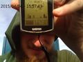
In time for the meetup, but not quite to the hashpoint.
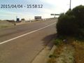
Is this the end of the road?
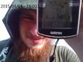
Nope. And with impeccable timing, too.
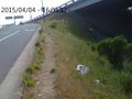
Would you believe the Geotrash achievement never crossed my mind while I was here?


Achievements
Codae earned the Land geohash achievement
|
Codae earned the Public transport geohash achievement
|
Codae earned the xkcd Nullaturion achievement
|