Difference between revisions of "2015-04-09 44 11"
imported>LucaPost m (LucaPost moved page 2015-04-08 44 11 to 2015-04-09 44 11 over redirect) |
m (Location correction) |
||
| (14 intermediate revisions by 4 users not shown) | |||
| Line 12: | Line 12: | ||
| lat=44 | | lat=44 | ||
| lon=11 | | lon=11 | ||
| − | | date= | + | | date=2015-04-09 |
}} | }} | ||
| Line 19: | Line 19: | ||
== Location == | == Location == | ||
<!-- where you've surveyed the hash to be --> | <!-- where you've surveyed the hash to be --> | ||
| + | Despite what the wiki is now displaying I went out chasing LatLong Coordinates 44.397599, 11.445883, as the Geohash+ app (and other geohash tools) was displaying for this date. | ||
| + | I don't know which one is wrong, but the experience in itself was quite challenging/rewarding, given the spot was lost in an hidden side valley of the 'Regional Park Dei Gessi' and after jumping 2 fences I had to walk through the thikkest 'jungle' the final 200 meters. | ||
== Participants == | == Participants == | ||
| − | <!-- who attended: If you link to your wiki user name in this section, your expedition will be picked up by the various statistics generated for geohashing. You may use three tildes ~ as a shortcut to automatically insert the user signature of the account you are editing with. | + | |
| + | -- just Me! [[User:LucaPost|LucaPost]] ([[User talk:LucaPost|talk]]) | ||
| + | <!-- who attended: If you link to | ||
| + | |||
| + | your wiki user name in this section, your expedition will be picked up by the various statistics generated for geohashing. You may use three tildes ~ as a shortcut to automatically insert the user signature of the account you are editing with. | ||
--> | --> | ||
== Plans == | == Plans == | ||
| + | |||
| + | |||
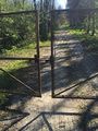
| + | Just like the other expedition in the same area the spot looked easy on the map, just on the side of a dirt road, but once there I discovered the dirt road was gated, and after 500 hundred meters I procedeed in the fields in the direction of the spot. | ||
<!-- what were the original plans --> | <!-- what were the original plans --> | ||
| Line 38: | Line 47: | ||
--> | --> | ||
<gallery perrow="5"> | <gallery perrow="5"> | ||
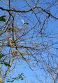
| + | moreJungle.jpg | Biodiversity thickness | ||
| + | gate1.jpg | | ||
| + | theProof2.jpg | | ||
| + | me&theFence.jpg | all that wild walking to end up on a fence ! | ||
| + | theLocals.jpg | nice family of these guys all around, too far for the iphone zoom | ||
</gallery> | </gallery> | ||
| Line 44: | Line 58: | ||
<!-- Add any achievement ribbons you earned below, or remove this section --> | <!-- Add any achievement ribbons you earned below, or remove this section --> | ||
| − | |||
| − | |||
| − | |||
| − | |||
| − | |||
| − | |||
| − | |||
| − | |||
| − | |||
| − | |||
| − | |||
| − | |||
| − | |||
[[Category:Expeditions]] | [[Category:Expeditions]] | ||
| − | |||
[[Category:Expeditions with photos]] | [[Category:Expeditions with photos]] | ||
| − | |||
| − | |||
| − | |||
| − | |||
| − | |||
[[Category:Coordinates reached]] | [[Category:Coordinates reached]] | ||
| − | + | {{location|IT|ER}} | |
| − | |||
| − | |||
| − | |||
| − | |||
| − | |||
| − | |||
| − | |||
| − | |||
| − | |||
| − | |||
| − | |||
| − | |||
| − | |||
| − | |||
| − | |||
| − | |||
| − | |||
Latest revision as of 15:13, 28 July 2021
| Thu 9 Apr 2015 in 44,11: 44.3975994, 11.4458827 geohashing.info google osm bing/os kml crox |
Location
Despite what the wiki is now displaying I went out chasing LatLong Coordinates 44.397599, 11.445883, as the Geohash+ app (and other geohash tools) was displaying for this date. I don't know which one is wrong, but the experience in itself was quite challenging/rewarding, given the spot was lost in an hidden side valley of the 'Regional Park Dei Gessi' and after jumping 2 fences I had to walk through the thikkest 'jungle' the final 200 meters.
Participants
Plans
Just like the other expedition in the same area the spot looked easy on the map, just on the side of a dirt road, but once there I discovered the dirt road was gated, and after 500 hundred meters I procedeed in the fields in the direction of the spot.
Expedition
Tracklog
Photos
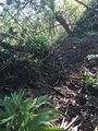
Biodiversity thickness
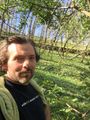
all that wild walking to end up on a fence !
nice family of these guys all around, too far for the iphone zoom


