Difference between revisions of "2015-04-09 52 1"
From Geohashing
imported>Sourcerer m ([live] Arrived.) |
imported>FippeBot m (Location) |
||
| (8 intermediate revisions by one other user not shown) | |||
| Line 1: | Line 1: | ||
| − | |||
| − | |||
| − | |||
| − | |||
| − | |||
| − | |||
| − | |||
| − | |||
| − | |||
| − | |||
{{meetup graticule | {{meetup graticule | ||
| lat=52 | | lat=52 | ||
| lon=1 | | lon=1 | ||
| date=2015-04-09 | | date=2015-04-09 | ||
| + | | graticule_name=Norwich, UK | ||
| + | | graticule_link=Norwich, United Kingdom | ||
}} | }} | ||
| − | |||
| − | |||
__NOTOC__ | __NOTOC__ | ||
== Location == | == Location == | ||
| − | + | ||
| + | Close to the road, in a field near Saint Michael, South Elmham, Suffolk, UK. | ||
== Participants == | == Participants == | ||
| − | |||
| − | |||
| − | + | [[User:Sourcerer|Sourcerer]] | |
| − | |||
== Expedition == | == Expedition == | ||
| − | |||
| + | Hash two of two spanning midnight. [[2015-04-08 52 1]] and [[2015-04-09 52 1]] | ||
*Arrived. -- [[User:Sourcerer|Sourcerer]] ([[User talk:Sourcerer|talk]]) [http://www.openstreetmap.org/?lat=52.39759147&lon=1.44586623&zoom=16&layers=B000FTF @52.3976,1.4459] 00:32, 9 April 2015 (GMT+01:00) | *Arrived. -- [[User:Sourcerer|Sourcerer]] ([[User talk:Sourcerer|talk]]) [http://www.openstreetmap.org/?lat=52.39759147&lon=1.44586623&zoom=16&layers=B000FTF @52.3976,1.4459] 00:32, 9 April 2015 (GMT+01:00) | ||
| − | + | ||
| − | + | In the car, I got to within 15 to 20 metres. To reach the point properly, the field entrance had to be located in the fog which was still thick. Then it was easy. Damp feet in wet grass was the only price to pay. | |
== Photos == | == Photos == | ||
| Line 40: | Line 28: | ||
--> | --> | ||
<gallery perrow="5"> | <gallery perrow="5"> | ||
| + | |||
| + | Image:2015-04-09_52_1_Sourcerer_1428535991652.jpg | Proof. [http://www.openstreetmap.org/?lat=52.39760756&lon=1.44590378&zoom=16&layers=B000FTF @52.3976,1.4459] | ||
| + | Image:2015-04-09_52_1_Sourcerer.jpg | Track in Google Earth | ||
</gallery> | </gallery> | ||
== Achievements == | == Achievements == | ||
{{#vardefine:ribbonwidth|800px}} | {{#vardefine:ribbonwidth|800px}} | ||
| − | |||
| + | {{Midnight geohash | ||
| + | | latitude = 52 | ||
| + | | longitude = 1 | ||
| + | | date = 2015-04-09 | ||
| + | | name = Sourcerer | ||
| + | }} | ||
| − | + | {{Sourcerer_links | |
| − | + | | prev = 2015-04-08 52 1 | |
| − | + | | curr = 2015-04-09 52 1 | |
| − | + | | next = 2015-04-10 52 1 | |
| − | + | | date = 2015-04-09 | |
| − | + | }} | |
| − | |||
| − | |||
| − | |||
| − | |||
| − | |||
[[Category:Expeditions]] | [[Category:Expeditions]] | ||
| − | |||
[[Category:Expeditions with photos]] | [[Category:Expeditions with photos]] | ||
| − | |||
| − | |||
| − | |||
| − | |||
| − | |||
[[Category:Coordinates reached]] | [[Category:Coordinates reached]] | ||
| − | + | {{location|GB|ENG|SFK}} | |
| − | |||
| − | |||
| − | |||
| − | |||
| − | |||
| − | |||
| − | |||
| − | |||
| − | |||
| − | |||
| − | |||
| − | |||
| − | |||
| − | |||
| − | |||
| − | |||
| − | |||
Latest revision as of 03:17, 15 August 2019
| Thu 9 Apr 2015 in Norwich, UK: 52.3975994, 1.4458827 geohashing.info google osm bing/os kml crox |
Location
Close to the road, in a field near Saint Michael, South Elmham, Suffolk, UK.
Participants
Expedition
Hash two of two spanning midnight. 2015-04-08 52 1 and 2015-04-09 52 1
- Arrived. -- Sourcerer (talk) @52.3976,1.4459 00:32, 9 April 2015 (GMT+01:00)
In the car, I got to within 15 to 20 metres. To reach the point properly, the field entrance had to be located in the fog which was still thick. Then it was easy. Damp feet in wet grass was the only price to pay.
Photos
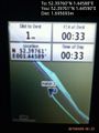
Proof. @52.3976,1.4459
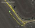
Track in Google Earth


Achievements
Sourcerer earned the Midnight Geohash achievement
|
Expeditions and Plans
| 2015-04-09 | ||
|---|---|---|
| Bologna, Italy | LucaPost | Despite what the wiki is now displaying I went out chasing LatLong Coordina... |
| Zürich, Switzerland | Calamus | On Badenerstrasse in Schlieren. |
| Kassel, Germany | GeorgDerReisende | The hash lay in a field near Espenau. |
| Norwich, United Kingdom | Sourcerer | Close to the road, in a field near Saint Michael, South Elmham, Suffolk, UK... |
Sourcerer's Expedition Links
2015-04-08 52 1 - 2015-04-09 52 1 - 2015-04-10 52 1 - KML file download of Sourcerer's expeditions for use with Google Earth.