Difference between revisions of "2015-05-01 51 10"
From Geohashing
imported>GeorgDerReisende (create page) |
imported>FippeBot m (Location) |
||
| (2 intermediate revisions by one other user not shown) | |||
| Line 1: | Line 1: | ||
| − | |||
| − | |||
| − | |||
| − | |||
| − | |||
| − | |||
| − | |||
| − | |||
| − | |||
| − | |||
{{meetup graticule | {{meetup graticule | ||
| lat=51 | | lat=51 | ||
| Line 18: | Line 8: | ||
__NOTOC__ | __NOTOC__ | ||
== Location == | == Location == | ||
| − | + | ||
| + | The hash lay on the cycleway along the former railway in Ferna. | ||
== Participants == | == Participants == | ||
| − | + | ||
| − | + | [[User:GeorgDerReisende|GeorgDerReisende]] | |
== Plans == | == Plans == | ||
| − | + | ||
| + | Hitchhiking and walking. | ||
== Expedition == | == Expedition == | ||
| − | |||
| − | + | I left home at 10, started to hitchhike at 11 and got the tenth car. With three cars I arrived at Gieboldehausen, there I had to wait one hour. I arrived at Ferna at 14:38. Walked to the hash. Found it. On the way home I made a two hours walk around the city of Duderstadt. Later, on the motorway, there were only a small number of cars. I have never seen that before at that time. | |
| − | |||
== Photos == | == Photos == | ||
| − | |||
| − | |||
| − | |||
<gallery perrow="5"> | <gallery perrow="5"> | ||
| + | Image:2015-05-01 51 10 GeorgDerReisende 5911.jpg | 0 meter | ||
| + | Image:2015-05-01 51 10 GeorgDerReisende 5913.jpg | nw | ||
| + | Image:2015-05-01 51 10 GeorgDerReisende 5914.jpg | ne | ||
| + | Image:2015-05-01 51 10 GeorgDerReisende 5915.jpg | se | ||
| + | Image:2015-05-01 51 10 GeorgDerReisende 5916.jpg | sw | ||
| + | Image:2015-05-01 51 10 GeorgDerReisende 5912.jpg | grin | ||
| + | Image:2015-05-01 51 10 GeorgDerReisende 5959.jpg | main street | ||
| + | Image:2015-05-01 51 10 GeorgDerReisende 6198.jpg | empty motorway | ||
</gallery> | </gallery> | ||
| Line 44: | Line 39: | ||
<!-- Add any achievement ribbons you earned below, or remove this section --> | <!-- Add any achievement ribbons you earned below, or remove this section --> | ||
| + | {{Thumbs Up | latitude = 51 | longitude = 10 | date = 2015-05-01 | name = GeorgDerReisende }} | ||
| − | + | {{Regional geohashing | name = GeorgDerReisende | region = county Eichsfeld | count = 2 }} | |
| − | |||
| − | |||
| − | + | [[Category:Expeditions]] | |
| − | + | [[Category:Expeditions with photos]] | |
| − | |||
| − | [[Category: | ||
| − | |||
| − | |||
| − | |||
| − | |||
| − | |||
| − | |||
| − | |||
| − | |||
| − | |||
| − | |||
[[Category:Coordinates reached]] | [[Category:Coordinates reached]] | ||
| − | + | {{location|DE|TH|EIC}} | |
| − | |||
| − | |||
| − | |||
| − | |||
| − | |||
| − | |||
| − | |||
| − | |||
| − | |||
| − | |||
| − | |||
| − | |||
| − | |||
| − | |||
| − | |||
| − | |||
| − | |||
Latest revision as of 03:30, 15 August 2019
| Fri 1 May 2015 in 51,10: 51.4536787, 10.3086616 geohashing.info google osm bing/os kml crox |
Location
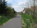
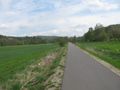
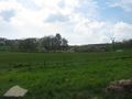
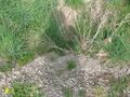
The hash lay on the cycleway along the former railway in Ferna.
Participants
Plans
Hitchhiking and walking.
Expedition
I left home at 10, started to hitchhike at 11 and got the tenth car. With three cars I arrived at Gieboldehausen, there I had to wait one hour. I arrived at Ferna at 14:38. Walked to the hash. Found it. On the way home I made a two hours walk around the city of Duderstadt. Later, on the motorway, there were only a small number of cars. I have never seen that before at that time.
Photos
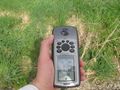
0 meter
nw
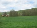
ne
se
sw
grin
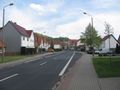
main street
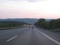
empty motorway


Achievements
GeorgDerReisende earned the Thumbs Up Geohash Achievement
|
GeorgDerReisende earned the Regional geohashing achievement
|