Difference between revisions of "2015-05-08 52 9"
imported>GeorgDerReisende (new expedition to Langenhagen-Kananohe) |
m (Adding hours) |
||
| (11 intermediate revisions by 3 users not shown) | |||
| Line 1: | Line 1: | ||
{{meetup graticule | {{meetup graticule | ||
| − | | lat=52 | + | |lat = 52 |
| − | | lon=9 | + | |lon = 9 |
| − | | date=2015-05-08 | + | |date = 2015-05-08 |
| + | |graticule_name = Hannover | ||
| + | |graticule_link = Hannover, Germany | ||
}} | }} | ||
| − | < | + | <p style="border:2px solid #884;background:#ff8;padding:20px;font-weight:bold;text-align:center;">Hallo, Herr Hölter!</p> |
| − | |||
| − | |||
| − | |||
| − | |||
| − | |||
| − | |||
| − | [[ | + | ==Location== |
| + | The Geohash lies in the forest of [[wikipedia:Kananohe|Kananohe]]. | ||
| − | == | + | ==Participants== |
| + | *[[User:GeorgDerReisende|GeorgDerReisende]] | ||
| + | *[[User:Fippe|Fippe]] | ||
| + | ==Plans== | ||
| + | ===GeorgDerReisende=== | ||
Hitchhiking, public transport and walking. I will leave home at 10:30, start to hitchhike at 11:30, try to arrive near Hannover at 13:30, one hour for the transfer by public transport to Langenhagen-Kaltenweide and one hour of walking. Calculated time of arrival 15:30. Depending of which way I get I am walking along Kananoher Straße, Heideschlösschen, Herrendamm, looking to the shelter in the forest, visiting the hash, looking to the viewing tower of the Bissendorfer Moor and walking to Kiebitzkrug. Or the same way, but left around. I will not wait at the hash more than some minutes. | Hitchhiking, public transport and walking. I will leave home at 10:30, start to hitchhike at 11:30, try to arrive near Hannover at 13:30, one hour for the transfer by public transport to Langenhagen-Kaltenweide and one hour of walking. Calculated time of arrival 15:30. Depending of which way I get I am walking along Kananoher Straße, Heideschlösschen, Herrendamm, looking to the shelter in the forest, visiting the hash, looking to the viewing tower of the Bissendorfer Moor and walking to Kiebitzkrug. Or the same way, but left around. I will not wait at the hash more than some minutes. | ||
| − | == | + | ===Fippe=== |
| − | + | I am planning to go as well, but probably much later than GeorgDerReisende, so we probably won't meet. | |
| − | == | + | ==Expeditions== |
| − | + | ===GeorgDerReisende=== | |
| + | My timetable of the journey was: leaving home at 10:30, starting hitchhiking at 11:00, a lift to Hedemünden at 12:19, arriving 12:34, leaving Hedemünden at 12:45, arriving at Göttingen service station at 12:53, leaving 13:00, arriving at junction Großburgwedel (IKEA) at 14:33, arriving at Isernhagen NB at 15:16, arriving at Langenhagen Reuterdamm at 15:37, took the bus to Kananoher Straße, arrived there 15:53, got a lift and arrived at the forest at 15:58. Visited the shelter at 16:18. Arrived at the hash at 16:50. | ||
| − | + | A first try to walk along a muddy (moory?) forest way failed, later I found out about fences around there. Then the first view to the hash. Walked along an alley and found a meadow. I thought about reaching the hash. All the ways there had ditches on both sides with moory water in them and I decided to walk across the meadow. And found a dry ditch and the hash was on the other side. With the help of a tree I crossed the ditch and found the hash. I saw for a moment the zero. But seeing the beehives, I didn't want to make a big dance, may be it would be a dance with the bees. | |
| − | |||
| − | |||
| − | |||
| − | |||
| − | |||
| − | + | After this adventure I wanted to have a look to the big moor. The direct way looked very muddy and I saw a young deer there. And again, I didn't want to disturb the deers' children and walked around the forest. I had views to some types of moor. There were some big raptors. My head feels now like two heads. | |
| − | |||
| − | |||
| + | For the way home I started to hitchhike at 18:30 and arrived at home at 23:30. On the motorway I got a truck, which drove all the way with 90 km/h, also up the steep mountains at the Werra bridge. | ||
| − | + | ===Fippe=== | |
| − | + | After taking the tram to ''Nordhafen'' and from there the bus to ''Rhodopark'', I was on the edge to the forest of Kananohe. I started walking into the forest and was quite surprised that this part of nature could exist so close to Hannover Airport. The forest wasn't only beutiful, but also large, and by that I mean I-grew-up-in-the-countryside-and-still-am-impressed large. After a while, I got attacked by [[wikipedia:Velociraptor|Mosquito]]es and had to put my jacket on. | |
| − | [[ | ||
| − | + | When I came closer to the hash, I noticed that Georg must have been here before. It seems to me that we both made the same wrong assumption that the hash was located on a meadow (inside the forest), because I went through the meadow and saw footsteps. The hash, however, was located on the edge to the forest again, so it would have been more clever of both of us just to have followed the track. | |
| − | + | Anyway, when I finally reached the hash, it was 17:30 and Georg of course was already gone. Instead, I saw that an apiary with several hives was very close to the hash. After watching the bees for a while, I wrote a short note to the apiarist, Mr. Hölter, told him that the internet had visited and included the URL to this page. | |
| − | |||
| − | |||
| − | |||
| − | + | On my way back, I saw a canola field in the middle of the forest. There was a ladder stand (for hunters, probably - I saw deers, too) next to it, so I could take nice pictures. | |
| − | |||
| − | |||
| − | |||
| − | |||
| − | |||
| − | |||
| − | |||
| − | |||
| − | |||
| + | ==Photos== | ||
| + | ===GeorgDerReisende=== | ||
| + | <gallery perrow="5"> | ||
| + | Image:2015-05-08 52 9 GeorgDerReisende 6612.jpg | the start of the walk | ||
| + | Image:2015-05-08 52 9 GeorgDerReisende 6619.jpg | the shelter | ||
| + | Image:2015-05-08 52 9 GeorgDerReisende 6635.jpg | first view to the hash | ||
| + | Image:2015-05-08 52 9 GeorgDerReisende 6637.jpg | the alley to the hash | ||
| + | Image:2015-05-08 52 9 GeorgDerReisende 6639.jpg | view to the hash | ||
| + | Image:2015-05-08 52 9 GeorgDerReisende 6642.jpg | dry ditch | ||
| + | Image:2015-05-08 52 9 GeorgDerReisende 6646.jpg | one meter | ||
| + | Image:2015-05-08 52 9 GeorgDerReisende 6644.jpg | to the north | ||
| + | Image:2015-05-08 52 9 GeorgDerReisende 6648.jpg | to the west | ||
| + | Image:2015-05-08 52 9 GeorgDerReisende 6649.jpg | to the south | ||
| + | Image:2015-05-08 52 9 GeorgDerReisende 6650.jpg | to the east | ||
| + | Image:2015-05-08 52 9 GeorgDerReisende 6651.jpg | GeorgDerReisende | ||
| + | Image:2015-05-08 52 9 GeorgDerReisende 6653.jpg | muddy forest way with young deers | ||
| + | Image:2015-05-08 52 9 GeorgDerReisende 6667.jpg | inhabitant of the forest | ||
| + | Image:2015-05-08 52 9 GeorgDerReisende 6691.jpg | another inhabitant of the forest | ||
| + | Image:2015-05-08 52 9 GeorgDerReisende 6699.jpg | Bissendorfer Moor | ||
| + | Image:2015-05-08 52 9 GeorgDerReisende 6680.jpg | moor | ||
| + | Image:2015-05-08 52 9 GeorgDerReisende 6707.jpg | moor | ||
| + | Image:2015-05-08 52 9 GeorgDerReisende 6729.jpg | moor | ||
| + | </gallery> | ||
| − | -- | + | ===Fippe=== |
| − | + | <gallery> | |
| − | -- | + | 2015-05-08 52 09 01 Proof.png | Proof |
| − | + | 2015-05-08 52 09 02 Forest.jpg | The forest | |
| − | + | 2015-05-08 52 09 03 Forest.jpg | More forest | |
| − | + | 2015-05-08 52 09 04 Cows.jpg | Hash Cows | |
| − | + | 2015-05-08 52 09 05 Forest.jpg | Even more forest | |
| − | + | 2015-05-08 52 09 06 Oak.jpg | An Oak | |
| + | 2015-05-08 52 09 07 Footprint.jpg | Georg was here | ||
| + | 2015-05-08 52 09 08 Geohash.jpg | The Geohash | ||
| + | 2015-05-08 52 09 09 Apiary.jpg | The Apiary | ||
| + | 2015-05-08 52 09 11 Hive.jpg | A hive | ||
| + | 2015-05-08 52 09 12 Bees.jpg | Some bees entering and exiting | ||
| + | 2015-05-08 52 09 13 Forest.jpg | The woods | ||
| + | 2015-05-08 52 09 14 Canola.jpg | The Canola field | ||
| + | </gallery> | ||
| − | + | ==Achievements== | |
| − | [[ | + | {{#vardefine:ribbonwidth|100%}} |
| − | + | {{consecutive geohash|count=3|latitude=51|longitude=9|date=2015-05-06|name=[[User:GeorgDerReisende|GeorgDerReisende]]}} | |
| − | + | {{consecutive geohash|count=2|latitude=52|longitude=9|date=2015-05-07|name=[[User:Fippe|Fippe]]}} | |
| − | [[ | + | {{land geohash|latitude=52|longitude=9|date=2015-05-08|name=[[User:GeorgDerReisende|GeorgDerReisende]] and [[User:Fippe|Fippe]]|image=2015-05-08 52 09 08 Geohash.jpg}} |
| − | + | __NOTOC__ | |
| + | [[Category:Expeditions]] | ||
| + | [[Category:Coordinates reached]] | ||
| + | [[Category:Expeditions with photos]] | ||
| + | {{location|DE|NI|H}} | ||
| + | {{user categories|user=Fippe|tram=15|bus=20|foot=8|hours=17}} | ||
Latest revision as of 19:01, 11 December 2022
| Fri 8 May 2015 in Hannover: 52.4928954, 9.6785815 geohashing.info google osm bing/os kml crox |
Hallo, Herr Hölter!
Location
The Geohash lies in the forest of Kananohe.
Participants
Plans
GeorgDerReisende
Hitchhiking, public transport and walking. I will leave home at 10:30, start to hitchhike at 11:30, try to arrive near Hannover at 13:30, one hour for the transfer by public transport to Langenhagen-Kaltenweide and one hour of walking. Calculated time of arrival 15:30. Depending of which way I get I am walking along Kananoher Straße, Heideschlösschen, Herrendamm, looking to the shelter in the forest, visiting the hash, looking to the viewing tower of the Bissendorfer Moor and walking to Kiebitzkrug. Or the same way, but left around. I will not wait at the hash more than some minutes.
Fippe
I am planning to go as well, but probably much later than GeorgDerReisende, so we probably won't meet.
Expeditions
GeorgDerReisende
My timetable of the journey was: leaving home at 10:30, starting hitchhiking at 11:00, a lift to Hedemünden at 12:19, arriving 12:34, leaving Hedemünden at 12:45, arriving at Göttingen service station at 12:53, leaving 13:00, arriving at junction Großburgwedel (IKEA) at 14:33, arriving at Isernhagen NB at 15:16, arriving at Langenhagen Reuterdamm at 15:37, took the bus to Kananoher Straße, arrived there 15:53, got a lift and arrived at the forest at 15:58. Visited the shelter at 16:18. Arrived at the hash at 16:50.
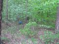
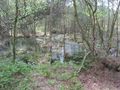
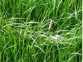
A first try to walk along a muddy (moory?) forest way failed, later I found out about fences around there. Then the first view to the hash. Walked along an alley and found a meadow. I thought about reaching the hash. All the ways there had ditches on both sides with moory water in them and I decided to walk across the meadow. And found a dry ditch and the hash was on the other side. With the help of a tree I crossed the ditch and found the hash. I saw for a moment the zero. But seeing the beehives, I didn't want to make a big dance, may be it would be a dance with the bees.
After this adventure I wanted to have a look to the big moor. The direct way looked very muddy and I saw a young deer there. And again, I didn't want to disturb the deers' children and walked around the forest. I had views to some types of moor. There were some big raptors. My head feels now like two heads.
For the way home I started to hitchhike at 18:30 and arrived at home at 23:30. On the motorway I got a truck, which drove all the way with 90 km/h, also up the steep mountains at the Werra bridge.
Fippe
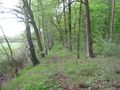
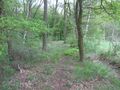
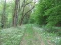
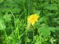
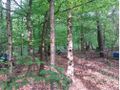
After taking the tram to Nordhafen and from there the bus to Rhodopark, I was on the edge to the forest of Kananohe. I started walking into the forest and was quite surprised that this part of nature could exist so close to Hannover Airport. The forest wasn't only beutiful, but also large, and by that I mean I-grew-up-in-the-countryside-and-still-am-impressed large. After a while, I got attacked by Mosquitoes and had to put my jacket on.
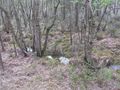
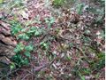
When I came closer to the hash, I noticed that Georg must have been here before. It seems to me that we both made the same wrong assumption that the hash was located on a meadow (inside the forest), because I went through the meadow and saw footsteps. The hash, however, was located on the edge to the forest again, so it would have been more clever of both of us just to have followed the track.
Anyway, when I finally reached the hash, it was 17:30 and Georg of course was already gone. Instead, I saw that an apiary with several hives was very close to the hash. After watching the bees for a while, I wrote a short note to the apiarist, Mr. Hölter, told him that the internet had visited and included the URL to this page.
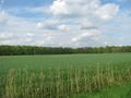
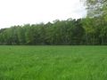
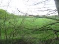
On my way back, I saw a canola field in the middle of the forest. There was a ladder stand (for hunters, probably - I saw deers, too) next to it, so I could take nice pictures.
Photos
GeorgDerReisende
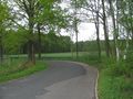
the start of the walk
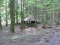
the shelter
first view to the hash
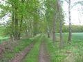
the alley to the hash
view to the hash
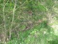
dry ditch
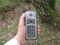
one meter
to the north
to the west
to the south
to the east
GeorgDerReisende
muddy forest way with young deers
inhabitant of the forest
another inhabitant of the forest
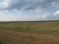
Bissendorfer Moor
moor
moor
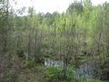
moor


Fippe

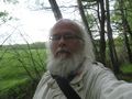
Proof
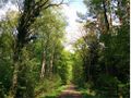
The forest
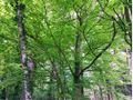
More forest
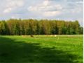
Hash Cows
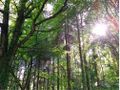
Even more forest
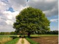
An Oak
Georg was here
The Geohash
The Apiary
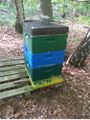
A hive
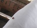
Some bees entering and exiting

The woods
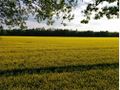
The Canola field


Achievements
GeorgDerReisende earned the Consecutive geohash achievement
|
Fippe earned the Consecutive geohash achievement
|
GeorgDerReisende and Fippe earned the Land geohash achievement
|