Difference between revisions of "2015-05-08 53 -2"
imported>Marsh (→Participants) |
imported>FippeBot m (Location) |
||
| (32 intermediate revisions by 2 users not shown) | |||
| Line 15: | Line 15: | ||
}} | }} | ||
| − | + | ||
__NOTOC__ | __NOTOC__ | ||
== Location == | == Location == | ||
| − | The geohash is located on Garswood Road within the village of Garswood, St. Helens. The surrounding area contains fields, residential houses, and commercial properties. | + | |
| + | The geohash is located on Garswood Road, one of the more major roads within the village of Garswood, St. Helens. The surrounding area contains fields, residential houses, and commercial properties. | ||
== Participants == | == Participants == | ||
| − | |||
| − | |||
| − | [[User:Marsh|Marsh]] | + | * [[User:Marsh|Marsh]] |
| + | * Marsh's fiancee | ||
== Plans == | == Plans == | ||
| − | + | ||
| + | At around 15:00 I looked at the peeron map and saw how close and accessible this geohash was. It was located just a few streets away from Garswood train station which I pass by quite often. | ||
| + | |||
| + | Unfortunately I had work at 19:00 and could not guarantee that I would make it there on time. Just before leaving for work I realised that my fiancee (provided she had finished her own shift) would be picking me up afterwards, and that if I could finish on time for 23:00 it would be possible to drive there immediately. | ||
| + | |||
| + | I sent her a message to confirm the plan but had to turn my phone off. I wouldn't come to know she had agreed to the plan until after my shift ended. | ||
== Expedition == | == Expedition == | ||
| − | |||
| − | + | ||
| − | + | There were issues at work that prevented me from leaving on time and despite extreme efforts I could only escape at 23:35. I was still determined to reach the geohash though, and understood that even if I didn't make it before midnight I was still having an adventure. I called my fiancee to drive down and, in my work clothes, sprinted towards the pickup point. I already had the coordinates entered into my phone's GPS so all we had to do was make it to Garswood station upon which I would direct her to the correct street. We raced down the roads as fast as we could (safely and legally.) The entire twenty minute journey encompassed me counting down time. | |
| + | |||
| + | "20 minutes. I don't think it'll happen!" | ||
| + | "5 minutes left, it's possible!" | ||
| + | "3 minutes, keep going!" | ||
| + | "2 minutes, I think we'll just miss this one!" | ||
| + | |||
| + | Incredibly we didn't have to drive to Garswood station. The route we took led us directly to the geohash. With less than one minute to spare we parked a few meters away and sprinted to the location. At this point my phone's GPS played up for a few seconds and I was seriously concerned. With just mere seconds till midnight it corrected itself and I found the hashpoint. It was literally two steps away from a bus stop in the middle of the thankfully empty road. I then watched the time on my phone jump to 00:00. I left satisfied and happy to have made my first midnight geohash! Bonus speed racer achievement as well. | ||
== Photos == | == Photos == | ||
| Line 40: | Line 51: | ||
--> | --> | ||
<gallery perrow="5"> | <gallery perrow="5"> | ||
| + | 2015-05-08 InsideCar.jpg | A view from inside the car as we raced to the geohash. The car's clock is a few minutes quick. | ||
| + | 2015-05-08 At Geohash.jpg | Stood directly at the hashpoint, two steps away from a Garswood bus stop. | ||
| + | 2015-05-08 GPS1a.png | This was our location at 23:47. We felt that the geohash was just too far away to reach on time. | ||
| + | 2015-05-08 GPS2a.png | At this point I was in shock at how close we were going to cut it. | ||
| + | 2015-05-08 GPS3a.png | It was 23:59 and we had made it. | ||
</gallery> | </gallery> | ||
| Line 46: | Line 62: | ||
<!-- Add any achievement ribbons you earned below, or remove this section --> | <!-- Add any achievement ribbons you earned below, or remove this section --> | ||
| + | {{land geohash | latitude = 53 | longitude = -2 | date = 2015-05-08 | name = Marsh| }} | ||
| − | + | {{Speed racer | latitude = 53 | longitude = -2 | date = 2015-05-08 | name = Marsh| }} | |
| − | |||
| − | |||
| − | |||
| − | |||
| − | + | {{Midnight geohash | latitude = 53 | longitude = -2 | date = 2015-05-08 | name = Marsh| }} | |
| − | |||
| − | |||
| − | |||
| − | |||
[[Category:Expeditions]] | [[Category:Expeditions]] | ||
| − | |||
| − | |||
| − | |||
| − | |||
| − | |||
| − | |||
| − | |||
[[Category:Coordinates reached]] | [[Category:Coordinates reached]] | ||
| − | + | {{location|GB|ENG|SHN}} | |
| − | |||
| − | |||
| − | |||
| − | |||
| − | |||
| − | |||
| − | |||
| − | |||
| − | |||
| − | |||
| − | |||
| − | |||
| − | |||
| − | |||
| − | |||
| − | |||
| − | |||
Latest revision as of 03:34, 15 August 2019
| Fri 8 May 2015 in 53,-2: 53.4928954, -2.6785815 geohashing.info google osm bing/os kml crox |
Location
The geohash is located on Garswood Road, one of the more major roads within the village of Garswood, St. Helens. The surrounding area contains fields, residential houses, and commercial properties.
Participants
- Marsh
- Marsh's fiancee
Plans
At around 15:00 I looked at the peeron map and saw how close and accessible this geohash was. It was located just a few streets away from Garswood train station which I pass by quite often.
Unfortunately I had work at 19:00 and could not guarantee that I would make it there on time. Just before leaving for work I realised that my fiancee (provided she had finished her own shift) would be picking me up afterwards, and that if I could finish on time for 23:00 it would be possible to drive there immediately.
I sent her a message to confirm the plan but had to turn my phone off. I wouldn't come to know she had agreed to the plan until after my shift ended.
Expedition
There were issues at work that prevented me from leaving on time and despite extreme efforts I could only escape at 23:35. I was still determined to reach the geohash though, and understood that even if I didn't make it before midnight I was still having an adventure. I called my fiancee to drive down and, in my work clothes, sprinted towards the pickup point. I already had the coordinates entered into my phone's GPS so all we had to do was make it to Garswood station upon which I would direct her to the correct street. We raced down the roads as fast as we could (safely and legally.) The entire twenty minute journey encompassed me counting down time.
"20 minutes. I don't think it'll happen!" "5 minutes left, it's possible!" "3 minutes, keep going!" "2 minutes, I think we'll just miss this one!"
Incredibly we didn't have to drive to Garswood station. The route we took led us directly to the geohash. With less than one minute to spare we parked a few meters away and sprinted to the location. At this point my phone's GPS played up for a few seconds and I was seriously concerned. With just mere seconds till midnight it corrected itself and I found the hashpoint. It was literally two steps away from a bus stop in the middle of the thankfully empty road. I then watched the time on my phone jump to 00:00. I left satisfied and happy to have made my first midnight geohash! Bonus speed racer achievement as well.
Photos

A view from inside the car as we raced to the geohash. The car's clock is a few minutes quick.
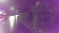
Stood directly at the hashpoint, two steps away from a Garswood bus stop.
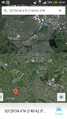
This was our location at 23:47. We felt that the geohash was just too far away to reach on time.
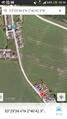
At this point I was in shock at how close we were going to cut it.
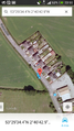
It was 23:59 and we had made it.


Achievements
Marsh earned the Land geohash achievement
|

Marsh earned the Midnight Geohash achievement
|