Difference between revisions of "2015-05-13 47 -122"
imported>Thomcat ([live picture] Poster [http://www.openstreetmap.org/?lat=47.79399722&lon=-122.18131793&zoom=16&layers=B000FTF @47.7940,-122.1813]) |
imported>FippeBot m (Location) |
||
| (One intermediate revision by one other user not shown) | |||
| Line 18: | Line 18: | ||
== Expedition == | == Expedition == | ||
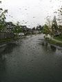
| − | + | As the first picture from my office parking lot indicates, it was definitely damp. Some would say actively raining. Also while driving out of the complex I spotted a bird in the local creek. Egret? See closeup below. | |
| − | + | Reached the street of the hashpoint easily, no chalk on this wet rainy day. I might have even driven through the point, but a lot of people milling about meant more eyes on the road than on the geohashdroid. I took the first left past to examine 38th Ave SE, which on the google satellite view looks like just trees. Indeed it is no longer trees but a street lined with houses. Ah, development. | |
| − | + | ||
| + | Coming back to where the people milled, I parked and milled with them. Waiting for other geohashers? I suspected not. Instead I worked my way to the hash point, snapping a photo and handling uploads. | ||
| + | |||
| + | Next the thing they were all waiting for roared north. Many parents moved over to collect their little ones, fresh from a pre school or kindergarten. Families now complete, they took to their individual vehicles and left me to my geohash. | ||
| + | |||
| + | I then put up a few posters for the neighbors or anyone else who arrives, then headed home. The dampness continued into the evening, with a light rain falling all through the baseball game I officiated. | ||
| + | |||
| + | Here's hoping we have a drier weekend! | ||
== Photos == | == Photos == | ||
| Line 32: | Line 39: | ||
Image:2015-05-13_47_-122_thomcat_1431549880215.jpg | [http://www.openstreetmap.org/?lat=47.79588062&lon=-122.19748613&zoom=16&layers=B000FTF @47.7959,-122.1975] | Image:2015-05-13_47_-122_thomcat_1431549880215.jpg | [http://www.openstreetmap.org/?lat=47.79588062&lon=-122.19748613&zoom=16&layers=B000FTF @47.7959,-122.1975] | ||
| + | |||
| + | Image:2015-05-13 47 -122 closeup.jpg | Closeup of previous image | ||
Image:2015-05-13_47_-122_thomcat_1431550248233.jpg | 38th now a through street [http://www.openstreetmap.org/?lat=47.79437256&lon=-122.18252945&zoom=16&layers=B000FTF @47.7944,-122.1825] | Image:2015-05-13_47_-122_thomcat_1431550248233.jpg | 38th now a through street [http://www.openstreetmap.org/?lat=47.79437256&lon=-122.18252945&zoom=16&layers=B000FTF @47.7944,-122.1825] | ||
| Line 49: | Line 58: | ||
| − | |||
| − | |||
| − | |||
[[Category:Expeditions]] | [[Category:Expeditions]] | ||
[[Category:Expeditions with photos]] | [[Category:Expeditions with photos]] | ||
[[Category:Coordinates reached]] | [[Category:Coordinates reached]] | ||
| − | + | {{location|US|WA|SN}} | |
| − | |||
| − | |||
| − | |||
| − | |||
| − | |||
| − | |||
| − | |||
| − | |||
| − | |||
| − | |||
Latest revision as of 03:36, 15 August 2019
| Wed 13 May 2015 in Seattle: 47.7941752, -122.1811098 geohashing.info google osm bing/os kml crox |
Location
On 39th Ave SE near 224th St SE in Canyon Park.
Participants
Plans
Stop by mid-day and leave a poster or two nearby. If dry enough, chalk the street also.
Expedition
As the first picture from my office parking lot indicates, it was definitely damp. Some would say actively raining. Also while driving out of the complex I spotted a bird in the local creek. Egret? See closeup below.
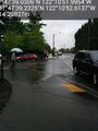
Reached the street of the hashpoint easily, no chalk on this wet rainy day. I might have even driven through the point, but a lot of people milling about meant more eyes on the road than on the geohashdroid. I took the first left past to examine 38th Ave SE, which on the google satellite view looks like just trees. Indeed it is no longer trees but a street lined with houses. Ah, development.
Coming back to where the people milled, I parked and milled with them. Waiting for other geohashers? I suspected not. Instead I worked my way to the hash point, snapping a photo and handling uploads.
Next the thing they were all waiting for roared north. Many parents moved over to collect their little ones, fresh from a pre school or kindergarten. Families now complete, they took to their individual vehicles and left me to my geohash.
I then put up a few posters for the neighbors or anyone else who arrives, then headed home. The dampness continued into the evening, with a light rain falling all through the baseball game I officiated.
Here's hoping we have a drier weekend!
Photos

Yep, it's damp. @47.7966,-122.2024
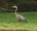
Closeup of previous image
38th now a through street @47.7944,-122.1825
Waiting for... @47.7942,-122.1813
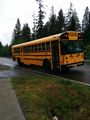
What they're really waiting for. @47.7942,-122.1811
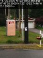
Poster @47.7940,-122.1813


