Difference between revisions of "2015-05-15 52 1"
From Geohashing
imported>Sourcerer m (→Links) |
imported>Sourcerer m (→Photo) |
||
| Line 26: | Line 26: | ||
<gallery perrow="5"> | <gallery perrow="5"> | ||
Image:2015-05-15_52_1_Sourcerer_1431726868085.jpg | Proof [http://www.openstreetmap.org/?lat=52.52035081&lon=1.12997711&zoom=16&layers=B000FTF @52.5204,1.1300] | Image:2015-05-15_52_1_Sourcerer_1431726868085.jpg | Proof [http://www.openstreetmap.org/?lat=52.52035081&lon=1.12997711&zoom=16&layers=B000FTF @52.5204,1.1300] | ||
| + | Image:2015-05-15_52_1_Sourcerer.jpg | Track in Google Earth | ||
</gallery> | </gallery> | ||
Revision as of 12:33, 18 July 2015
| Fri 15 May 2015 in 52,1: 52.5203570, 1.1299525 geohashing.info google osm bing/os kml crox |
Location
In a field near the Tacolneston TV and radio transmitter mast, Norfolk, UK.
Participants
Expedition
Expedition one of two spanning midnight. 2015-05-15 52 1 2015-05-16 52 1
- Arrived. -- Sourcerer (talk) @52.5204,1.1300 22:56, 15 May 2015 (GMT+01:00)
There was concrete hard standing at the field entrance and the hashpoint was a few paces into the wheat field. Very easy. There was intermittent light rain.
Photos
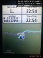
Proof @52.5204,1.1300
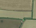
Track in Google Earth


Achievements
Sourcerer earned the Consecutive geohash achievement
|
Sourcerer earned the Double Century Coordinates Reached
|
Expeditions and Plans
| 2015-05-15 | ||
|---|---|---|
| Canberra, Australia | Someone went | Western shore of Springbank Island, Lake Burley Griffin, Canberra. (In Apri... |
| Stuttgart, Germany | Ekorren | located in Kusterdingen on a field. |
| Norwich, United Kingdom | Sourcerer | In a field near the Tacolneston TV and radio transmitter mast, Norfolk, UK.... |
Sourcerer's Expedition Links
2015-05-14 52 1 - 2015-05-15 52 1 - 2015-05-16 52 1 - KML file download of Sourcerer's expeditions for use with Google Earth.