Difference between revisions of "2015-05-18 52 1"
From Geohashing
imported>Sourcerer m ([live picture] Proof. [http://www.openstreetmap.org/?lat=52.82062411&lon=1.00559235&zoom=16&layers=B000FTF @52.8206,1.0056]) |
imported>Sourcerer m (→New Expedition) |
||
| Line 16: | Line 16: | ||
== Expedition == | == Expedition == | ||
| − | Expedition one of two spanning midnight | + | Expedition one of two spanning midnight. [[2015-05-18 52 1]] [[2015-05-19 52 1]] |
| + | *Arrived. -- [[User:Sourcerer|Sourcerer]] ([[User talk:Sourcerer|talk]]) [http://www.openstreetmap.org/?lat=52.82064021&lon=1.00559771&zoom=16&layers=B000FTF @52.8206,1.0056] 22:25, 18 May 2015 (GMT+01:00) | ||
| + | |||
| + | This was straightforward but spooky. The public footpath went through the graveyard of a ruined church with only the spire still standing. In the deepening dusk it was not too easy to find the way out. The path was a little overgrown in a very dark wood. Beyond the wood, the path cut across a field. There was a bridge over a deep drainage ditch and the hashpoint was about 40 metres from the bridge. I arrived a few minutes ahead of my planned schedule. | ||
| − | |||
== Photos == | == Photos == | ||
<gallery perrow="5"> | <gallery perrow="5"> | ||
| − | |||
Image:2015-05-18_52_1_Sourcerer_1431984228184.jpg | Proof. [http://www.openstreetmap.org/?lat=52.82062411&lon=1.00559235&zoom=16&layers=B000FTF @52.8206,1.0056] | Image:2015-05-18_52_1_Sourcerer_1431984228184.jpg | Proof. [http://www.openstreetmap.org/?lat=52.82062411&lon=1.00559235&zoom=16&layers=B000FTF @52.8206,1.0056] | ||
</gallery> | </gallery> | ||
| − | |||
| − | |||
| − | |||
== Other geohashing expeditions on the same day == | == Other geohashing expeditions on the same day == | ||
| Line 34: | Line 32: | ||
{{expedition summaries|2015-05-18}} | {{expedition summaries|2015-05-18}} | ||
| − | |||
| − | |||
| − | |||
| − | |||
[[Category:Expeditions]] | [[Category:Expeditions]] | ||
[[Category:Expeditions with photos]] | [[Category:Expeditions with photos]] | ||
[[Category:Coordinates reached]] | [[Category:Coordinates reached]] | ||
| − | |||
Revision as of 00:51, 19 May 2015
| Mon 18 May 2015 in 52,1: 52.8206488, 1.0056018 geohashing.info google osm bing/os kml crox |
Location
Close to a public footpath at Hindolveston, Norfolk, UK.
Participants
Expedition
Expedition one of two spanning midnight. 2015-05-18 52 1 2015-05-19 52 1
- Arrived. -- Sourcerer (talk) @52.8206,1.0056 22:25, 18 May 2015 (GMT+01:00)
This was straightforward but spooky. The public footpath went through the graveyard of a ruined church with only the spire still standing. In the deepening dusk it was not too easy to find the way out. The path was a little overgrown in a very dark wood. Beyond the wood, the path cut across a field. There was a bridge over a deep drainage ditch and the hashpoint was about 40 metres from the bridge. I arrived a few minutes ahead of my planned schedule.
Photos
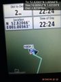
Proof. @52.8206,1.0056

Other geohashing expeditions on the same day
Expeditions and Plans
| 2015-05-18 | ||
|---|---|---|
| Sacramento, California | User:mlabelle | Someplace near Folsom |
| Norwich, United Kingdom | Sourcerer | Close to a public footpath at Hindolveston, Norfolk, UK. |