Difference between revisions of "2015-05-29 47 -122"
imported>Thomcat ([live picture] [http://www.openstreetmap.org/?lat=47.80765844&lon=-122.25234853&zoom=16&layers=B000FTF @47.8077,-122.2523]) |
imported>FippeBot m (Location) |
||
| (7 intermediate revisions by one other user not shown) | |||
| Line 18: | Line 18: | ||
== Expedition == | == Expedition == | ||
| − | + | Loaded up the dog and punched in the GPS, which chose a bit of an unusual route. Still, I enjoyed driving down a road I've never been on before. | |
| + | |||
| + | We parked north northwest of the hashpoint, investigating the park area first. Alas, dogs were not allowed on the playfield, but we will had a bit of fun wandering about. Then we headed east, towards some steps which lead... to the hashpoint? | ||
| + | |||
| + | Turns out no, the steps lead up to the tennis court. There was a path leading close to the retaining wall separating the park (and the hashpoint) from someone's house. I boosted Lucy up onto the wall and she was the first to reach the hashpoint. | ||
| + | |||
| + | *On the spot -- [[User:Thomcat|Thomcat]] ([[User talk:Thomcat|talk]]) [http://www.openstreetmap.org/?lat=47.80781280&lon=-122.25190134&zoom=16&layers=B000FTF @47.8078,-122.2519] 12:45, 29 May 2015 (PDT) | ||
| + | |||
| + | Alas I did not bring chalk, which would have lasted awhile on the wooden wall. | ||
| + | |||
| + | We then returned towards the car, where I discovered Lucy had picked up a tennis ball - perhaps near the court? Another man's trash is another dog's treasure! | ||
| + | |||
| + | Finally, we finished lunch off with a visit to Spud, a Friday favorite. | ||
== Tracklog == | == Tracklog == | ||
| Line 34: | Line 46: | ||
Image:2015-05-29_47_-122_thomcat_1432928158560.jpg | [http://www.openstreetmap.org/?lat=47.80765844&lon=-122.25234853&zoom=16&layers=B000FTF @47.8077,-122.2523] | Image:2015-05-29_47_-122_thomcat_1432928158560.jpg | [http://www.openstreetmap.org/?lat=47.80765844&lon=-122.25234853&zoom=16&layers=B000FTF @47.8077,-122.2523] | ||
| + | |||
| + | Image:2015-05-29_47_-122_thomcat_1432928307082.jpg | [http://www.openstreetmap.org/?lat=47.80789759&lon=-122.25195672&zoom=16&layers=B000FTF @47.8079,-122.2520] | ||
| + | |||
| + | Image:2015-05-29_47_-122_thomcat_1432928417000.jpg | [http://www.openstreetmap.org/?lat=47.80787427&lon=-122.25191368&zoom=16&layers=B000FTF @47.8079,-122.2519] | ||
| + | |||
| + | Image:2015-05-29_47_-122_thomcat_1432928569207.jpg | [http://www.openstreetmap.org/?lat=47.80776316&lon=-122.25178253&zoom=16&layers=B000FTF @47.8078,-122.2518] | ||
| + | |||
| + | Image:2015-05-29_47_-122_thomcat_1432928858641.jpg | Tennis ball geohash trash? [http://www.openstreetmap.org/?lat=47.80814332&lon=-122.25211559&zoom=16&layers=B000FTF @47.8081,-122.2521] | ||
| + | |||
| + | Image:2015-05-29_47_-122_thomcat_1432930744012.jpg | Post-geohash [http://www.openstreetmap.org/?lat=47.67834863&lon=-122.32698984&zoom=16&layers=B000FTF @47.6783,-122.3270] | ||
</gallery> | </gallery> | ||
| Line 40: | Line 62: | ||
<!-- Add any achievement ribbons you earned below, or remove this section --> | <!-- Add any achievement ribbons you earned below, or remove this section --> | ||
| − | |||
| − | |||
| − | |||
| − | |||
[[Category:Expeditions]] | [[Category:Expeditions]] | ||
[[Category:Expeditions with photos]] | [[Category:Expeditions with photos]] | ||
[[Category:Coordinates reached]] | [[Category:Coordinates reached]] | ||
| − | + | {{location|US|WA|SN}} | |
| − | |||
| − | |||
| − | |||
| − | |||
| − | |||
| − | |||
| − | |||
| − | |||
| − | |||
| − | |||
Latest revision as of 03:50, 15 August 2019
| Fri 29 May 2015 in Seattle: 47.8078270, -122.2518924 geohashing.info google osm bing/os kml crox |
Location
The corner of Logan Park, in the Alderwood Manor neighborhood.
Participants
Plans
Visit at lunchtime if I haven't heard from anyone else.
Expedition
Loaded up the dog and punched in the GPS, which chose a bit of an unusual route. Still, I enjoyed driving down a road I've never been on before.
We parked north northwest of the hashpoint, investigating the park area first. Alas, dogs were not allowed on the playfield, but we will had a bit of fun wandering about. Then we headed east, towards some steps which lead... to the hashpoint?
Turns out no, the steps lead up to the tennis court. There was a path leading close to the retaining wall separating the park (and the hashpoint) from someone's house. I boosted Lucy up onto the wall and she was the first to reach the hashpoint.
- On the spot -- Thomcat (talk) @47.8078,-122.2519 12:45, 29 May 2015 (PDT)
Alas I did not bring chalk, which would have lasted awhile on the wooden wall.
We then returned towards the car, where I discovered Lucy had picked up a tennis ball - perhaps near the court? Another man's trash is another dog's treasure!
Finally, we finished lunch off with a visit to Spud, a Friday favorite.
Tracklog
Photos
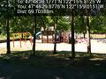
Playground @47.8083,-122.2525
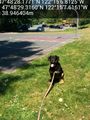
Tennis ball geohash trash? @47.8081,-122.2521

Post-geohash @47.6783,-122.3270


