Difference between revisions of "2015-06-02 47 -122"
imported>Thomcat ([live picture] [http://www.openstreetmap.org/?lat=47.21808170&lon=-122.37253146&zoom=16&layers=B000FTF @47.2181,-122.3725]) |
imported>FippeBot m (Location) |
||
| (One intermediate revision by one other user not shown) | |||
| Line 1: | Line 1: | ||
| − | |||
| − | |||
| − | |||
| − | |||
| − | |||
| − | |||
| − | |||
| − | |||
| − | |||
| − | |||
{{meetup graticule | {{meetup graticule | ||
| lat=47 | | lat=47 | ||
| lon=-122 | | lon=-122 | ||
| date=2015-06-02 | | date=2015-06-02 | ||
| + | | graticule_name=Seattle | ||
| + | | graticule_link=Seattle, Washington | ||
}} | }} | ||
| − | |||
__NOTOC__ | __NOTOC__ | ||
== Location == | == Location == | ||
| − | + | On a driveway in the town of Summit-Waller, just south of Tacoma. | |
== Participants == | == Participants == | ||
| − | + | * [[User:Thomcat|Thomcat]] | |
| − | + | ||
| + | == Expedition == | ||
| + | Tuesday was going to be a wasted day. I took the day off from work to take a load of rubbish to the dump, one of my school kids had late arrival, and a lot of ferrying people around was in order. The day also started poorly, "wrong side of the bed" and all that. What better way to lift my spirits than a geohash? | ||
| + | |||
| + | So, one kid delivered and one car empty (except for lingering fumes of some discarded chemical), I headed south. Rain threatened, which was worrying for the day's later activity, a Connie Mack baseball game. Nothing a geohasher couldn't handle, however. | ||
| + | |||
| + | GPS guidance system took me off the freeway and up a hill, past a sign for "Summit-Waller". Reading about it afterwards, I found it was originally part of the Puyallup reservation (which explains the Native American cemetery I drove past) and later parceled off into the town of Waller Road (not to be confused with Waller-Waller Warshington). I am unable to find more information on Summit, WA, but apparently the two townships merged into a joint tax base. | ||
| − | + | One main road leads up the hill and to the geohash, which I spotted easily. After I took a wrong turn, that is - car map and geohashdroid in rare disagreement. This first turn did lead me to a huge old tree. | |
| − | |||
| − | + | Returning to the road, I went half a block up to the driveway in question, heavily occupied by other vehicles. The actual hashpoint was located between that driveway and a longer drive to a property behind, and the border was marked with a nice prickly bush. It was also now raining lightly. I parked on the street and found the hashpoint to be close enough to the bush, and I didn't have to wander amongst the many cars (a suspicious activity in the best of times). | |
| − | |||
| − | + | Heading north again, I returned to my errands amidst heavy rain (at least in Tacoma). Fortunately this resulted in only light rain for the evening activities. | |
| − | |||
== Photos == | == Photos == | ||
| Line 38: | Line 32: | ||
--> | --> | ||
<gallery perrow="5"> | <gallery perrow="5"> | ||
| + | Image:2015-06-02_47_-122_thomcat_1433274086981.jpg | Summit-Waller [http://www.openstreetmap.org/?lat=47.21808170&lon=-122.37253146&zoom=16&layers=B000FTF @47.2181,-122.3725] | ||
Image:2015-06-02_47_-122_thomcat_1433273399761.jpg | Wrong turn, cool tree [http://www.openstreetmap.org/?lat=47.20272033&lon=-122.36372546&zoom=16&layers=B000FTF @47.2027,-122.3637] | Image:2015-06-02_47_-122_thomcat_1433273399761.jpg | Wrong turn, cool tree [http://www.openstreetmap.org/?lat=47.20272033&lon=-122.36372546&zoom=16&layers=B000FTF @47.2027,-122.3637] | ||
| Line 45: | Line 40: | ||
Image:2015-06-02_47_-122_thomcat_1433273631179.jpg | [http://www.openstreetmap.org/?lat=47.20183159&lon=-122.36493744&zoom=16&layers=B000FTF @47.2018,-122.3649] | Image:2015-06-02_47_-122_thomcat_1433273631179.jpg | [http://www.openstreetmap.org/?lat=47.20183159&lon=-122.36493744&zoom=16&layers=B000FTF @47.2018,-122.3649] | ||
| − | |||
</gallery> | </gallery> | ||
| Line 52: | Line 46: | ||
<!-- Add any achievement ribbons you earned below, or remove this section --> | <!-- Add any achievement ribbons you earned below, or remove this section --> | ||
| − | |||
| − | |||
| − | |||
| − | |||
| − | |||
| − | |||
| − | |||
| − | |||
| − | |||
| − | |||
| − | |||
| − | |||
| − | |||
[[Category:Expeditions]] | [[Category:Expeditions]] | ||
| − | |||
[[Category:Expeditions with photos]] | [[Category:Expeditions with photos]] | ||
| − | |||
| − | |||
| − | |||
| − | |||
| − | |||
[[Category:Coordinates reached]] | [[Category:Coordinates reached]] | ||
| − | + | {{location|US|WA|PI}} | |
| − | |||
| − | |||
| − | |||
| − | |||
| − | |||
| − | |||
| − | |||
| − | |||
| − | |||
| − | |||
| − | |||
| − | |||
| − | |||
| − | |||
| − | |||
| − | |||
| − | |||
Latest revision as of 03:52, 15 August 2019
| Tue 2 Jun 2015 in Seattle: 47.2018495, -122.3649422 geohashing.info google osm bing/os kml crox |
Location
On a driveway in the town of Summit-Waller, just south of Tacoma.
Participants
Expedition
Tuesday was going to be a wasted day. I took the day off from work to take a load of rubbish to the dump, one of my school kids had late arrival, and a lot of ferrying people around was in order. The day also started poorly, "wrong side of the bed" and all that. What better way to lift my spirits than a geohash?
So, one kid delivered and one car empty (except for lingering fumes of some discarded chemical), I headed south. Rain threatened, which was worrying for the day's later activity, a Connie Mack baseball game. Nothing a geohasher couldn't handle, however.
GPS guidance system took me off the freeway and up a hill, past a sign for "Summit-Waller". Reading about it afterwards, I found it was originally part of the Puyallup reservation (which explains the Native American cemetery I drove past) and later parceled off into the town of Waller Road (not to be confused with Waller-Waller Warshington). I am unable to find more information on Summit, WA, but apparently the two townships merged into a joint tax base.
One main road leads up the hill and to the geohash, which I spotted easily. After I took a wrong turn, that is - car map and geohashdroid in rare disagreement. This first turn did lead me to a huge old tree.
Returning to the road, I went half a block up to the driveway in question, heavily occupied by other vehicles. The actual hashpoint was located between that driveway and a longer drive to a property behind, and the border was marked with a nice prickly bush. It was also now raining lightly. I parked on the street and found the hashpoint to be close enough to the bush, and I didn't have to wander amongst the many cars (a suspicious activity in the best of times).
Heading north again, I returned to my errands amidst heavy rain (at least in Tacoma). Fortunately this resulted in only light rain for the evening activities.
Photos
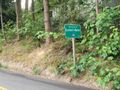
Summit-Waller @47.2181,-122.3725
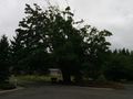
Wrong turn, cool tree @47.2027,-122.3637


