Difference between revisions of "2015-06-02 52 1"
From Geohashing
imported>Sourcerer (→Planning) |
imported>FippeBot m (Location) |
||
| (7 intermediate revisions by one other user not shown) | |||
| Line 3: | Line 3: | ||
| lon=1 | | lon=1 | ||
| date=2015-06-02 | | date=2015-06-02 | ||
| + | | graticule_name=Norwich, UK | ||
| + | | graticule_link=Norwich, United Kingdom | ||
}} | }} | ||
__NOTOC__ | __NOTOC__ | ||
| Line 21: | Line 23: | ||
== Expedition == | == Expedition == | ||
| + | *Arrived. -- [[User:Sourcerer|Sourcerer]] ([[User talk:Sourcerer|talk]]) [http://www.openstreetmap.org/?lat=52.36224532&lon=1.26616895&zoom=16&layers=B000FTF @52.3622,1.2662] 00:30, 2 June 2015 (GMT+01:00) | ||
| + | |||
| + | This went more or less to plan arriving 30 minutes late. The hashpoint was in a field of beans. Once I left the footpath, there were tractor tracks, easy to follow. | ||
| + | |||
| + | It was windy and there were rain showers but it wasn't cold. | ||
== Photos == | == Photos == | ||
<gallery perrow="5"> | <gallery perrow="5"> | ||
| + | Image:2015-06-02_52_1_Sourcerer_1433201388069.jpg | Proof. [http://www.openstreetmap.org/?lat=52.36224532&lon=1.26616895&zoom=16&layers=B000FTF @52.3622,1.2662] | ||
| + | Image:2015-06-02 52 1 Sourcerer.jpg | Google Earth Track Log | ||
</gallery> | </gallery> | ||
== Achievements == | == Achievements == | ||
{{#vardefine:ribbonwidth|800px}} | {{#vardefine:ribbonwidth|800px}} | ||
| + | {{Midnight geohash | ||
| + | | latitude = 52 | ||
| + | | longitude = 1 | ||
| + | | date = 2015-06-02 | ||
| + | | name = Sourcerer | ||
| + | }} | ||
| + | {{Sourcerer_links | ||
| + | | prev = 2015-06-01 52 1 | ||
| + | | curr = 2015-06-02 52 1 | ||
| + | | next = 2015-06-03 52 1 | ||
| + | | date = 2015-06-02 | ||
| + | }} | ||
| − | |||
| − | |||
| − | |||
| − | |||
| − | |||
| − | |||
[[Category:Expeditions]] | [[Category:Expeditions]] | ||
[[Category:Expeditions with photos]] | [[Category:Expeditions with photos]] | ||
[[Category:Coordinates reached]] | [[Category:Coordinates reached]] | ||
| − | + | {{location|GB|ENG|SFK}} | |
Latest revision as of 03:52, 15 August 2019
| Tue 2 Jun 2015 in Norwich, UK: 52.3622358, 1.2662186 geohashing.info google osm bing/os kml crox |
Location
Close to a public footpath near Brockdish, Suffolk, UK.
Participants
Plans
Expedition two of two spanning midnight. ETA 00:00. 2015-06-01 52 1 2015-06-02 52 1
The hashpoint is in a field close to a public right of way. Bad weather is forecast.
Expedition
- Arrived. -- Sourcerer (talk) @52.3622,1.2662 00:30, 2 June 2015 (GMT+01:00)
This went more or less to plan arriving 30 minutes late. The hashpoint was in a field of beans. Once I left the footpath, there were tractor tracks, easy to follow.
It was windy and there were rain showers but it wasn't cold.
Photos
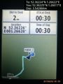
Proof. @52.3622,1.2662
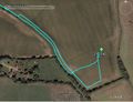
Google Earth Track Log


Achievements
Sourcerer earned the Midnight Geohash achievement
|
Expeditions and Plans
| 2015-06-02 | ||
|---|---|---|
| Seattle, Washington | Thomcat | On a driveway in the town of Summit-Waller, just south of Tacoma. |
| Norwich, United Kingdom | Sourcerer | Close to a public footpath near Brockdish, Suffolk, UK. |
| Utrecht, Netherlands | Chrunchstick | A gully in Almere Danswijk |
Sourcerer's Expedition Links
2015-06-01 52 1 - 2015-06-02 52 1 - 2015-06-03 52 1 - KML file download of Sourcerer's expeditions for use with Google Earth.