Difference between revisions of "2015-06-03 50 19"
imported>Malgond |
imported>FippeBot m (Location) |
||
| (19 intermediate revisions by one other user not shown) | |||
| Line 19: | Line 19: | ||
== Location == | == Location == | ||
| − | On the A4 motorway! Tally-ho! | + | On the A4 motorway! Tally-ho! The legal speed is 140 km/h. |
== Participants == | == Participants == | ||
| − | + | ||
| − | + | [[User:Malgond|Malgond]] and his son. | |
== Plans == | == Plans == | ||
| Line 29: | Line 29: | ||
According to Google Maps it's right on the A4 on the west-going lane, just after Balin junction. | According to Google Maps it's right on the A4 on the west-going lane, just after Balin junction. | ||
| + | <gallery perrow="5"> | ||
| + | Image:2015-06-03_50_19-location2.png | Location of hash on Google Maps | ||
| + | Image:2015-06-03_50_19-location1.png | Same at full zoom. | ||
| + | </gallery> | ||
| − | To have room to get up to speed I'll need to enter on the previous | + | To have room to get up to speed I'll need to enter on the previous Chrzanów junction and leave on the next one, named Byczyna. Even if it is technically a toll road, the payment is collected only at the start and at the end of the toll section of the route so in this way I can ride a few kilometers for free! |
| + | [[Image:2015-06-03_50_19-map.png|800px]] | ||
== Expedition == | == Expedition == | ||
| − | |||
| − | + | We have started late this day, approximately at 7 p.m. Sun was low already and I was afraid a bit it gets dark before we arrive. The weather was fair with scattered clouds which were getting more and more colors... | |
| − | |||
| − | |||
| − | |||
| − | |||
| − | |||
<gallery perrow="5"> | <gallery perrow="5"> | ||
| + | Image:2015-06-03_50_19-1.jpeg | Setting sun illuminates the clouds from below. | ||
| + | Image:2015-06-03_50_19-2.jpeg | A nice evening. | ||
| + | Image:2015-06-03_50_19-6.jpeg | Clouds are getting pink already. | ||
</gallery> | </gallery> | ||
| − | + | To avoid paying the toll for the motorway, we drove along a parallel road (route 780) up to the town of Babice, the we turned right towards the city of Chrzanów and the junction of the same name. | |
| − | |||
| − | |||
| + | <gallery perrow="5"> | ||
| + | Image:2015-06-03_50_19-3.jpeg | The town of Babice. First roadsign announcing the motorway. | ||
| + | Image:2015-06-03_50_19-4.jpeg | Follow the blue arrows... | ||
| + | Image:2015-06-03_50_19-5.jpeg | City of Chrzanów. One of many roundabouts. | ||
| + | Image:2015-06-03_50_19-7.jpeg | Leaving Chrzanów towards the motorway junction. | ||
| + | Image:2015-06-03_50_19-8.jpeg | The last turn before the overpass. | ||
| + | </gallery> | ||
| − | + | We've arrived at the junction from the southwest (see map above), joined the west-facing lane and sped towards the next junction, named Balin. My son have recorded a [http://kibel.hasiok.net/~piotras/2015-06-03_50_19_speed_racer.mp4 video], but the camera kept loosing focus for some reason (probably the operator's fault), so it is not of the highest quality. Then we've taken the [http://kibel.hasiok.net/~piotras/2015-06-03_50_19_exit.mp4 next exit]. | |
| − | |||
| − | |||
| − | < | + | <gallery perrow="5"> |
| + | Image:2015-06-03_50_19-9.png | Approaching the Balin junction. | ||
| + | Image:2015-06-03_50_19-10.png | We've driven right through it... | ||
| + | Image:2015-06-03_50_19-11.png | ...with the top legal speed! | ||
| + | Image:2015-06-03_50_19-12a.png | Proof by Google & Eupeodes. | ||
| + | </gallery> | ||
| − | [[Category: | + | == Achievements == |
| − | + | {{#vardefine:ribbonwidth|800px}} | |
| − | + | [[Category:Poland]] | |
[[Category:Expeditions]] | [[Category:Expeditions]] | ||
| − | + | [[Category:Coordinates reached]] | |
[[Category:Expeditions with photos]] | [[Category:Expeditions with photos]] | ||
[[Category:Expeditions with videos]] | [[Category:Expeditions with videos]] | ||
[[Category:Expedition without GPS]] | [[Category:Expedition without GPS]] | ||
| − | |||
| − | |||
| − | |||
| − | |||
| + | {{land geohash | ||
| + | | latitude = 50 | ||
| + | | longitude = 19 | ||
| + | | date = 2015-06-03 | ||
| + | | name = [[User:Malgond|Malgond]] | ||
| + | | image = 2015-06-03_50_19-10.png | ||
| + | }} | ||
| − | - | + | {{drag-along |
| − | + | | latitude = 50 | |
| − | -- | + | | longitude = 19 |
| − | + | | date = 2015-06-03 | |
| − | [[ | + | | name = [[User:Malgond|Malgond]] |
| − | + | | partner = his son | |
| − | + | | image = 2015-06-03_50_19-10.png | |
| − | + | }} | |
| − | + | {{No_batteries_geohash | |
| − | + | | latitude = 50 | |
| − | + | | longitude = 19 | |
| − | + | | date = 2015-06-03 | |
| − | [[ | + | | name = [[User:Malgond|Malgond]] |
| + | | image = 2015-06-03_50_19-10.png | ||
| + | }} | ||
| − | + | {{Speed racer | |
| + | | latitude = 50 | ||
| + | | longitude = 19 | ||
| + | | date = 2015-06-03 | ||
| + | | name = [[User:Malgond|Malgond]] | ||
| + | | image = 2015-06-03_50_19-11.png | ||
| + | | speed = 140 km/h | ||
| + | }} | ||
| + | {{location|PL|K|CH}} | ||
Latest revision as of 00:47, 6 August 2019
| Wed 3 Jun 2015 in 50,19: 50.1525477, 19.3884927 geohashing.info google osm bing/os kml crox |
Location
On the A4 motorway! Tally-ho! The legal speed is 140 km/h.
Participants
Malgond and his son.
Plans
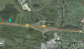
According to Google Maps it's right on the A4 on the west-going lane, just after Balin junction.
Location of hash on Google Maps
Same at full zoom.


To have room to get up to speed I'll need to enter on the previous Chrzanów junction and leave on the next one, named Byczyna. Even if it is technically a toll road, the payment is collected only at the start and at the end of the toll section of the route so in this way I can ride a few kilometers for free!

Expedition
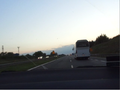
We have started late this day, approximately at 7 p.m. Sun was low already and I was afraid a bit it gets dark before we arrive. The weather was fair with scattered clouds which were getting more and more colors...
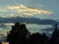
Setting sun illuminates the clouds from below.
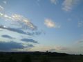
A nice evening.
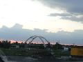
Clouds are getting pink already.


To avoid paying the toll for the motorway, we drove along a parallel road (route 780) up to the town of Babice, the we turned right towards the city of Chrzanów and the junction of the same name.
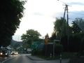
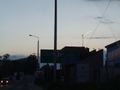
The town of Babice. First roadsign announcing the motorway.
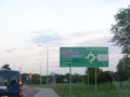
Follow the blue arrows...
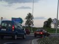
City of Chrzanów. One of many roundabouts.
Leaving Chrzanów towards the motorway junction.
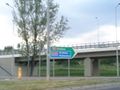
The last turn before the overpass.


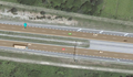
We've arrived at the junction from the southwest (see map above), joined the west-facing lane and sped towards the next junction, named Balin. My son have recorded a video, but the camera kept loosing focus for some reason (probably the operator's fault), so it is not of the highest quality. Then we've taken the next exit.
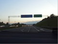
Approaching the Balin junction.
We've driven right through it...
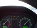
...with the top legal speed!
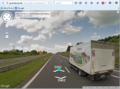
Proof by Google & Eupeodes.


Achievements
Malgond earned the Land geohash achievement
|
Malgond earned the Drag-along achievement
|
Malgond earned the No Batteries Geohash Achievement
|
