Difference between revisions of "2015-06-05 45 -122"
imported>Shmur (Created page with "{{subst:Expedition |lat = 45 |lon = -122 |date = 2015-06-05 }}") |
m |
||
| (9 intermediate revisions by 2 users not shown) | |||
| Line 18: | Line 18: | ||
__NOTOC__ | __NOTOC__ | ||
== Location == | == Location == | ||
| − | + | In a forest approximately 1km east of the end of SW Montgomery Way and 100m north of the north bank of the Willamette River, Wilsonville, Washington County, OR, USA. | |
== Participants == | == Participants == | ||
| − | + | * [[User:Shmur|Shmur]] | |
| − | |||
== Plans == | == Plans == | ||
| − | + | Leave work after lunch (hooray for summer hours on friday!) and drive south on I-5 towards Wilsonville. Take SW Montgomery road all the way to the end, park and hike through the forest to the geohash. | |
== Expedition == | == Expedition == | ||
| − | + | Hopped on 26 east around 1300, took 217 south to I-5 south and got off at exit 286. This ended up being a slightly different route, than I had planned. I would approach the geohash from the north, via SW 60th avenue. This ended up being a pretty interesting route. 60th Ave. started off as a regular road, then became a gravel road, and eventually became not a road at all, but just a grass path with tire tracks lined by blackberry bushes. I drove down this bumpy, overgrown non-road for about half of a mile before I came the to end. I got out of the car and poked around in the brush, but the forest seemed largely unpassable. I was only able to get within about 600 feet of the Geohash. At this point I turned around and left, figuring that the forest approach via Montgomery Way would also not be hikable, at least not without a machete to clear the brush out of the way. | |
== Tracklog == | == Tracklog == | ||
| Line 38: | Line 37: | ||
--> | --> | ||
<gallery perrow="5"> | <gallery perrow="5"> | ||
| + | Image:IMG_2754.jpg | Gravel road turns to grass path | ||
| + | Image:2015-06-05_Portland_GPS_Screenshot.jpg | Gaia GPS Screenshot | ||
| + | Image:2015-06-05_Path_End_Panorama.jpg | Thick forest ahead | ||
| + | Image:2015-06-05_Portland_Poor_Footwear.jpg | Should have worn boots. | ||
</gallery> | </gallery> | ||
| Line 44: | Line 47: | ||
<!-- Add any achievement ribbons you earned below, or remove this section --> | <!-- Add any achievement ribbons you earned below, or remove this section --> | ||
| − | |||
| − | |||
| − | |||
| − | |||
| − | |||
| − | |||
| − | |||
| − | |||
| − | |||
| − | |||
| − | |||
| − | |||
| − | |||
[[Category:Expeditions]] | [[Category:Expeditions]] | ||
| − | |||
| − | |||
| − | |||
| − | |||
| − | |||
| − | |||
| − | |||
| − | |||
| − | |||
| − | |||
| − | |||
[[Category:Coordinates not reached]] | [[Category:Coordinates not reached]] | ||
| − | |||
| − | |||
[[Category:Not reached - Mother Nature]] | [[Category:Not reached - Mother Nature]] | ||
| − | + | [[Category:Expeditions with photos]] | |
| − | + | {{location|US|OR|CC}} | |
| − | |||
| − | |||
| − | |||
| − | [[Category: | ||
| − | |||
| − | |||
| − | |||
| − | |||
| − | |||
Latest revision as of 10:07, 12 September 2021
| Fri 5 Jun 2015 in 45,-122: 45.3031515, -122.7379941 geohashing.info google osm bing/os kml crox |
Location
In a forest approximately 1km east of the end of SW Montgomery Way and 100m north of the north bank of the Willamette River, Wilsonville, Washington County, OR, USA.
Participants
Plans
Leave work after lunch (hooray for summer hours on friday!) and drive south on I-5 towards Wilsonville. Take SW Montgomery road all the way to the end, park and hike through the forest to the geohash.
Expedition
Hopped on 26 east around 1300, took 217 south to I-5 south and got off at exit 286. This ended up being a slightly different route, than I had planned. I would approach the geohash from the north, via SW 60th avenue. This ended up being a pretty interesting route. 60th Ave. started off as a regular road, then became a gravel road, and eventually became not a road at all, but just a grass path with tire tracks lined by blackberry bushes. I drove down this bumpy, overgrown non-road for about half of a mile before I came the to end. I got out of the car and poked around in the brush, but the forest seemed largely unpassable. I was only able to get within about 600 feet of the Geohash. At this point I turned around and left, figuring that the forest approach via Montgomery Way would also not be hikable, at least not without a machete to clear the brush out of the way.
Tracklog
Photos
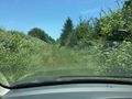
Gravel road turns to grass path
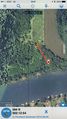
Gaia GPS Screenshot
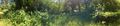
Thick forest ahead
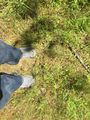
Should have worn boots.


