Difference between revisions of "2015-06-05 49 7"
imported>DODO (→Participants) |
imported>FippeBot m (Location) |
||
| (7 intermediate revisions by one other user not shown) | |||
| Line 28: | Line 28: | ||
== Plans == | == Plans == | ||
<!-- what were the original plans --> | <!-- what were the original plans --> | ||
| + | I have time for a hash this morning. Well, the nearest one is in Heidelberg, but it doesn't look reachable. The second nearest is - oh, thats's cool. It's in 49 7, a graticule still missing on my minesweeper-map. And it looks not only reachable but it's also close to a train station, so I can come home either. So I'll go there on my bull, and continue to Kaiserslautern main station. | ||
== Expedition == | == Expedition == | ||
<!-- how it all turned out. your narrative goes here. --> | <!-- how it all turned out. your narrative goes here. --> | ||
| + | Well, the lady has to work this morning and me not. What a great opportunity for a hash. And as I've already said,this is an important one for me. So, the Bull was well feed and so was I. There's not so much to tell about the way, I went through Neustadt, then through the Elmsteiner Tal, always near the Speyerbach, which flows into the Rhine river at Speyer. But then combat tells me to leaf the Speyerbach and the valley and ride into the forest. The further I got the less drivable got the way. Not only that it was very steep, but it was also very uneven and even with the support of the motor we couldn't get up and I had to push the bull (and going down would have been even worse). But in the end we did it. On the top of the hill we both need a rest and had to cool down (the motor send a heat warning since a while). | ||
| + | |||
| + | From here on the way was quite easy and 40 minutes later I stood on the way above the hash. The sound of swimming people clanged through the forested I climbed down through a very dense copse.I needed several attempts but finally I reached what I called "good enough". There must have been some hidden raptors to: I found several scratches on my legs and even one at my arm. Happy with my success I climbed back to my bull and rode back to the street. | ||
| + | |||
| + | Soon I reached the lake that I'd already heard in the forest. I hoped to get some food there, but to come to the restaurant you had to pay an entrance fee to the swimming bath. I didn't want to pay that for probably bad food and so I continued; and I was rewarded for that. Some kilometers later I found a very nice hotel where I got a great ice-cream with strawberries and some beer. Saturated like that I rode the last few kilometers to Kaiserslautern train station and got home an hour later. | ||
== Tracklog == | == Tracklog == | ||
<!-- if your GPS device keeps a log, you may post a link here --> | <!-- if your GPS device keeps a log, you may post a link here --> | ||
| + | [https://www.komoot.de/tour/5269521 88 KM bullriding] and here [http://www.gpsies.com/map.do?fileId=fpdebrpicoioxdpx the 88 KM riding and 55KM train] | ||
== Photos == | == Photos == | ||
| Line 40: | Line 47: | ||
--> | --> | ||
<gallery perrow="5"> | <gallery perrow="5"> | ||
| + | Image:2015-06-05_49_7-2.jpg|view from the way down to the hash | ||
| + | Image:2015-06-05_49_7-1.jpg|hash-ants | ||
| + | Image:2015-06-05_49_7-3.jpg|best proof I got | ||
| + | Image:2015-06-05_49_7-4.jpg|view to one direction (don't know the cardinal direction) | ||
| + | Image:2015-06-05_49_7-5.jpg|and to the other direction | ||
| + | Image:2015-06-05_49_7-6.jpg|exhausted but happy hasher | ||
| + | Image:2015-06-05_49_7-7.jpg|back at my bulls side | ||
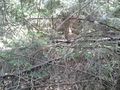
| + | Image:2015-06-05_49_7-8.jpg|raptors | ||
| + | Image:2015-06-05_49_7-9.jpg|gratification | ||
</gallery> | </gallery> | ||
== Achievements == | == Achievements == | ||
{{#vardefine:ribbonwidth|800px}} | {{#vardefine:ribbonwidth|800px}} | ||
| − | |||
| + | {{land geohash | ||
| + | | latitude = 49 | ||
| + | | longitude = 7 | ||
| + | | date = 2015-06-05 | ||
| + | | name = DODO | ||
| + | }} | ||
| − | + | {{consecutive geohash | |
| − | + | | count = 2 | |
| − | + | | latitude = 49 | |
| + | | longitude = 8 | ||
| + | | date = 2015-06-04 | ||
| + | | name = DODO | ||
| + | }} | ||
| − | + | {{Velociraptor geohash | |
| + | | latitude = 49 | ||
| + | | longitude = 7 | ||
| + | | date = 2015-06-05 | ||
| + | | name = DODO | ||
| + | | image = 2015-06-05 49 7-8.jpg | ||
| − | + | }} | |
| − | + | ||
| − | + | {{Minesweeper geohash | |
| − | + | | graticule = Mannheim, Germany | |
| + | | ranknumber = 7 | ||
| + | | nw = true | ||
| + | | w = true | ||
| + | | sw = true | ||
| + | | n = true | ||
| + | | s = true | ||
| + | | e = true | ||
| + | | se=true | ||
| + | | name = DODO | ||
| + | }} | ||
| + | |||
| + | {{OpenStreetMap achievement | ||
| + | | latitude = 49 | ||
| + | | longitude = 7 | ||
| + | | date = 2015-06-05 | ||
| + | | OSMlink = 31799385 | ||
| + | | name = DODO | ||
| + | }} | ||
| − | |||
[[Category:Expeditions]] | [[Category:Expeditions]] | ||
| − | |||
| − | |||
| − | |||
| − | |||
| − | |||
| − | |||
| − | |||
[[Category:Coordinates reached]] | [[Category:Coordinates reached]] | ||
| − | + | {{location|DE|RP|KL}} | |
| − | |||
| − | |||
| − | |||
| − | |||
| − | |||
| − | |||
| − | |||
| − | |||
| − | |||
| − | |||
| − | |||
| − | |||
| − | |||
| − | |||
| − | |||
| − | |||
| − | |||
Latest revision as of 01:02, 7 August 2019
| Fri 5 Jun 2015 in 49,7: 49.3938772, 7.6864041 geohashing.info google osm bing/os kml crox |
Location
In the forest above the lake Gelterswoog near Kaiserslautern.
Participants
Plans
I have time for a hash this morning. Well, the nearest one is in Heidelberg, but it doesn't look reachable. The second nearest is - oh, thats's cool. It's in 49 7, a graticule still missing on my minesweeper-map. And it looks not only reachable but it's also close to a train station, so I can come home either. So I'll go there on my bull, and continue to Kaiserslautern main station.
Expedition
Well, the lady has to work this morning and me not. What a great opportunity for a hash. And as I've already said,this is an important one for me. So, the Bull was well feed and so was I. There's not so much to tell about the way, I went through Neustadt, then through the Elmsteiner Tal, always near the Speyerbach, which flows into the Rhine river at Speyer. But then combat tells me to leaf the Speyerbach and the valley and ride into the forest. The further I got the less drivable got the way. Not only that it was very steep, but it was also very uneven and even with the support of the motor we couldn't get up and I had to push the bull (and going down would have been even worse). But in the end we did it. On the top of the hill we both need a rest and had to cool down (the motor send a heat warning since a while).
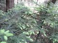
From here on the way was quite easy and 40 minutes later I stood on the way above the hash. The sound of swimming people clanged through the forested I climbed down through a very dense copse.I needed several attempts but finally I reached what I called "good enough". There must have been some hidden raptors to: I found several scratches on my legs and even one at my arm. Happy with my success I climbed back to my bull and rode back to the street.
Soon I reached the lake that I'd already heard in the forest. I hoped to get some food there, but to come to the restaurant you had to pay an entrance fee to the swimming bath. I didn't want to pay that for probably bad food and so I continued; and I was rewarded for that. Some kilometers later I found a very nice hotel where I got a great ice-cream with strawberries and some beer. Saturated like that I rode the last few kilometers to Kaiserslautern train station and got home an hour later.
Tracklog
88 KM bullriding and here the 88 KM riding and 55KM train
Photos
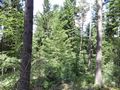
view from the way down to the hash
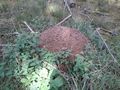
hash-ants
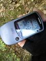
best proof I got
view to one direction (don't know the cardinal direction)
and to the other direction
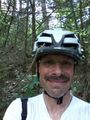
exhausted but happy hasher
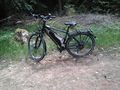
back at my bulls side
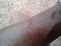
raptors
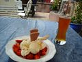
gratification


Achievements
DODO earned the Land geohash achievement
|
DODO earned the Consecutive geohash achievement
|
DODO earned the Velociraptor Geohash Achievement
|
DODO achieved level 7 of the Minesweeper Geohash achievement
|
DODO earned the OpenStreetMap achievement
|