Difference between revisions of "2015-06-28 52 1"
From Geohashing
imported>Sourcerer m (→Expedition updated) |
m |
||
| (3 intermediate revisions by 2 users not shown) | |||
| Line 3: | Line 3: | ||
| lon=1 | | lon=1 | ||
| date=2015-06-28 | | date=2015-06-28 | ||
| + | | graticule_name=Norwich, UK | ||
| + | | graticule_link=Norwich, United Kingdom | ||
}} | }} | ||
__NOTOC__ | __NOTOC__ | ||
| Line 17: | Line 19: | ||
Expedition one of two spanning midnight. [[2015-06-28 52 1]] - [[2015-06-29 51 0]] - ETA 23:00. | Expedition one of two spanning midnight. [[2015-06-28 52 1]] - [[2015-06-29 51 0]] - ETA 23:00. | ||
| − | == Expedition == | + | == Expedition - Fail == |
It was a mild moonlit summer evening. There was an impenetrable crop of oil seed rape. I found some tractor tracks but these were not leading close enough. I could not reach the point without doing damage. Indeed the plants had grown so well that the hashpoint was virtually unreachable even with damage. My closest approach was 40 metres. | It was a mild moonlit summer evening. There was an impenetrable crop of oil seed rape. I found some tractor tracks but these were not leading close enough. I could not reach the point without doing damage. Indeed the plants had grown so well that the hashpoint was virtually unreachable even with damage. My closest approach was 40 metres. | ||
| Line 38: | Line 40: | ||
[[Category:Expeditions with photos]] | [[Category:Expeditions with photos]] | ||
[[Category:Coordinates not reached]] | [[Category:Coordinates not reached]] | ||
| + | [[Category:Not reached - No public access]] | ||
| + | {{location|GB|ENG|SFK}} | ||
Latest revision as of 09:38, 28 March 2022
| Sun 28 Jun 2015 in Norwich, UK: 52.1041680, 1.1525844 geohashing.info google osm bing/os kml crox |
Location
A few paces into a field east of Claydon, Suffolk, UK.
Participants
Plans
Expedition one of two spanning midnight. 2015-06-28 52 1 - 2015-06-29 51 0 - ETA 23:00.
Expedition - Fail
It was a mild moonlit summer evening. There was an impenetrable crop of oil seed rape. I found some tractor tracks but these were not leading close enough. I could not reach the point without doing damage. Indeed the plants had grown so well that the hashpoint was virtually unreachable even with damage. My closest approach was 40 metres.
Photos
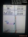
Can't reach the point without crop damage. @52.1042,1.1534
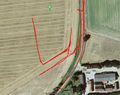
Track Log in Google Earth


Expeditions and Plans
| 2015-06-28 | ||
|---|---|---|
| Schaumburg, Illinois | Gefrierbrand | Near a pond in the Crabtree Nature Preserve. |
| Pforzheim, Germany | RecentlyChanged, younger sister, older sister | Briglerain/Brücklerain? On the side of a hill |
| Kraków, Poland | Malgond | On the bank of a stream in Goławiec, Poland. |
| Goslar, Germany | GeorgDerReisende | The hash lay in a dry ditch near Rambach. |
| Norwich, United Kingdom | Sourcerer | A few paces into a field east of Claydon, Suffolk, UK. |
Sourcerer's Expedition Links
2015-06-27 52 0 - 2015-06-28 52 1 - 2015-06-29 51 0 - KML file download of Sourcerer's expeditions for use with Google Earth.