2015-06-27 52 0
| Sat 27 Jun 2015 in Cambridge, UK: 52.0363287, 0.6466410 geohashing.info google osm bing/os kml crox |
Location
In a field north of Belchamp Walter, Essex, UK.
Participants
Plans
This was not really planned. I realised it was not too far from 2015-06-26 51 1 so I took in this point on my way home.
Expedition
Driving from Suffolk to Essex, there were wonderful cloudscapes. The sun had set long before and the low clouds were very black. Above, there was an iridescent blue blow. This might have been the rare phenomenon of noctilucent cloud. There are nice examples on Google Images.
- Arrived. -- Sourcerer (talk) @52.0363,.6466 00:01, 27 June 2015 (GMT+01:00)
It was possible to park at the village hall. A public footpath headed north but quickly faded to nothing. More stepping between sugar beet plants was needed. Then there were a few metres of oil seed rape to force my way through to zero the distance. I arrived just before midnight and had to wait in the mild breeze for the day to increment. I only ever force my way through crops if there is supposed to be a path but the farmer has not marked it. Today was a good example.
Photos
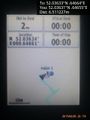
Proof. @52.0363,.6466
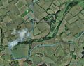
Google Earth Track Log


Achievements
Sourcerer earned the Midnight Geohash achievement
|
Sourcerer earned the OpenStreetMap achievement
|
Sourcerer earned the Two to the N achievement
|
Expeditions and Plans
| 2015-06-27 | ||
|---|---|---|
| Cambridge, United Kingdom | Sourcerer | In a field north of Belchamp Walter, Essex, UK. |
| Blyth, United Kingdom | Feyrob | Somewhere |
Sourcerer's Expedition Links
2015-06-26 51 1 - 2015-06-27 52 0 - 2015-06-28 52 1 - KML file download of Sourcerer's expeditions for use with Google Earth.