Difference between revisions of "2015-06-29 51 0"
From Geohashing
imported>Sourcerer m ([live] Arrived.) |
imported>FippeBot m (Location) |
||
| (7 intermediate revisions by one other user not shown) | |||
| Line 3: | Line 3: | ||
| lon=0 | | lon=0 | ||
| date=2015-06-29 | | date=2015-06-29 | ||
| + | | graticule_name=London East, UK | ||
| + | | graticule_link=London East, United Kingdom | ||
}} | }} | ||
__NOTOC__ | __NOTOC__ | ||
== Location == | == Location == | ||
| − | + | 1) Very close to a public footpath, Nayland, Suffolk, UK. | |
== Participants == | == Participants == | ||
| Line 19: | Line 21: | ||
== Expedition == | == Expedition == | ||
| + | *Arrived. -- [[User:Sourcerer|Sourcerer]] ([[User talk:Sourcerer|talk]]) [http://www.openstreetmap.org/?lat=51.97362006&lon=.86707234&zoom=16&layers=B000FTF @51.9736,.8671] 00:12, 29 June 2015 (GMT+01:00) | ||
| + | |||
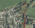
| + | There was a public footpath into parkland and a children's play area. In the north west corner there was a hole in the low fence giving access to the hashpoint. There was some doubt whether the point was in a garden or in the meadow on my side of the fence. Geohash droid had turned green and said I'd arrived so I'll claim this one. | ||
| + | Then I walked the footpath a bit further so I can add it to OpenStreetMap. | ||
| − | |||
== Photos == | == Photos == | ||
<gallery perrow="5"> | <gallery perrow="5"> | ||
| + | Image:2015-06-29_51_0_Sourcerer_1435533127849.jpg | Proof. [http://www.openstreetmap.org/?lat=51.97362542&lon=.86709380&zoom=16&layers=B000FTF @51.9736,.8671] | ||
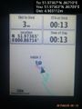
| + | Image:2015-06-29 51 0 Sourcerer.jpg | Track Log in Google Earth | ||
</gallery> | </gallery> | ||
== Achievements == | == Achievements == | ||
{{#vardefine:ribbonwidth|800px}} | {{#vardefine:ribbonwidth|800px}} | ||
| − | {{ | + | {{Midnight geohash |
| − | + | | latitude = 51 | |
| − | | latitude = | + | | longitude = 0 |
| − | | longitude = | + | | date = 2015-06-29 |
| − | | date = 2015-06- | ||
| name = Sourcerer | | name = Sourcerer | ||
}} | }} | ||
| − | {{ | + | {{OpenStreetMap achievement |
| latitude = 51 | | latitude = 51 | ||
| longitude = 0 | | longitude = 0 | ||
| date = 2015-06-29 | | date = 2015-06-29 | ||
| + | | OSMlink = 32274468 | ||
| name = Sourcerer | | name = Sourcerer | ||
}} | }} | ||
| Line 46: | Line 53: | ||
| prev = 2015-06-28 52 1 | | prev = 2015-06-28 52 1 | ||
| curr = 2015-06-29 51 0 | | curr = 2015-06-29 51 0 | ||
| + | | next = 2015-06-29 52 0 | ||
| date = 2015-06-29 | | date = 2015-06-29 | ||
}} | }} | ||
| − | |||
| − | |||
[[Category:Expeditions]] | [[Category:Expeditions]] | ||
[[Category:Expeditions with photos]] | [[Category:Expeditions with photos]] | ||
[[Category:Coordinates reached]] | [[Category:Coordinates reached]] | ||
| − | + | {{location|GB|ENG|SFK}} | |
Latest revision as of 04:11, 15 August 2019
| Mon 29 Jun 2015 in London East, UK: 51.9736694, 0.8670989 geohashing.info google osm bing/os kml crox |
Location
1) Very close to a public footpath, Nayland, Suffolk, UK.
Participants
Plans
Expedition two of two spanning midnight. 2015-06-28 52 1 - 2015-06-29 51 0 - ETA 00:00.
Expedition
- Arrived. -- Sourcerer (talk) @51.9736,.8671 00:12, 29 June 2015 (GMT+01:00)
There was a public footpath into parkland and a children's play area. In the north west corner there was a hole in the low fence giving access to the hashpoint. There was some doubt whether the point was in a garden or in the meadow on my side of the fence. Geohash droid had turned green and said I'd arrived so I'll claim this one.
Then I walked the footpath a bit further so I can add it to OpenStreetMap.
Photos
Proof. @51.9736,.8671
Track Log in Google Earth


Achievements
Sourcerer earned the Midnight Geohash achievement
|
Sourcerer earned the OpenStreetMap achievement
|
Expeditions and Plans
| 2015-06-29 | ||
|---|---|---|
| London East, United Kingdom | Sourcerer | 1) Very close to a public footpath, Nayland, Suffolk, UK. |
| Kassel, Germany | GeorgDerReisende | The hash lies in the main street of Alfeld-Hörsum. |
| Cambridge, United Kingdom | Sourcerer | 2) On the mud flats north of Wells Next the Sea, Norfolk, UK. |
Sourcerer's Expedition Links
2015-06-28 52 1 - 2015-06-29 51 0 - 2015-06-29 52 0 - KML file download of Sourcerer's expeditions for use with Google Earth.