2015-06-29 52 0
| Mon 29 Jun 2015 in 52,0: 52.9736694, 0.8670989 geohashing.info google osm bing/os kml crox |
Location
On the mud flats north of Wells Next the Sea, Norfolk, UK.
Participants
Plans
Leave home at 17:00. Park at about 18:50. Walk for 2:15 to the hashpoint arriving at about 21:00. Walk back another 2:15. Drive for 30 minutes and walk to 2015-06-30 52 0.
I'll start walking about one hour after high tide and will follow the water line as the tide recedes. I might be delayed if the creek wades are still too deep. On my return, the tide should be low, giving a wide safety margin. The moon is nearly full and the weather likely to be clear and mild so there should be good light. Even so, this expedition is riskier than most being over two hours walk from dry land, at night and on tidal sands and mud. I made a similar expedition in daylight on 2011-06-26 52 0.
Expedition
- Arrived. -- Sourcerer (talk) @52.9737,.8671 21:24, 29 June 2015 (GMT+01:00)
Photos
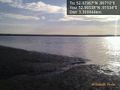
Tide is still too high. @52.9654,.9153

Achievements
Expeditions and Plans
| 2015-06-29 | ||
|---|---|---|
| London East, United Kingdom | Sourcerer | 1) Very close to a public footpath, Nayland, Suffolk, UK. |
| Kassel, Germany | GeorgDerReisende | The hash lies in the main street of Alfeld-Hörsum. |
| Cambridge, United Kingdom | Sourcerer | 2) On the mud flats north of Wells Next the Sea, Norfolk, UK. |
Sourcerer's Expedition Links
2015-06-29 51 0 - 2015-06-29 52 0 - 2015-06-30 52 0 - KML file download of Sourcerer's expeditions for use with Google Earth.