2011-06-26 52 0
| Sun 26 Jun 2011 in Cambridge: 52.9888553, 0.8545154 geohashing.info google osm bing/os kml crox |
Contents
[hide]Location
On the mud and sand flats quite a long way off shore, north of Wells Next the Sea, Norfolk, UK. Logged at Wikiloc.
Participants
Expedition Plans
This location can only be reached at low tide and depending on the shifting sands, perhaps not even then. The BBC tide table shows 09:29 or 21:12 as the best times. The walk from a car park in Stiffkey to the hashpoint will be about ten miles total. Eight miles will be on the sand and mud flats. The weather forecast is for the hottest day of the year reaching 31 or 32C. I plan to set out walking at 07:30. If the hash is reachable, I'll arrive at low tide and return by 11:30. The failure modes include:
- Terrain - Creeks are too deep to wade.
- Access Restrictions - This is a nature reserve and public access may be banned during the bird nesting season. I would certainly respect this restriction.
- Mud - Past experience suggests that this will not stop me. Getting covered with stinking anaerobic mud is fun! I just hope there's a place to wash off before returning to civilisation.
If this plan fails, it may be possible to reach the hash from Wells next the Sea. The walk is shorter but the creek wade is much deeper.
This is my favourite type of geohashing expedition. There is wild terrain, some minor danger requiring detailed planning and careful observation during the trek and a real possibility of failure.
Success or failure will be rewarded by lunch at the Victoria Hotel, Holkham where they barbecue home reared beef with venison burgers and sausages. They have nice beer too, sadly at special treat prices.
The Expedition
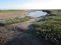
This went more or less to plan. The 4am alarm worked. I reached the north Norfolk coast just after 6am. The whole walk took 5.5 hours. The first creek was too deep to wade so I headed up-stream to a shallower place. This also explains the geoflash. There was no public indecency as there was no public! Wet clothes are not nice so it's safer to strip off for the deeper paddles. Next, the direct path was blocked by a bird nesting site so a small detour was needed. Now walking bare foot, it was a more or less direct path to the hashpoint, only dodging the more stony areas. Near the hashpoint there was a 20 minute dramatic build-up. The channel marker buoys could be seen from miles away. Was the hash on land or in the middle of the harbour access channel? At about the 200 metre mark, it became clear that the point was reachable so it was a close thing. The walk so far was 9.1 km or about 5.5 miles. On the outward leg, I saw one dog walker on the north coast path.
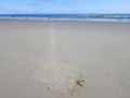
On the return leg, I passed one man about 100 metres away. He was heading towards the hashpoint but had no GPS and he'd left it too late because of the incoming tide. So he was not a geohasher. Crossing the last and biggest creek, I tested the water-proofing of my camera and GPS by slipping on the mud and ending up on all fours in the water. Both devices were water proof when new and both seem to be fine. The GPS kept logging but when I checked the battery compartment, the micro-sd card self-ejected. Luckily I spotted this and re-inserted it. The device did not crash and the log looks just fine.
By 11:30 on the return leg, just as I was nearing the end of my expedition, some normal people were arriving at the beach. Of course they had left it too late to see the seals who head off-shore as soon as people appear.
I skipped the venison burgers having eaten cheese sandwiches on home made bread. The cash saved will pay for petrol for the next expedition.
18.2 km or 11.3 miles on foot in 5.5 hours.
Geohashers get ...
- a nice drive on completely empty roads.
- to see red deer.
- to see seals
- a walk on a deserted beach.
- sunburned feet and some other parts that are exposed less often.
- nice smooth exfoliated feet.
Normal people
- stay in bed
- drive on congested roads
- see some daytime TV
Photo Gallery
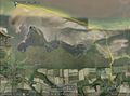
Google Earth Track
Public Footpath to Coast
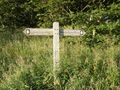
Coastal Walk Signposts
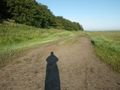
Giant Condom - Oops no it's my shadow!
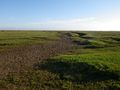
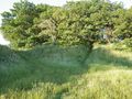
Salt Marshes
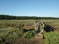
Bridge over a muddy creek
Salt Marshes
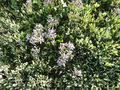
Sea Lavender
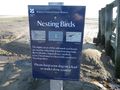
Nesting Birds Sign
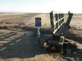
Another Bridge
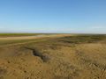
Mud Flats
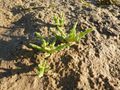
Samphire (Salicornia Europea) Edible, tasty but salty.
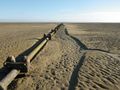
Disused Sewage Pipe
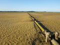
Disused Sewage Pipe
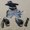
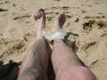
Geoflash Evidence
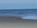
Seal
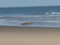
Seal escaping into the sea
Seal Tracks
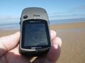
Destination Reached
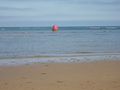
Wells Next the Sea Harbour Marker Buoys
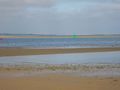
Wells Next the Sea Harbour Marker Buoys
Not Quite a Hobbit Achievement


Achievements
Sourcerer earned the Geoflashing Achievement
|
Expeditions and Plans
| 2011-06-26 | ||
|---|---|---|
| Auckland, New Zealand | Llama | Papatoetoe |
| Sebring, Florida | Rhonda | Circle B Bar Nature Reserve, in some trees off a trail. May or may not be a... |
| Buffalo, New York | Gefell | The trip went well, it turned out to be an industrial looking building that... |
| Portland, Oregon | Jim | Near Deer Island, Oregon out in Columbia River |
| Mannheim, Germany | Mampfred, LadyBB | On a field near Rodgau. |
| Erfurt, Germany | Juja, Hans | Near a fieldway on the Edge of Törpla - a village in the middle of nothing.... |
| Cambridge, United Kingdom | Sourcerer | On the mud and sand flats quite a long way off shore, north of Wells Next t... |
| Oslo, Norway | eiggen, ha | In the Lillomarka forest, close to Grorud, Oslo, Norway. |
Sourcerer's Expedition Links
2011-06-18 51 -1 - 2011-06-26 52 0 - 2011-06-29 52 1 - KML file download of Sourcerer's expeditions for use with Google Earth.