Difference between revisions of "2015-07-06 39 -89"
imported>Mystrsyko |
imported>FippeBot m (Location) |
||
| (One intermediate revision by one other user not shown) | |||
| Line 17: | Line 17: | ||
== Expedition == | == Expedition == | ||
| − | + | [[File:2015-07-06 39 -89 grin.jpg|200px|thumb|left|Another successful expedition!]] | |
| + | Once again I have been blessed with a remarkably close geohash along Veteran's Parkway, this one a 1/4 mile closer than the [[2015-05-28 39 -89|2015-05-28]] hash. This one wasn't in the brush on the side of the road, however. It was smack in the middle of the grassy median that separates the different directions of traffic. On a busy, high speed (55mph) highway, that makes for a rather dangerous flavor of geohashing. | ||
| + | |||
| + | Normally on my bike rides I wear bright "high visibility" yellow to ensure I'm seen by drivers easily. Today, that was especially important, given that I would be running around a busy road. I packed my ID card in case the police were to object to geohashers wandering around in the road and my hashscot Collin and made the short ride down the shoulder to the vicinity of the point. A road sign conveniently across the road from the point made a handy bicycle rest. | ||
| + | |||
| + | While assessing the traffic flow, I took some quick pictures of the area, and at a break in said traffic quickly made my way into the median. I wasted no time in jogging towards the hash and catching a quick screenshot as I passed it. Then a short wait for another gap in traffic and I was back across to my bike having spent no more than 60 seconds in the median. Any longer would have been both very dangerous and quite suspicious I imagine. | ||
| + | |||
| + | Not knowing if any of the drivers passing by were concerned enough to call the police, I decided not to wait and find out, and quickly was on my way home with another geohash under my belt. | ||
| + | |||
| + | |||
| + | |||
== Tracklog == | == Tracklog == | ||
| − | + | [https://www.strava.com/activities/340383897 Strava] | |
== Photos == | == Photos == | ||
| − | < | + | |
| − | Image: | + | <gallery widths="200px" heights="175px" perrow="5"> |
| − | -- | + | Image:2015-07-06 39 -89 hash.jpg|The approximate location of the hash |
| − | + | Image:2015-07-06 39 -89 north.jpg|View to the north | |
| + | Image:2015-07-06 39 -89 south.jpg|Surprisingly traffic free view south | ||
| + | Image:2015-07-06 39 -89 bike.jpg|Average traffic volume behind the bike | ||
| + | Image:2015-07-06 39 -89 screenshot.png|Proof on the run | ||
</gallery> | </gallery> | ||
== Achievements == | == Achievements == | ||
{{#vardefine:ribbonwidth|800px}} | {{#vardefine:ribbonwidth|800px}} | ||
| − | + | {{bicycle geohash | |
| − | + | | latitude = 39 | |
| − | + | | longitude = -89 | |
| − | + | | date = 2015-07-06 | |
| + | | name = Mystrsyko | ||
| + | | distance = 3.6 miles | ||
| + | | bothways = true | ||
| + | }} | ||
| + | {{land geohash | ||
| − | + | | latitude = 39 | |
| − | + | | longitude = -89 | |
| − | + | | date = 2015-07-06 | |
| − | + | | name = Mystrsyko | |
| + | }} | ||
| − | |||
| − | |||
[[Category:Expeditions]] | [[Category:Expeditions]] | ||
| − | |||
[[Category:Expeditions with photos]] | [[Category:Expeditions with photos]] | ||
| − | |||
| − | |||
| − | |||
| − | |||
| − | |||
[[Category:Coordinates reached]] | [[Category:Coordinates reached]] | ||
| − | + | {{location|US|IL|SM}} | |
| − | |||
| − | |||
| − | |||
| − | |||
| − | |||
| − | |||
| − | |||
| − | |||
| − | |||
| − | |||
| − | |||
| − | |||
| − | |||
| − | |||
| − | |||
| − | |||
| − | |||
Latest revision as of 04:16, 15 August 2019
| Mon 6 Jul 2015 in 39,-89: 39.8141484, -89.7029164 geohashing.info google osm bing/os kml crox |
Location
In the median of Veteran's Parkway, in Springfield
Participants
Plans
Bike out around noon
Expedition

Once again I have been blessed with a remarkably close geohash along Veteran's Parkway, this one a 1/4 mile closer than the 2015-05-28 hash. This one wasn't in the brush on the side of the road, however. It was smack in the middle of the grassy median that separates the different directions of traffic. On a busy, high speed (55mph) highway, that makes for a rather dangerous flavor of geohashing.
Normally on my bike rides I wear bright "high visibility" yellow to ensure I'm seen by drivers easily. Today, that was especially important, given that I would be running around a busy road. I packed my ID card in case the police were to object to geohashers wandering around in the road and my hashscot Collin and made the short ride down the shoulder to the vicinity of the point. A road sign conveniently across the road from the point made a handy bicycle rest.
While assessing the traffic flow, I took some quick pictures of the area, and at a break in said traffic quickly made my way into the median. I wasted no time in jogging towards the hash and catching a quick screenshot as I passed it. Then a short wait for another gap in traffic and I was back across to my bike having spent no more than 60 seconds in the median. Any longer would have been both very dangerous and quite suspicious I imagine.
Not knowing if any of the drivers passing by were concerned enough to call the police, I decided not to wait and find out, and quickly was on my way home with another geohash under my belt.
Tracklog
Photos
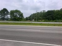
The approximate location of the hash
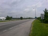
View to the north
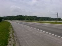
Surprisingly traffic free view south
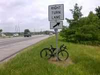
Average traffic volume behind the bike
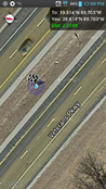
Proof on the run


Achievements
Mystrsyko earned the Bicycle geohash achievement
|
Mystrsyko earned the Land geohash achievement
|