Difference between revisions of "2015-07-06 52 1"
imported>Sourcerer m ([live] Arrived.) |
imported>FippeBot m (Location) |
||
| (6 intermediate revisions by one other user not shown) | |||
| Line 3: | Line 3: | ||
| lon=1 | | lon=1 | ||
| date=2015-07-06 | | date=2015-07-06 | ||
| + | | graticule_name=Norwich, UK | ||
| + | | graticule_link=Norwich, United Kingdom | ||
}} | }} | ||
__NOTOC__ | __NOTOC__ | ||
| Line 15: | Line 17: | ||
== Plans == | == Plans == | ||
| − | Combine this with [[2015-07-05 52 0]] but there will be some waiting about to do. I have to complete [[2015-07-05 52 0]] | + | Combine this with [[2015-07-05 52 0]] but there will be some waiting about to do. I have to complete [[2015-07-05 52 0]] before high tide and then wait till midnight. |
== Expedition == | == Expedition == | ||
| + | *Arrived. -- [[User:Sourcerer|Sourcerer]] ([[User talk:Sourcerer|talk]]) [http://www.openstreetmap.org/?lat=52.93881834&lon=1.25349283&zoom=16&layers=B000FTF @52.9388,1.2535] 00:00, 6 July 2015 (GMT+01:00) | ||
| + | This went to plan. I had to wait about 50 minutes. I found a shop, open late to get a snack. My energy was depleted and it had turned cool. I warmed up nicely after the food. At about 23:30 I set out walking to find the hashpoint. I found a footpath and then tractor tracks. I was in the wrong tracks but was able to correct this at the field perimeter by doubling back. At the field perimeter, my socks became stuck full of those hooked grass seeds. I got to within 5 metres of the hashpoint and didn't bother to zero the distance. I would have damaged the barley. Returning to the car via the cliff top path, I de-seeded my socks by torchlight, multitasking so I didn't veer over the cliff edge. | ||
| − | |||
== Photos == | == Photos == | ||
<gallery perrow="5"> | <gallery perrow="5"> | ||
| + | Image:2015-07-06_52_1_Sourcerer_1436137144881.jpg | Proof. [http://www.openstreetmap.org/?lat=52.93881834&lon=1.25349283&zoom=16&layers=B000FTF @52.9388,1.2535] | ||
| + | Image:2015-07-06 52 1 Sourcerer.jpg | Track in Google Earth | ||
</gallery> | </gallery> | ||
== Achievements == | == Achievements == | ||
{{#vardefine:ribbonwidth|800px}} | {{#vardefine:ribbonwidth|800px}} | ||
| + | {{Midnight geohash | ||
| + | | latitude = 52 | ||
| + | | longitude = 1 | ||
| + | | date = 2015-07-06 | ||
| + | | name = Sourcerer | ||
| + | }} | ||
{{Sourcerer_links | {{Sourcerer_links | ||
| Line 37: | Line 48: | ||
}} | }} | ||
| − | |||
| − | |||
[[Category:Expeditions]] | [[Category:Expeditions]] | ||
[[Category:Expeditions with photos]] | [[Category:Expeditions with photos]] | ||
[[Category:Coordinates reached]] | [[Category:Coordinates reached]] | ||
| − | + | {{location|GB|ENG|NFK}} | |
Latest revision as of 04:17, 15 August 2019
| Mon 6 Jul 2015 in Norwich, UK: 52.9388200, 1.2536000 geohashing.info google osm bing/os kml crox |
Location
In a field near the marine cliffs, West Runton, Norfolk, UK.
Participants
Plans
Combine this with 2015-07-05 52 0 but there will be some waiting about to do. I have to complete 2015-07-05 52 0 before high tide and then wait till midnight.
Expedition
- Arrived. -- Sourcerer (talk) @52.9388,1.2535 00:00, 6 July 2015 (GMT+01:00)
This went to plan. I had to wait about 50 minutes. I found a shop, open late to get a snack. My energy was depleted and it had turned cool. I warmed up nicely after the food. At about 23:30 I set out walking to find the hashpoint. I found a footpath and then tractor tracks. I was in the wrong tracks but was able to correct this at the field perimeter by doubling back. At the field perimeter, my socks became stuck full of those hooked grass seeds. I got to within 5 metres of the hashpoint and didn't bother to zero the distance. I would have damaged the barley. Returning to the car via the cliff top path, I de-seeded my socks by torchlight, multitasking so I didn't veer over the cliff edge.
Photos
Proof. @52.9388,1.2535
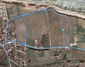
Track in Google Earth


Achievements
Sourcerer earned the Midnight Geohash achievement
|
Expeditions and Plans
| 2015-07-06 | ||
|---|---|---|
| Springfield, Illinois | Mystrsyko | In the median of Veteran's Parkway, in Springfield |
| Buffalo, New York | Pedalpusher | Behind shared parking lot for the Southtowns YMCA and Ismailia Shrine Templ... |
| Norwich, United Kingdom | Sourcerer | In a field near the marine cliffs, West Runton, Norfolk, UK. |
| Hannover, Germany | GeorgDerReisende | The hash lies in the forest of Verden near the street Uhlenmühlen. |
Sourcerer's Expedition Links
2015-07-05 52 0 - 2015-07-06 52 1 - 2015-07-07 52 1 - KML file download of Sourcerer's expeditions for use with Google Earth.