Difference between revisions of "2015-07-14 47 -122"
imported>Thomcat ([live picture] [http://www.openstreetmap.org/?lat=47.84329826&lon=-122.32496485&zoom=16&layers=B000FTF @47.8433,-122.3250]) |
imported>FippeBot m (Location) |
||
| (4 intermediate revisions by one other user not shown) | |||
| Line 1: | Line 1: | ||
| + | {{Advert}} | ||
| + | |||
{{meetup graticule | {{meetup graticule | ||
| lat=47 | | lat=47 | ||
| Line 18: | Line 20: | ||
== Expedition == | == Expedition == | ||
| − | + | Aerial image scouting (google and bing) didn't give me a lot of hope for this geohash point. The actual location seems to be close to the side of a building (google) and in heavy trees on a hillside (both). | |
| + | |||
| + | Reaching the block, I saw this was indeed the case. While there was a car parked nearby, it didn't look as though anyone was home, so I snapped a few pictures of the area and posted a sign near some mailboxes. With luck, the homeowner scoped the spot out themselves (buried treasure?). | ||
| + | |||
| + | Based on the site survey, I'm not sure this point would be accessible without a machete even with permission of the homeowner... | ||
== Tracklog == | == Tracklog == | ||
| Line 32: | Line 38: | ||
Image:2015-07-14_47_-122_thomcat_1436912990482.jpg | [http://www.openstreetmap.org/?lat=47.84329826&lon=-122.32496485&zoom=16&layers=B000FTF @47.8433,-122.3250] | Image:2015-07-14_47_-122_thomcat_1436912990482.jpg | [http://www.openstreetmap.org/?lat=47.84329826&lon=-122.32496485&zoom=16&layers=B000FTF @47.8433,-122.3250] | ||
| + | |||
| + | Image:2015-07-14_47_-122_thomcat_1436913056087.jpg | Wicked foliage [http://www.openstreetmap.org/?lat=47.84308060&lon=-122.32504131&zoom=16&layers=B000FTF @47.8431,-122.3250] | ||
| + | |||
| + | Image:2015-07-14_47_-122_thomcat_1436913067719.jpg | [http://www.openstreetmap.org/?lat=47.84307681&lon=-122.32503502&zoom=16&layers=B000FTF @47.8431,-122.3250] | ||
</gallery> | </gallery> | ||
| Line 39: | Line 49: | ||
| − | |||
| − | |||
| − | |||
[[Category:Expeditions]] | [[Category:Expeditions]] | ||
[[Category:Expeditions with photos]] | [[Category:Expeditions with photos]] | ||
| − | |||
| − | |||
| − | |||
| − | |||
| − | |||
| − | |||
[[Category:Coordinates not reached]] | [[Category:Coordinates not reached]] | ||
[[Category:Not reached - Mother Nature]] | [[Category:Not reached - Mother Nature]] | ||
| − | + | {{location|US|WA|SN}} | |
| − | |||
| − | |||
| − | |||
Latest revision as of 04:22, 15 August 2019
| Have you seen our geohashing marker? We'd love to hear from you! Click here to say "hi" and tell us what you've seen!
Curious about what geohashing is? Read more! |
| Tue 14 Jul 2015 in Seattle: 47.8430887, -122.3253588 geohashing.info google osm bing/os kml crox |
Location
A forested lot near Meadowdale (or is it Beverly Acres?) in Lynnwood.
Participants
Plans
Stop by after work.
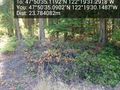
Expedition
Aerial image scouting (google and bing) didn't give me a lot of hope for this geohash point. The actual location seems to be close to the side of a building (google) and in heavy trees on a hillside (both).
Reaching the block, I saw this was indeed the case. While there was a car parked nearby, it didn't look as though anyone was home, so I snapped a few pictures of the area and posted a sign near some mailboxes. With luck, the homeowner scoped the spot out themselves (buried treasure?).
Based on the site survey, I'm not sure this point would be accessible without a machete even with permission of the homeowner...
Tracklog
Photos
Wicked foliage @47.8431,-122.3250


