Difference between revisions of "2015-07-14 52 1"
From Geohashing
imported>Sourcerer m ([live] Arrived.) |
imported>Sourcerer m ([live picture] Proof. [http://www.openstreetmap.org/?lat=52.74802208&lon=1.31572008&zoom=16&layers=B000FTF @52.7480,1.3157]) |
||
| Line 26: | Line 26: | ||
<gallery perrow="5"> | <gallery perrow="5"> | ||
| + | |||
| + | Image:2015-07-14_52_1_Sourcerer_1436829205331.jpg | Proof. [http://www.openstreetmap.org/?lat=52.74802208&lon=1.31572008&zoom=16&layers=B000FTF @52.7480,1.3157] | ||
</gallery> | </gallery> | ||
Revision as of 23:15, 13 July 2015
| Tue 14 Jul 2015 in 52,1: 52.7479969, 1.3157699 geohashing.info google osm bing/os kml crox |
Location
In a field south east of Buxton, Norfolk, UK.
Participants
Plans
Expedition two of two spanning midnight - 2015-07-13 52 1 - 2015-07-14 52 1 - ETA 00:00.
Expedition
- Arrived. -- Sourcerer (talk) @52.7480,1.3157 00:14, 14 July 2015 (GMT+01:00)
Photos
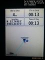
Proof. @52.7480,1.3157

Achievements
Sourcerer earned the OpenStreetMap achievement
|

Sourcerer issued a challenge for the Tale of Two Hashes achievement
Expeditions and Plans
| 2015-07-14 | ||
|---|---|---|
| Atlanta, Georgia | NWoodruff | In the parking lot of a shopping mall in Chamblee |
| Seattle, Washington | Thomcat | A forested lot near Meadowdale (or is it Beverly Acres?) in Lynnwood. |
| Norwich, United Kingdom | Sourcerer | In a field south east of Buxton, Norfolk, UK. |
Sourcerer's Expedition Links
2015-07-13 52 1 - 2015-07-14 52 1 - 2015-07-15 52 1 - KML file download of Sourcerer's expeditions for use with Google Earth.