Difference between revisions of "2015-07-20 52 0"
From Geohashing
imported>Sourcerer m ([live picture] Proof. [http://www.openstreetmap.org/?lat=52.40227461&lon=.99212229&zoom=16&layers=B000FTF @52.4023,.9921]) |
imported>FippeBot m (Location) |
||
| (4 intermediate revisions by one other user not shown) | |||
| Line 3: | Line 3: | ||
| lon=0 | | lon=0 | ||
| date=2015-07-20 | | date=2015-07-20 | ||
| + | | graticule_name=Cambridge, UK | ||
| + | | graticule_link=Cambridge, United Kingdom | ||
}} | }} | ||
__NOTOC__ | __NOTOC__ | ||
| Line 19: | Line 21: | ||
== Expedition == | == Expedition == | ||
| + | *Arrived. -- [[User:Sourcerer|Sourcerer]] ([[User talk:Sourcerer|talk]]) [http://www.openstreetmap.org/?lat=52.40227461&lon=.99212766&zoom=16&layers=B000FTF @52.4023,.9921] 00:03, 20 July 2015 (GMT+01:00) | ||
| + | There was a place to park about 45 metres from the hashpoint. This was close to the fence between the farmyard and the garden of a house. There were nice water fountain sounds from the garden. There were no gates, fences, security lights or dogs so it was easy and no one got disturbed. I pushed a metre or two through nettles and into Cupressus × leylandii trees to minimise the distance. | ||
| − | |||
| − | |||
== Photos == | == Photos == | ||
| Line 28: | Line 30: | ||
Image:2015-07-20_52_0_Sourcerer_1437346933642.jpg | Proof. [http://www.openstreetmap.org/?lat=52.40227461&lon=.99212229&zoom=16&layers=B000FTF @52.4023,.9921] | Image:2015-07-20_52_0_Sourcerer_1437346933642.jpg | Proof. [http://www.openstreetmap.org/?lat=52.40227461&lon=.99212229&zoom=16&layers=B000FTF @52.4023,.9921] | ||
| + | Image:2015-07-20 52 0 Sourcerer.jpg | Track in Google Earth | ||
</gallery> | </gallery> | ||
== Achievements == | == Achievements == | ||
{{#vardefine:ribbonwidth|800px}} | {{#vardefine:ribbonwidth|800px}} | ||
| + | {{Midnight geohash | ||
| + | | latitude = 52 | ||
| + | | longitude = 0 | ||
| + | | date = 2015-07-20 | ||
| + | | name = Sourcerer | ||
| + | }} | ||
{{Sourcerer_links | {{Sourcerer_links | ||
| Line 40: | Line 49: | ||
}} | }} | ||
| − | |||
| − | |||
[[Category:Expeditions]] | [[Category:Expeditions]] | ||
[[Category:Expeditions with photos]] | [[Category:Expeditions with photos]] | ||
[[Category:Coordinates reached]] | [[Category:Coordinates reached]] | ||
| − | + | {{location|GB|ENG|NFK}} | |
Latest revision as of 04:24, 15 August 2019
| Mon 20 Jul 2015 in Cambridge, UK: 52.4023071, 0.9920930 geohashing.info google osm bing/os kml crox |
Location
A farmyard at North Lopham, Norfolk, UK, 500 metres from the east graticule border.
Participants
Plans
Expedition two of two spanning midnight - 2015-07-19 52 1 - 2015-07-20 52 0 - ETA 00:00.
Expedition
- Arrived. -- Sourcerer (talk) @52.4023,.9921 00:03, 20 July 2015 (GMT+01:00)
There was a place to park about 45 metres from the hashpoint. This was close to the fence between the farmyard and the garden of a house. There were nice water fountain sounds from the garden. There were no gates, fences, security lights or dogs so it was easy and no one got disturbed. I pushed a metre or two through nettles and into Cupressus × leylandii trees to minimise the distance.
Photos
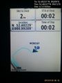
Proof. @52.4023,.9921
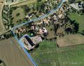
Track in Google Earth


Achievements
Sourcerer earned the Midnight Geohash achievement
|
Expeditions and Plans
| 2015-07-20 | ||
|---|---|---|
| Aurora, Illinois | Rookiek13, Kiamx | Next to a park in Bolingbrook, IL |
| Seattle, Washington | Thomcat | On the street in a new development (Glenshire at English Hill?) in North Re... |
| Cambridge, United Kingdom | Sourcerer | A farmyard at North Lopham, Norfolk, UK, 500 metres from the east graticule... |
| Koszalin, Poland | Klucken | A place between Łosino and Sierakowo Słupskie, villages in the administrati... |
Sourcerer's Expedition Links
2015-07-19 52 1 - 2015-07-20 52 0 - 2015-07-21 52 1 - KML file download of Sourcerer's expeditions for use with Google Earth.