Difference between revisions of "2015-08-01 52 9"
From Geohashing
imported>Fippe m |
m (Adding hours) |
||
| (4 intermediate revisions by 3 users not shown) | |||
| Line 26: | Line 26: | ||
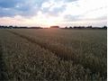
2015-08-01 52 09 04 Landscape.jpg | Same picture as the sunset, only focused differently. My phone camera is crazy. | 2015-08-01 52 09 04 Landscape.jpg | Same picture as the sunset, only focused differently. My phone camera is crazy. | ||
2015-08-01 52 09 05 Landscape.jpg | The view to the other side | 2015-08-01 52 09 05 Landscape.jpg | The view to the other side | ||
| − | |||
2015-08-01 52 09 07 Proof.png | Proof | 2015-08-01 52 09 07 Proof.png | Proof | ||
</gallery> | </gallery> | ||
==Achievements== | ==Achievements== | ||
| + | {{#vardefine:ribbonwidth|100%}} | ||
{{land geohash|latitude=52|longitude=9|date=2015-08-01|name=[[User:Fippe|Fippe]]|image=2015-08-01 52 09 01 Geohash.jpg}} | {{land geohash|latitude=52|longitude=9|date=2015-08-01|name=[[User:Fippe|Fippe]]|image=2015-08-01 52 09 01 Geohash.jpg}} | ||
| Line 37: | Line 37: | ||
[[Category:Coordinates reached]] | [[Category:Coordinates reached]] | ||
[[Category:Expeditions with photos]] | [[Category:Expeditions with photos]] | ||
| + | {{location|DE|NI|H}} | ||
| + | {{user categories|user=Fippe|bus=28|foot=4|hours=20}} | ||
Latest revision as of 19:03, 11 December 2022
| Sat 1 Aug 2015 in Hannover: 52.2679079, 9.7890831 geohashing.info google osm bing/os kml crox |
Location
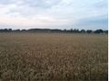
The Geohash is located on a field of wheat near Pattensen.
Participants
Plans
Take the bus to Pattensen, then walk.
Expedition
I took the bus 300 to Pattensen ZOB, but from there it was still a 2km to walk. I went barefoot, since it was a hot day (but I carried my shoes, just in case). As I arrived at the site, I saw that the geohash was located in a field of wheat. So I ran through about 30m field before arriving at the coordinates.
Photos
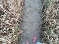
The Geohash
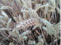
An ear of wheat
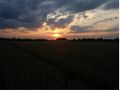
Landscape: Sunset
Same picture as the sunset, only focused differently. My phone camera is crazy.
The view to the other side
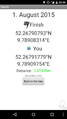
Proof


Achievements
Fippe earned the Land geohash achievement
|