Difference between revisions of "2015-08-02 48 13"
From Geohashing
imported>B2c (An expedition message sent via Geohash Droid for Android.) |
imported>FippeBot m (Location) |
||
| (11 intermediate revisions by 3 users not shown) | |||
| Line 20: | Line 20: | ||
== Location == | == Location == | ||
<!-- where you've surveyed the hash to be --> | <!-- where you've surveyed the hash to be --> | ||
| + | {{:User:B2c/Multi2015-08-02}} | ||
== Participants == | == Participants == | ||
| − | + | * [[User:Crankl|Crankl]] | |
| − | + | * [[User:B2c|B2c]] | |
| + | * [[User:Micsnare|Micsnare]] | ||
| − | == Plans == | + | == Plans / Expedition == |
| − | + | This is part of an elevenfold multihash. For the complete report of the multihash please head over [[2015-08-02_48_16|here]]. | |
| − | |||
| − | |||
| + | *Two down! -- [[User:B2c|B2c]] ([[User talk:B2c|talk]]) [http://www.openstreetmap.org/?lat=48.00326438&lon=13.70753353&zoom=16&layers=B000FTF @48.0033,13.7075] 02:41, 2 August 2015 (GMT+02:00) | ||
== Tracklog == | == Tracklog == | ||
<!-- if your GPS device keeps a log, you may post a link here --> | <!-- if your GPS device keeps a log, you may post a link here --> | ||
| Line 39: | Line 40: | ||
--> | --> | ||
<gallery perrow="5"> | <gallery perrow="5"> | ||
| + | |||
| + | Image:2015-08-02_48_13_B2c_1438475076113.jpg | [http://www.openstreetmap.org/?lat=48.00326951&lon=13.70753586&zoom=16&layers=B000FTF @48.0033,13.7075] | ||
| + | |||
| + | Image:2015-08-02_48_13_B2c_1438475096415.jpg | [http://www.openstreetmap.org/?lat=48.00327251&lon=13.70753736&zoom=16&layers=B000FTF @48.0033,13.7075] | ||
| + | |||
| + | Image:2015-08-02_48_13_micsnare_1438475144768.jpg | Drowned Rat meet Velociraptor.... | ||
</gallery> | </gallery> | ||
| Line 44: | Line 51: | ||
{{#vardefine:ribbonwidth|800px}} | {{#vardefine:ribbonwidth|800px}} | ||
<!-- Add any achievement ribbons you earned below, or remove this section --> | <!-- Add any achievement ribbons you earned below, or remove this section --> | ||
| + | |||
| + | [[Category:Expeditions]] | ||
| + | [[Category:Expeditions with photos]] | ||
| + | [[Category:Coordinates reached]] | ||
<!-- =============== USEFUL CATEGORIES FOLLOW ================ | <!-- =============== USEFUL CATEGORIES FOLLOW ================ | ||
Delete the next line ONLY if you have chosen the appropriate categories below. If you are unsure, don't worry. People will read your report and help you with the classification. --> | Delete the next line ONLY if you have chosen the appropriate categories below. If you are unsure, don't worry. People will read your report and help you with the classification. --> | ||
| − | |||
<!-- Potential categories. Please include all the ones appropriate to your expedition --> | <!-- Potential categories. Please include all the ones appropriate to your expedition --> | ||
| Line 84: | Line 94: | ||
(Don't forget to delete this final close comment marker) --> | (Don't forget to delete this final close comment marker) --> | ||
| + | {{location|AT|OÖ|VB}} | ||
Latest revision as of 00:50, 6 August 2019
| Sun 2 Aug 2015 in 48,13: 48.0012012, 13.7057050 geohashing.info google osm bing/os kml crox |
Location
All stops in consecutive order:
|
Participants
Plans / Expedition
This is part of an elevenfold multihash. For the complete report of the multihash please head over here.
- Two down! -- B2c (talk) @48.0033,13.7075 02:41, 2 August 2015 (GMT+02:00)
Tracklog
Photos
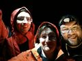
Drowned Rat meet Velociraptor....


