Difference between revisions of "2015-08-07 52 1"
imported>Sourcerer m ([live picture] Proof. [http://www.openstreetmap.org/?lat=52.52528071&lon=1.23768926&zoom=16&layers=B000FTF @52.5253,1.2377]) |
imported>Sourcerer m (→New expedition) |
||
| Line 19: | Line 19: | ||
== Expedition == | == Expedition == | ||
| + | |||
| + | === Attempt One === | ||
*As expected, not reachable. -- [[User:Sourcerer|Sourcerer]] ([[User talk:Sourcerer|talk]]) [http://www.openstreetmap.org/?lat=52.52528071&lon=1.23686850&zoom=16&layers=B000FTF @52.5253,1.2369] 23:35, 6 August 2015 (GMT+01:00) | *As expected, not reachable. -- [[User:Sourcerer|Sourcerer]] ([[User talk:Sourcerer|talk]]) [http://www.openstreetmap.org/?lat=52.52528071&lon=1.23686850&zoom=16&layers=B000FTF @52.5253,1.2369] 23:35, 6 August 2015 (GMT+01:00) | ||
| Line 28: | Line 30: | ||
I added the lakes to OpenStreetMap so at least the outing was not totally wasted. | I added the lakes to OpenStreetMap so at least the outing was not totally wasted. | ||
| + | === Attempt Two === | ||
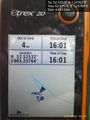
*Arrived. -- [[User:Sourcerer|Sourcerer]] ([[User talk:Sourcerer|talk]]) [http://www.openstreetmap.org/?lat=52.52527535&lon=1.23768926&zoom=16&layers=B000FTF @52.5253,1.2377] 16:01, 7 August 2015 (GMT+01:00) | *Arrived. -- [[User:Sourcerer|Sourcerer]] ([[User talk:Sourcerer|talk]]) [http://www.openstreetmap.org/?lat=52.52527535&lon=1.23768926&zoom=16&layers=B000FTF @52.5253,1.2377] 16:01, 7 August 2015 (GMT+01:00) | ||
| + | |||
| + | The midnight stealth approach is sometimes useful but not always. Today, a "bold as brass" drive onto the site worked better. I had spotted speed limit signs (5 mph). That seemed odd for private land so I Googled Taswood Lakes. It turned out to be a carp fishery with three lodges that holiday makers can hire and the fishermen can get day and season permits. So I arrived at the reception/shop and enquired about the lodges. I got a price list and a brochure and more importantly, permission to have a look around. Three minutes later I was close to the hashpoint. Under the trees, the satnav lock was a little unstable but my distance dropped to four metres. | ||
| + | |||
| + | And the electric fences were to keep otters out. Otter + Carp = Nom-nom! | ||
| + | |||
| + | And there was access via the cricket pitch but a night trespass would have been unsociable. | ||
| + | |||
== Photos == | == Photos == | ||
| Line 37: | Line 47: | ||
Image:2015-08-07 52 1 Sourcerer 2.jpg | Electric Fence in Four Languages. | Image:2015-08-07 52 1 Sourcerer 2.jpg | Electric Fence in Four Languages. | ||
Image:2015-08-07 52 1 Sourcerer 3.jpg | Barbed Wire on top of the gate. | Image:2015-08-07 52 1 Sourcerer 3.jpg | Barbed Wire on top of the gate. | ||
| − | |||
Image:2015-08-07_52_1_Sourcerer_1438959648075.jpg | Proof. [http://www.openstreetmap.org/?lat=52.52528071&lon=1.23768926&zoom=16&layers=B000FTF @52.5253,1.2377] | Image:2015-08-07_52_1_Sourcerer_1438959648075.jpg | Proof. [http://www.openstreetmap.org/?lat=52.52528071&lon=1.23768926&zoom=16&layers=B000FTF @52.5253,1.2377] | ||
| + | Image:800px-2015-08-07_52_1_Sourcerer_4.jpg | Ornamental Lakes | ||
| + | Image:800px-2015-08-07_52_1_Sourcerer_5.jpg | Near the Hashpoint | ||
| + | Image:800px-2015-08-07_52_1_Sourcerer_6.jpg | Otter Prevention | ||
| + | Image:800px-2015-08-07_52_1_Sourcerer_7.jpg | Electric Otter Fence | ||
| + | Image:800px-2015-08-07_52_1_Sourcerer_8.jpg | Cricket Pitch | ||
| + | Image:800px-2015-08-07_52_1_Sourcerer_9.jpg | More Lakes | ||
</gallery> | </gallery> | ||
| Line 68: | Line 83: | ||
[[Category:Expeditions]] | [[Category:Expeditions]] | ||
[[Category:Expeditions with photos]] | [[Category:Expeditions with photos]] | ||
| − | [[Category:Coordinates | + | [[Category:Coordinates reached]] |
Revision as of 16:35, 7 August 2015
| Fri 7 Aug 2015 in 52,1: 52.5252822, 1.2376178 geohashing.info google osm bing/os kml crox |
Location
In a lake! Lower Tasburgh, Norfolk, UK.
Participants
Plans
Expedition two of two spanning midnight - 2015-08-06 52 0 - 2015-08-07 52 1 - ETA 00:00? This does not look reachable but it's worth a try.
Expedition
Attempt One
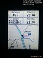
- As expected, not reachable. -- Sourcerer (talk) @52.5253,1.2369 23:35, 6 August 2015 (GMT+01:00)
I arrived a few minutes before midnight only to find almost military grade fences with an electrified wire running along the top. There was no way to sneak through this without doing damage, even if the electrics were not live. In any case the Google Earth view showed the hashpoint in a lake. After the initial failure I made a half hearted attempt to locate another approach from the north. There was access to a cricket pitch but this probably did not connect with the lakes. I could not find another route heading south. I abandoned the scene just after midnight to ensure it was not a failed retrohash.
August is proving to be a bad month for the Norwich graticule. We are a week into the month and have managed only one reachable hashpoint. Perhaps our luck will improve. Of course it could be much worse; at least I'm not based in Texel! 2015-08-03 52 1 was obviously in the garden of a private house. On the other fail-days, the hashpoints were in the north sea.
I added the lakes to OpenStreetMap so at least the outing was not totally wasted.
Attempt Two
- Arrived. -- Sourcerer (talk) @52.5253,1.2377 16:01, 7 August 2015 (GMT+01:00)
The midnight stealth approach is sometimes useful but not always. Today, a "bold as brass" drive onto the site worked better. I had spotted speed limit signs (5 mph). That seemed odd for private land so I Googled Taswood Lakes. It turned out to be a carp fishery with three lodges that holiday makers can hire and the fishermen can get day and season permits. So I arrived at the reception/shop and enquired about the lodges. I got a price list and a brochure and more importantly, permission to have a look around. Three minutes later I was close to the hashpoint. Under the trees, the satnav lock was a little unstable but my distance dropped to four metres.
And the electric fences were to keep otters out. Otter + Carp = Nom-nom!
And there was access via the cricket pitch but a night trespass would have been unsociable.
Photos
Closest approach. @52.5253,1.2369
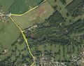
Track in Google Earth
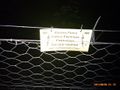
Electric Fence in Four Languages.
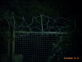
Barbed Wire on top of the gate.
Proof. @52.5253,1.2377
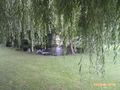
Ornamental Lakes
Near the Hashpoint

Otter Prevention
Electric Otter Fence
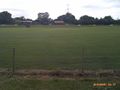
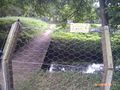
Cricket Pitch
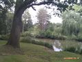
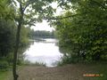
More Lakes


Achievements
Sourcerer earned the No trespassing consolation prize
|
Sourcerer earned the OpenStreetMap achievement
|
Expeditions and Plans
| 2015-08-07 | ||
|---|---|---|
| Buffalo, New York | Pedalpusher | Shoulder of Jamison Rd in front of Moog |
| Erfurt, Germany | Reinhard | On the road between Lippelsdorf and Schmiedefeld, Thuringia, Germany. |
| Norwich, United Kingdom | Sourcerer | In a lake! Lower Tasburgh, Norfolk, UK. |
Sourcerer's Expedition Links
2015-08-06 52 0 - 2015-08-07 52 1 - 2015-08-08 51 1 - KML file download of Sourcerer's expeditions for use with Google Earth.