Difference between revisions of "2015-08-21 52 0"
From Geohashing
imported>Sourcerer m ([live picture] Proof. [http://www.openstreetmap.org/?lat=52.94148445&lon=.83711743&zoom=16&layers=B000FTF @52.9415,.8371]) |
imported>Sourcerer m (→New expedition) |
||
| Line 20: | Line 20: | ||
== Expedition == | == Expedition == | ||
| + | *Arrived. -- [[User:Sourcerer|Sourcerer]] ([[User talk:Sourcerer|talk]]) [http://www.openstreetmap.org/?lat=52.94148445&lon=.83711743&zoom=16&layers=B000FTF @52.9415,.8371] 22:12, 21 August 2015 (GMT+01:00) | ||
| + | This went to plan. Google Street View showed an ideal parking place and field access. The hypotenuse was 330 metres and the field perimeter followed the other two sides of the triangle. It was harvested wheat or barley. | ||
| − | |||
| − | |||
== Photos == | == Photos == | ||
<gallery perrow="5"> | <gallery perrow="5"> | ||
| − | |||
Image:2015-08-21_52_0_Sourcerer_1440191525982.jpg | Proof. [http://www.openstreetmap.org/?lat=52.94148445&lon=.83711743&zoom=16&layers=B000FTF @52.9415,.8371] | Image:2015-08-21_52_0_Sourcerer_1440191525982.jpg | Proof. [http://www.openstreetmap.org/?lat=52.94148445&lon=.83711743&zoom=16&layers=B000FTF @52.9415,.8371] | ||
| + | Image:2015-08-21_52_0_Sourcerer.jpg | Track in Google Earth | ||
</gallery> | </gallery> | ||
| Line 40: | Line 40: | ||
| name = Sourcerer | | name = Sourcerer | ||
| place = Golden Gate/s | | place = Golden Gate/s | ||
| + | }} | ||
| + | {{Multihash2 | ||
| + | | date = 2015-08-21 | ||
| + | | name = Sourcerer | ||
| + | | count = 2 | ||
}} | }} | ||
| Line 49: | Line 54: | ||
}} | }} | ||
| − | |||
| − | |||
| − | |||
[[Category:Expeditions]] | [[Category:Expeditions]] | ||
[[Category:Expeditions with photos]] | [[Category:Expeditions with photos]] | ||
[[Category:Coordinates reached]] | [[Category:Coordinates reached]] | ||
| − | |||
Revision as of 23:58, 21 August 2015
| Fri 21 Aug 2015 in 52,0: 52.9415095, 0.8371010 geohashing.info google osm bing/os kml crox |
Location
A field perimeter hashpoint north of Golden Gates, Holkham Hall, Norfolk, UK.
Participants
Plans
Expedition one of two spanning midnight - 2015-08-21 52 0 - 2015-08-22 52 1 - ETA 22:20
Expedition
- Arrived. -- Sourcerer (talk) @52.9415,.8371 22:12, 21 August 2015 (GMT+01:00)
This went to plan. Google Street View showed an ideal parking place and field access. The hypotenuse was 330 metres and the field perimeter followed the other two sides of the triangle. It was harvested wheat or barley.
Photos
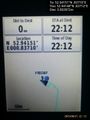
Proof. @52.9415,.8371
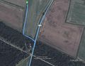
Track in Google Earth


Achievements

Sourcerer issued a challenge for the Tale of Two Hashes achievement
by geohashing in a place named Golden Gate/s from the (52, 0) geohash on 2015-08-21.
Sourcerer earned the Multihash Achievement
|
Expeditions and Plans
| 2015-08-21 | ||
|---|---|---|
| London East, United Kingdom | Sourcerer | 1) In a harvested field between Fordham and Little Horkesley, Essex, UK. |
| Cambridge, United Kingdom | Sourcerer | 2) A field perimeter hashpoint north of Golden Gates, Holkham Hall, Norfolk... |
Sourcerer's Expedition Links
2015-08-21 51 0 - 2015-08-21 52 0 - 2015-08-22 52 1 - KML file download of Sourcerer's expeditions for use with Google Earth.