Difference between revisions of "2015-08-25 52 0"
imported>Sourcerer m ([live picture] Proof [http://www.openstreetmap.org/?lat=52.26740777&lon=.61398983&zoom=16&layers=B000FTF @52.2674,.6140]) |
imported>FippeBot m (Location) |
||
| (10 intermediate revisions by one other user not shown) | |||
| Line 3: | Line 3: | ||
| lon=0 | | lon=0 | ||
| date=2015-08-25 | | date=2015-08-25 | ||
| + | | graticule_name=Cambridge, UK | ||
| + | | graticule_link=Cambridge, United Kingdom | ||
}} | }} | ||
__NOTOC__ | __NOTOC__ | ||
| − | |||
== Location == | == Location == | ||
| − | In a field, a few yards off a public footpath, north of the A14 and west of Bury Saint Edmunds, Suffolk UK. | + | 2) In a field, a few yards off a public footpath, north of the A14 and west of Bury Saint Edmunds, Suffolk UK. |
== Participants == | == Participants == | ||
| − | [[User:Sourcerer|Sourcerer]] | + | * [[User:Sourcerer|Sourcerer]] |
| + | * [[User:Sourcerer|Sourcerer]] again as a retrohash on 2015-12-15 just before midnight. | ||
== Plans == | == Plans == | ||
Expedition two of three spanning midnight - [[2015-08-25 52 1]] - [[2015-08-25 52 0]] - [[2015-08-26 52 0]] - ETA 23:00. | Expedition two of three spanning midnight - [[2015-08-25 52 1]] - [[2015-08-25 52 0]] - [[2015-08-26 52 0]] - ETA 23:00. | ||
| + | |||
| + | Expedition two of three spanning midnight - [[2015-12-15 52 0]] - [[2015-08-25 52 0|2015-08-25 52 0 Retro]] - [[2015-12-16 52 0]] - ETA 23:50 on 2015-12-15. | ||
== Expedition == | == Expedition == | ||
| + | *Arrived. -- [[User:Sourcerer|Sourcerer]] ([[User talk:Sourcerer|talk]]) [http://www.openstreetmap.org/?lat=52.26740777&lon=.61398983&zoom=16&layers=B000FTF @52.2674,.6140] 22:58, 25 August 2015 (GMT+01:00) | ||
| + | This was easy enough. A short walk on a pubic footpath and an even shorter walk across wheat or barley stubble to the hashpoint. | ||
| + | === Retro on 2015-12-15 === | ||
| − | *Arrived. -- [[User:Sourcerer|Sourcerer]] ([[User talk:Sourcerer|talk]]) [http://www.openstreetmap.org/?lat=52. | + | *Arrived. -- [[User:Sourcerer|Sourcerer]] ([[User talk:Sourcerer|talk]]) [http://www.openstreetmap.org/?lat=52.26741314&lon=.61400056&zoom=16&layers=B000FTF @52.2674,.6140] 23:51, 15 December 2015 (GMT) |
| − | |||
| − | + | This was 220 metres from [[2015-12-16 52 0]] and so easily reached it just had to be done. | |
| + | == Photos == | ||
| + | <gallery perrow="2"> | ||
Image:2015-08-25_52_0_Sourcerer_1440539801665.jpg | Proof [http://www.openstreetmap.org/?lat=52.26740777&lon=.61398983&zoom=16&layers=B000FTF @52.2674,.6140] | Image:2015-08-25_52_0_Sourcerer_1440539801665.jpg | Proof [http://www.openstreetmap.org/?lat=52.26740777&lon=.61398983&zoom=16&layers=B000FTF @52.2674,.6140] | ||
| + | Image:2015-08-25 52 0 Sourcerer.jpg | Track in Google Earth | ||
| + | Image:2015-08-25_52_0_Sourcerer_1450223453688.jpg | Retro proof. [http://www.openstreetmap.org/?lat=52.26741314&lon=.61400056&zoom=16&layers=B000FTF @52.2674,.6140] | ||
| + | Image:2015-12-16_52_0_Sourcerer.jpg | Google Earth Retro Track | ||
</gallery> | </gallery> | ||
== Achievements == | == Achievements == | ||
{{#vardefine:ribbonwidth|700px}} | {{#vardefine:ribbonwidth|700px}} | ||
| − | + | {{Multihash2 | |
| + | | date = 2015-08-25 | ||
| + | | count = 2 | ||
| + | | name = Sourcerer | ||
| + | }} | ||
{{Sourcerer_links | {{Sourcerer_links | ||
| Line 43: | Line 58: | ||
}} | }} | ||
| − | |||
| − | |||
[[Category:Expeditions]] | [[Category:Expeditions]] | ||
[[Category:Expeditions with photos]] | [[Category:Expeditions with photos]] | ||
[[Category:Coordinates reached]] | [[Category:Coordinates reached]] | ||
| − | + | [[Category:Retro meetup]] | |
| + | [[Category:Retro coordinates reached]] | ||
| + | {{location|GB|ENG|SFK}} | ||
Latest revision as of 04:56, 15 August 2019
| Tue 25 Aug 2015 in Cambridge, UK: 52.2674124, 0.6139990 geohashing.info google osm bing/os kml crox |
Location
2) In a field, a few yards off a public footpath, north of the A14 and west of Bury Saint Edmunds, Suffolk UK.
Participants
Plans
Expedition two of three spanning midnight - 2015-08-25 52 1 - 2015-08-25 52 0 - 2015-08-26 52 0 - ETA 23:00.
Expedition two of three spanning midnight - 2015-12-15 52 0 - 2015-08-25 52 0 Retro - 2015-12-16 52 0 - ETA 23:50 on 2015-12-15.
Expedition
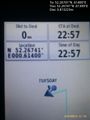
- Arrived. -- Sourcerer (talk) @52.2674,.6140 22:58, 25 August 2015 (GMT+01:00)
This was easy enough. A short walk on a pubic footpath and an even shorter walk across wheat or barley stubble to the hashpoint.
Retro on 2015-12-15
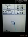
- Arrived. -- Sourcerer (talk) @52.2674,.6140 23:51, 15 December 2015 (GMT)
This was 220 metres from 2015-12-16 52 0 and so easily reached it just had to be done.
Photos
Proof @52.2674,.6140
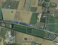
Track in Google Earth
Retro proof. @52.2674,.6140
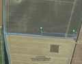
Google Earth Retro Track


Achievements
Sourcerer earned the Multihash Achievement
|
Expeditions and Plans
| 2015-08-25 | ||
|---|---|---|
| Buffalo, New York | Pedalpusher | In a field next to an abandoned farm house on New Oregon Rd |
| Portland, Oregon | Jim | In a field above Hwy 26 north of Beaverton |
| Mannheim, Germany | DODO | Next to a roundabout in Rot. |
| Kassel, Germany | GeorgDerReisende | At the side of a meadow south of Niederkaufungen. |
| Cambridge, United Kingdom | Sourcerer | 2) In a field, a few yards off a public footpath, north of the A14 and west... |
| Norwich, United Kingdom | Sourcerer | 1) In a field between Westleton and Dunwich Heaths close to the Minsmere bi... |
| Helsinki, Finland | Someone went | Somewhere |
Sourcerer's Expedition Links
2015-08-25 52 1 - 2015-08-25 52 0 - 2015-08-26 52 0 - KML file download of Sourcerer's expeditions for use with Google Earth.