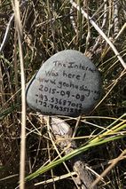
2015-09-08 -43 172

| Tue 8 Sep 2015 in -43,172: -43.5368701, 172.7435190 geohashing.info google osm bing/os kml crox |
Location
Location Option 1: South Brighton, Christchurch, New Zealand

Location Option 2: Pegasus Bay, Pacific Ocean, New Zealand
Location Option 3: Kirwee, Canterbury, New Zealand


Participants
The Quaternary (talk) family geohashers
Plans
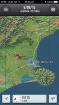
I check my preferred geohash coordinate calculator (Eupeodes at http://geohashing.info), and it looked like a perfect hash - right on the beach where I should really spend more time. So off my trusty companion and I went to check it out.
Expedition
However, when I got there I checked out the peeron coordinate calculator (for some random reason which escapes me, but I wish I never had!), and it had the geohash out in the middle of the ocean - in Pegasus Bay. Curious.
Looking at my iPhone app "Geohash+" it had the geohash in a completely different spot altogether - about 30 kilometres inland. Curiouser and curiouser.
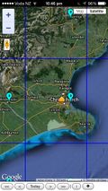
So I checked out the "Geohasing.org Expedition Archive page for 2015-09-08" at http://wiki.xkcd.com/geohashing/2015-09-08 - surely this is the 'truth' - and it agreed with the Geohash+ app (and also the map to the right of this text).
The poster tool (http://geo.crox.net/poster/2015-09-08_-43_172), however, agreed with Eupeodes.
What is going on?
Local time (NZST) today is Tuesday, September 8, 2015. Being East of 30W, we need the opening Dow Jones Industrial Average of Monday, September 7, 2015 (Eastern). However, this is a "Dow Holiday" so the opening price needed is that on Friday, September 4, 2015.
Looking on Google (and carabiner.peeron.com and geo.crox.net), the opening price of DJIA on 2015-09-04 is quoted as: 16,371.76
Looking on finance.yahoo.com, the opening price of DJIA on 2015-09-04 is quoted as: 16,341.16
Could this discrepancy be the source of the problem?
Looking at the debugging information of http://carabiner.peeron.com/xkcd/map/map.html?date=2015-09-08&lat=-43&long=172&zoom=8, it was clear what was wrong in this particular case; the debugging information showed that it hadn't picked up an opening DJIA at all. So that explained that one.
The poster tool used 16,371.76 (agreeing with google, but not yahoo), and was giving the sea-side location as per Eupeodes.
I'm not sure what the Geohasing.org Expedition Archive page / Geohash+ app was using as the DJIA opening price, as they don't specify it. But whatever it was, it must be the same thing.
So, I'd welcome any input here, as I'm not sure that reaching the geohash as per Eupeodes and the Poster Tool is correct, or whether I should be going with the Geohasing.org Expedition Archive page and the Geohash+ app.
If the former, this is a successful expedition; if the latter, then this is an unsuccessful expedition.
Photos
The geohash at "Option 1"
At the hash
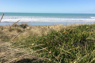
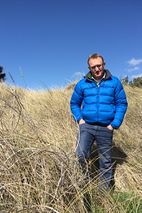
View over the ridge, about 5 metres from the hash

