Difference between revisions of "2015-09-22 52 5"
From Geohashing
imported>JwB m (→Photos) |
imported>FippeBot m (Location) |
||
| (One intermediate revision by one other user not shown) | |||
| Line 45: | Line 45: | ||
</gallery> | </gallery> | ||
| − | |||
| − | |||
| − | |||
| − | |||
| − | |||
| − | |||
| − | |||
| − | |||
| − | |||
| − | |||
| − | |||
| − | |||
| − | |||
| − | |||
| − | |||
[[Category:Expeditions]] | [[Category:Expeditions]] | ||
| − | |||
[[Category:Expeditions with photos]] | [[Category:Expeditions with photos]] | ||
| − | |||
| − | |||
| − | |||
| − | |||
| − | |||
[[Category:Coordinates reached]] | [[Category:Coordinates reached]] | ||
| − | + | {{location|NL|GE}} | |
| − | |||
| − | |||
| − | |||
| − | |||
| − | |||
| − | |||
| − | |||
| − | |||
| − | |||
| − | |||
| − | |||
| − | |||
| − | |||
| − | |||
| − | |||
| − | |||
| − | |||
Latest revision as of 05:13, 15 August 2019
| Tue 22 Sep 2015 in 52,5: 52.3146090, 5.7726424 geohashing.info google osm bing/os kml crox |
Location
On the Elspeetsche Heide
Participants
Plans
Expedition
First dropped my 12 yr old daugther and 3 of her friends off at the school camp for her new high-school. Then it was some 15 kms from there, so I drove up to the parking spot close to the hash, and from there walked into the natural park that contains today's 52 5 hash. Nice stroll, birds of prey screaming in the forest. Mushrooms (cantharell, cep!) that on this beautiful day after the rains grow like ... well mushrooms. Harvest a little, and let the rest grow. Then across the moor, up to the hash. Easy to get spot on. Return.
Tracklog
Photos
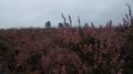
hash in the direction of the trees
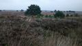
looking back from the hash

here we are


