Difference between revisions of "2015-09-25 46 -122"
From Geohashing
imported>Michael5000 (→Location) |
imported>FippeBot m (Location) |
||
| (2 intermediate revisions by 2 users not shown) | |||
| Line 1: | Line 1: | ||
| − | |||
| − | [[ | + | [[File:2015-09-25 46 -122 church.JPG|thumb|left]] |
| − | |||
| − | |||
| − | |||
| − | |||
{{meetup graticule | {{meetup graticule | ||
| lat=46 | | lat=46 | ||
| Line 23: | Line 18: | ||
== Participants == | == Participants == | ||
| − | |||
| − | |||
| − | + | * [[user:michael5000|Michael5000]] | |
| − | |||
== Expedition == | == Expedition == | ||
| − | |||
| − | + | Late September is the time of year at my work where, if you don't use your vacation time, you lose it, so what better way to while away an autumn day than the great sport of geohashing. I drove north through steady rains into the state of Washington, took the Castle Rock exit, and ducked into the parking lot of "The Rock Church." That sounds like a classic rock radio station to me, but of course it's a house of worship, so this one was a holy hash. I took a few pictures, then headed to a local wifi connection point to file this report. | |
| − | |||
== Photos == | == Photos == | ||
| − | |||
| − | |||
| − | |||
<gallery perrow="5"> | <gallery perrow="5"> | ||
| + | File:2015-09-25 46 -122 church.JPG | The Rock Church! | ||
| + | File:2015-09-25 46 -122 gadget.JPG | Yes, I reached the hashpoint. | ||
| + | File:2015-09-25 46 -122 selfie.JPG | Here I am. | ||
| + | File:2015-09-25 46 -122 vehicle.JPG | The new expedition vehicle. | ||
| + | File:2015-09-25 46 -122 bear.JPG | Naturally the hashscot was along for the ride. | ||
</gallery> | </gallery> | ||
== Achievements == | == Achievements == | ||
{{#vardefine:ribbonwidth|800px}} | {{#vardefine:ribbonwidth|800px}} | ||
| − | |||
| − | + | {{holy hash | |
| − | |||
| − | |||
| − | + | | latitude = 46 | |
| − | + | | longitude = -122 | |
| − | [[ | + | | date = 2015-09-25 |
| − | -- | + | | name = [[user:michael5000|Michael5000]] |
| + | | description = The Rock Church | ||
| + | | image = 2015-09-25 46 -122 church.JPG | ||
| − | + | }} | |
| − | |||
[[Category:Expeditions]] | [[Category:Expeditions]] | ||
| − | |||
[[Category:Expeditions with photos]] | [[Category:Expeditions with photos]] | ||
| − | |||
| − | |||
| − | |||
| − | |||
| − | |||
[[Category:Coordinates reached]] | [[Category:Coordinates reached]] | ||
| − | + | {{location|US|WA|CW}} | |
| − | |||
| − | |||
| − | |||
| − | |||
| − | |||
| − | |||
| − | |||
| − | |||
| − | |||
| − | |||
| − | |||
| − | |||
| − | |||
| − | |||
| − | |||
| − | |||
| − | |||
Latest revision as of 01:19, 7 August 2019

| Fri 25 Sep 2015 in 46,-122: 46.2603419, -122.8930985 geohashing.info google osm bing/os kml crox |
Location
On the lot of "The Rock Church" in Castle Rock.
Participants
Expedition
Late September is the time of year at my work where, if you don't use your vacation time, you lose it, so what better way to while away an autumn day than the great sport of geohashing. I drove north through steady rains into the state of Washington, took the Castle Rock exit, and ducked into the parking lot of "The Rock Church." That sounds like a classic rock radio station to me, but of course it's a house of worship, so this one was a holy hash. I took a few pictures, then headed to a local wifi connection point to file this report.
Photos
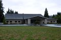
The Rock Church!
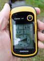
Yes, I reached the hashpoint.

Here I am.
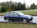
The new expedition vehicle.
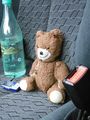
Naturally the hashscot was along for the ride.


Achievements
Michael5000 earned the Holy hash achievement
|