Difference between revisions of "2015-09-26 52 4"
From Geohashing
imported>JwB m (→Participants) |
imported>FippeBot m (Location) |
||
| (5 intermediate revisions by 2 users not shown) | |||
| Line 20: | Line 20: | ||
== Location == | == Location == | ||
<!-- where you've surveyed the hash to be --> | <!-- where you've surveyed the hash to be --> | ||
| + | Farmland near Harmelen | ||
== Participants == | == Participants == | ||
| Line 28: | Line 29: | ||
== Expedition == | == Expedition == | ||
| − | + | 3.7 km as the crow flies, 6km as the bike rides. Beautiful early fall wheather. Quick ride up there, 250 m walk through the grass, & a nice ride back home. | |
== Tracklog == | == Tracklog == | ||
| Line 35: | Line 36: | ||
== Photos == | == Photos == | ||
<!-- Insert pictures between the gallery tags using the following format: | <!-- Insert pictures between the gallery tags using the following format: | ||
| − | |||
--> | --> | ||
<gallery perrow="5"> | <gallery perrow="5"> | ||
| + | Image:view524.jpg | looking towards | ||
| + | Image:proof524.png | there | ||
| + | Image:hash524.jpg | down there | ||
</gallery> | </gallery> | ||
== Achievements == | == Achievements == | ||
{{#vardefine:ribbonwidth|800px}} | {{#vardefine:ribbonwidth|800px}} | ||
| − | |||
| − | + | {{bicycle geohash | |
| − | + | | latitude = 52 | |
| − | + | | longitude = 4 | |
| + | | date = 2015-09-26 | ||
| + | | name = JwB | ||
| + | | distance = 12 km | ||
| + | | bothways = true | ||
| + | }} | ||
| − | |||
| − | |||
| − | |||
| − | |||
| − | |||
| − | |||
| − | |||
| − | |||
[[Category:Expeditions]] | [[Category:Expeditions]] | ||
| − | |||
[[Category:Expeditions with photos]] | [[Category:Expeditions with photos]] | ||
| − | |||
| − | |||
| − | |||
| − | |||
| − | |||
[[Category:Coordinates reached]] | [[Category:Coordinates reached]] | ||
| − | + | {{location|NL|UT}} | |
| − | |||
| − | |||
| − | |||
| − | |||
| − | |||
| − | |||
| − | |||
| − | |||
| − | |||
| − | |||
| − | |||
| − | |||
| − | |||
| − | |||
| − | |||
| − | |||
| − | |||
Latest revision as of 05:16, 15 August 2019
| Sat 26 Sep 2015 in 52,4: 52.0737960, 4.9585734 geohashing.info google osm bing/os kml crox |
Location
Farmland near Harmelen
Participants
Plans
Expedition
3.7 km as the crow flies, 6km as the bike rides. Beautiful early fall wheather. Quick ride up there, 250 m walk through the grass, & a nice ride back home.
Tracklog
Photos
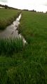
looking towards
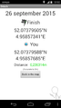
there
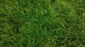
down there


Achievements
JwB earned the Bicycle geohash achievement
|