Difference between revisions of "2015-10-04 -13 131"
imported>Felix Dance (Created page) |
m (Location correction) |
||
| (4 intermediate revisions by 2 users not shown) | |||
| Line 14: | Line 14: | ||
== Expedition == | == Expedition == | ||
| + | I was at work on the Saturday morning when I noticed this hash. I've been in Darwin for two years now, and every day I've checked the coordinates for an accessible hash in the remote Batchelor graticule, and especially since the three other Darwin-area graticules had been opened up. So it looked like this was the day. | ||
| + | |||
| + | Getting up after a bit of a messy night in town, I contacted Alex and we both drove out along the Stuart Highway with our bikes. The drive took about an hour and a half, and we stopped on the side of the road, down the embankment, to ride out the approximately 3kms to where the hash was. I was on my road bike and was quite surprised the dry terrain allowed me to ride relatively unimpeded. | ||
| + | |||
| + | On the way, we encountered kangaroos, a herd of buffalo (luckily running away from us), and even a bizarre willy willy - a miniature tornado that rolled across the landscape just in front of us, opaque with black dust. | ||
| + | |||
| + | With a bit of dancing around we at last reached the coordinates. The hash seemed to be in an old, dry swamp. Taking a few photos, we rode back to the car and drove to Adelaide River on the way back to Darwin. Here we had a pub lunch and beers, and decided to use the rest of the afternoon riding out to Robin Falls along a narrow sealed track about 15kms away. We had a brief swim, rode back, and headed home, just in time for Alex to get to beach volleyball. | ||
We rode 6.6kms and reached the hash at 11:45am. | We rode 6.6kms and reached the hash at 11:45am. | ||
| Line 24: | Line 31: | ||
Image:Geohash 2015 10 04 -13 131 Bikes.JPG|Bikes collected at the hash | Image:Geohash 2015 10 04 -13 131 Bikes.JPG|Bikes collected at the hash | ||
Image:Geohash 2015 10 04 -13 131 Hashshot.JPG|Felix and Alex at the hash | Image:Geohash 2015 10 04 -13 131 Hashshot.JPG|Felix and Alex at the hash | ||
| + | Image:Geohash 2015 10 04 -13 131 Proof.JPG|GPS Phone app proof | ||
Image:Geohash 2015 10 04 -13 131 Beer.JPG|Adelaide River celebratory beer | Image:Geohash 2015 10 04 -13 131 Beer.JPG|Adelaide River celebratory beer | ||
Image:Geohash 2015 10 04 -13 131 Ride.JPG|Alex riding to Robyn Falls | Image:Geohash 2015 10 04 -13 131 Ride.JPG|Alex riding to Robyn Falls | ||
| Line 31: | Line 39: | ||
[[Category:Expeditions with photos]] | [[Category:Expeditions with photos]] | ||
[[Category:Coordinates reached]] | [[Category:Coordinates reached]] | ||
| + | {{location|AU|NT|TE}} | ||
Latest revision as of 14:32, 4 October 2020
| Sun 4 Oct 2015 in -13,131: -13.4769097, 131.3807025 geohashing.info google osm bing/os kml crox |
Location
In the bush near Hayes Creek, just off the Stuart Highway.
Participants
- Felix Dance
- Alex
Expedition
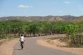
I was at work on the Saturday morning when I noticed this hash. I've been in Darwin for two years now, and every day I've checked the coordinates for an accessible hash in the remote Batchelor graticule, and especially since the three other Darwin-area graticules had been opened up. So it looked like this was the day.
Getting up after a bit of a messy night in town, I contacted Alex and we both drove out along the Stuart Highway with our bikes. The drive took about an hour and a half, and we stopped on the side of the road, down the embankment, to ride out the approximately 3kms to where the hash was. I was on my road bike and was quite surprised the dry terrain allowed me to ride relatively unimpeded.
On the way, we encountered kangaroos, a herd of buffalo (luckily running away from us), and even a bizarre willy willy - a miniature tornado that rolled across the landscape just in front of us, opaque with black dust.
With a bit of dancing around we at last reached the coordinates. The hash seemed to be in an old, dry swamp. Taking a few photos, we rode back to the car and drove to Adelaide River on the way back to Darwin. Here we had a pub lunch and beers, and decided to use the rest of the afternoon riding out to Robin Falls along a narrow sealed track about 15kms away. We had a brief swim, rode back, and headed home, just in time for Alex to get to beach volleyball.
We rode 6.6kms and reached the hash at 11:45am.
Here is the route of our trip.
Photos
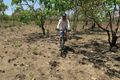
Alex riding to the hash
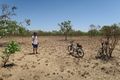
Bikes collected at the hash
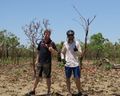
Felix and Alex at the hash
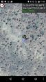
GPS Phone app proof

Adelaide River celebratory beer
Alex riding to Robyn Falls


