Difference between revisions of "2015-10-04 52 1"
From Geohashing
imported>Sourcerer m (→Achievements) |
imported>FippeBot m (Location) |
||
| (6 intermediate revisions by one other user not shown) | |||
| Line 3: | Line 3: | ||
| lon=1 | | lon=1 | ||
| date=2015-10-04 | | date=2015-10-04 | ||
| + | | graticule_name=Norwich, UK | ||
| + | | graticule_link=Norwich, United Kingdom | ||
}} | }} | ||
__NOTOC__ | __NOTOC__ | ||
| Line 8: | Line 10: | ||
== Location == | == Location == | ||
| − | In a field close to home, east of Cobblers's Green, Norfolk, UK. | + | In a field close to home, east of Cobblers's Green, Norfolk, UK. [http://w3w.co/alternate.flown.survivor alternate.flown.survivor] |
== Participants == | == Participants == | ||
| Line 16: | Line 18: | ||
== Plans == | == Plans == | ||
| − | + | Go there sometime. There are no nearby reachable points to pair this with. | |
== Expedition == | == Expedition == | ||
| + | *Arrived. -- [[User:Sourcerer|Sourcerer]] ([[User talk:Sourcerer|talk]]) [http://www.openstreetmap.org/?lat=52.47690976&lon=1.38071001&zoom=16&layers=B000FTF @52.4769,1.3807] 21:44, 4 October 2015 (GMT+01:00) | ||
| + | The point was 1.1 km from the nearest road. It was a dark night but the public footpaths were easy enough to follow with an LED torch. The last bit was across a cultivated field with no sign of new growth yet. | ||
== Photos == | == Photos == | ||
<gallery> | <gallery> | ||
| − | + | Image:2015-10-04_52_1_Sourcerer_1443991429959.jpg | Proof. [http://www.openstreetmap.org/?lat=52.47690976&lon=1.38071537&zoom=16&layers=B000FTF @52.4769,1.3807] | |
| + | Image:2015-10-04 52 1 Sourcerer.jpg | Track in Google Earth | ||
</gallery> | </gallery> | ||
| Line 30: | Line 35: | ||
{{#vardefine:ribbonwidth|700px}} | {{#vardefine:ribbonwidth|700px}} | ||
| + | {{OpenStreetMap achievement | ||
| + | | latitude = 52 | ||
| + | | longitude = 1 | ||
| + | | date = 2015-10-04 | ||
| + | | OSMlink = 34433759 | ||
| + | | name = Sourcerer | ||
| + | }} | ||
{{Sourcerer_links | {{Sourcerer_links | ||
| Line 38: | Line 50: | ||
}} | }} | ||
| − | |||
| − | |||
[[Category:Expeditions]] | [[Category:Expeditions]] | ||
[[Category:Expeditions with photos]] | [[Category:Expeditions with photos]] | ||
[[Category:Coordinates reached]] | [[Category:Coordinates reached]] | ||
| − | + | {{location|GB|ENG|NFK}} | |
Latest revision as of 05:22, 15 August 2019
| Sun 4 Oct 2015 in Norwich, UK: 52.4769097, 1.3807025 geohashing.info google osm bing/os kml crox |
Location
In a field close to home, east of Cobblers's Green, Norfolk, UK. alternate.flown.survivor
Participants
Plans
Go there sometime. There are no nearby reachable points to pair this with.
Expedition
- Arrived. -- Sourcerer (talk) @52.4769,1.3807 21:44, 4 October 2015 (GMT+01:00)
The point was 1.1 km from the nearest road. It was a dark night but the public footpaths were easy enough to follow with an LED torch. The last bit was across a cultivated field with no sign of new growth yet.
Photos
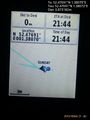
Proof. @52.4769,1.3807
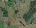
Track in Google Earth


Achievements
Sourcerer earned the OpenStreetMap achievement
|
Expeditions and Plans
| 2015-10-04 | ||
|---|---|---|
| Batchelor, Australia | Felix Dance, Alex | In the bush near Hayes Creek, just off the Stuart Highway. |
| Orlando, Florida | Geoff, Erica | On the road of a suburb next to Lake Mary Jess. Continue down from Bimini a... |
| Daytona Beach, Florida | Geoff, Erica | Just off Highway 100. Looks like it's not on property, so we can walk out a... |
| Mannheim, Germany | DODO | On a corn field near Ludwigshafen-Oggersheim. |
| Norwich, United Kingdom | Sourcerer | In a field close to home, east of Cobblers's Green, Norfolk, UK. alternate.flown.survivor... |
Sourcerer's Expedition Links
2015-09-30 52 1 - 2015-10-04 52 1 - 2015-10-06 52 1 - KML file download of Sourcerer's expeditions for use with Google Earth.