Difference between revisions of "2015-10-07 52 1"
From Geohashing
imported>Sourcerer m (→Location) |
imported>Sourcerer m (→Achievements) |
||
| Line 38: | Line 38: | ||
| date = 2015-10-07 | | date = 2015-10-07 | ||
| name = Sourcerer | | name = Sourcerer | ||
| + | }} | ||
| + | {{Last man standing | ||
| + | | latitude = 52 | ||
| + | | longitude = 1 | ||
| + | | date = 2015-10-07 | ||
| + | | name = Sourcerer | ||
| + | | gender = Man | ||
}} | }} | ||
Revision as of 17:20, 15 October 2015
| Wed 7 Oct 2015 in 52,1: 52.4590315, 1.2218887 geohashing.info google osm bing/os kml crox |
Location
In a field off the A140 south of Long Stratton, Norfolk, UK. ramp.sensible.kickbacks
Participants
Plans
Expedition two of two spanning midnight - 2015-10-06 52 1 - 2015-10-07 52 1 - ETA 00:00.
Expedition
- Arrived. -- Sourcerer (talk) @52.4590,1.2219 00:00, 7 October 2015 (GMT+01:00)
This was as easy as the previous outing was difficult. There was a convenient field entrance to park. A short walk on mown tracks led to the stubble field perimeter hashpoint. Shortly after getting back to the car, the predicted rain arrived in torrents but I was warm and dry.
Photos
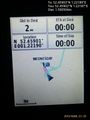
Proof @52.4590,1.2219
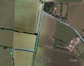
Track in Google Earth


Achievements
Sourcerer earned the Midnight Geohash achievement
|
Sourcerer earned the Last Man standing achievement
|
Expeditions and Plans
| 2015-10-07 | ||
|---|---|---|
| Norwich, United Kingdom | Sourcerer | In a field off the A140 south of Long Stratton, Norfolk, UK. ramp.sensible.kickbacks... |
Sourcerer's Expedition Links
2015-10-06 52 1 - 2015-10-07 52 1 - 2015-10-08 52 1 - KML file download of Sourcerer's expeditions for use with Google Earth.