Difference between revisions of "2015-10-08 52 1"
From Geohashing
imported>Sourcerer m ([live picture] Proof. [http://www.openstreetmap.org/?lat=52.63798714&lon=1.06197774&zoom=16&layers=B000FTF @52.6380,1.0620]) |
imported>Sourcerer m (→New Expedition) |
||
| Line 20: | Line 20: | ||
== Expedition == | == Expedition == | ||
| + | *Arrived. -- [[User:Sourcerer|Sourcerer]] ([[User talk:Sourcerer|talk]]) [http://www.openstreetmap.org/?lat=52.63798714&lon=1.06197774&zoom=16&layers=B000FTF @52.6380,1.0620] 22:16, 8 October 2015 (GMT+01:00) | ||
| + | The location was on very high ground (for Norfolk) and there were views towards Tacolneston and Mendlesham. Both TV transmitter masts were clearly visible. There was a gravel farm access road all the way. The last 10 metres were in wet grass next to a huge wood pile. There was enough wood to keep a house heated for years. Perhaps Prangle's Wood is now somewhat smaller. | ||
| − | |||
| − | |||
== Photos == | == Photos == | ||
<gallery> | <gallery> | ||
| − | |||
Image:2015-10-08_52_1_Sourcerer_1444338898759.jpg | Proof. [http://www.openstreetmap.org/?lat=52.63798714&lon=1.06197774&zoom=16&layers=B000FTF @52.6380,1.0620] | Image:2015-10-08_52_1_Sourcerer_1444338898759.jpg | Proof. [http://www.openstreetmap.org/?lat=52.63798714&lon=1.06197774&zoom=16&layers=B000FTF @52.6380,1.0620] | ||
| + | Image:2015-10-08_52_1_Sourcerer.jpg | Track in Google Earth | ||
</gallery> | </gallery> | ||
| Line 40: | Line 40: | ||
}} | }} | ||
| − | |||
| − | |||
| − | |||
[[Category:Expeditions]] | [[Category:Expeditions]] | ||
[[Category:Expeditions with photos]] | [[Category:Expeditions with photos]] | ||
[[Category:Coordinates reached]] | [[Category:Coordinates reached]] | ||
| − | |||
Revision as of 00:38, 9 October 2015
| Thu 8 Oct 2015 in 52,1: 52.6379896, 1.0620073 geohashing.info google osm bing/os kml crox |
Location
Prangle's Wood, north of Brandon Parva, Norfolk, UK.
Participants
Plans
Expedition one of two spanning midnight - 2015-10-08 52 1 - 2015-10-09 52 1 - ETA 22:20.
Expedition
- Arrived. -- Sourcerer (talk) @52.6380,1.0620 22:16, 8 October 2015 (GMT+01:00)
The location was on very high ground (for Norfolk) and there were views towards Tacolneston and Mendlesham. Both TV transmitter masts were clearly visible. There was a gravel farm access road all the way. The last 10 metres were in wet grass next to a huge wood pile. There was enough wood to keep a house heated for years. Perhaps Prangle's Wood is now somewhat smaller.
Photos
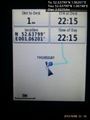
Proof. @52.6380,1.0620
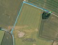
Track in Google Earth


Achievements
Expeditions and Plans
| 2015-10-08 | ||
|---|---|---|
| Norwich, United Kingdom | Sourcerer | Prangle's Wood, north of Brandon Parva, Norfolk, UK. fired.noodle.mainframe... |
| Bielefeld, Germany | Fippe | located in a forest near Grönloh. |
| Bremen, Germany | Fippe | located in a glade near Hooksiel. |
Sourcerer's Expedition Links
2015-10-07 52 1 - 2015-10-08 52 1 - 2015-10-09 52 1 - KML file download of Sourcerer's expeditions for use with Google Earth.