Difference between revisions of "2015-10-17 49 5"
From Geohashing
imported>JwB m (→Plans) |
m (per Renaming Proposal) |
||
| (5 intermediate revisions by 3 users not shown) | |||
| Line 32: | Line 32: | ||
== Expedition == | == Expedition == | ||
| − | + | As we got closer, it got foggier but no problem in identifying the exit and the roundabout. Driving as close as possible to the guardrail to ensure we would be bnear the hash. My wife driving and me trying to take a screenshot of the hashdroid app. Too late with clicking, only when reading agin up to 24m I got a shot. Still we went through the hash as evidenced in google maps. | |
== Tracklog == | == Tracklog == | ||
| Line 38: | Line 38: | ||
== Photos == | == Photos == | ||
| − | + | ||
| − | |||
| − | |||
<gallery perrow="5"> | <gallery perrow="5"> | ||
| + | Image:495appr.jpg | on our way | ||
| + | Image:495 exit.jpg | exit here | ||
| + | Image:GPSe-151017-093627.jpg | and get back to the motorway | ||
| + | Image:495Track.JPG | track from GPS | ||
</gallery> | </gallery> | ||
== Achievements == | == Achievements == | ||
{{#vardefine:ribbonwidth|800px}} | {{#vardefine:ribbonwidth|800px}} | ||
| − | + | {{Border geohash achievement | |
| + | |||
| + | | latitude = 49 | ||
| + | | longitude = 5 | ||
| + | | date = 2015-10-17 | ||
| + | | country1 = Netherlands | ||
| + | | country2 = Belgium | ||
| + | | name = JwB | ||
| + | |||
| + | }} | ||
| + | {{Graticule unlocked | ||
| − | + | | latitude = 49 | |
| − | + | | longitude = 5 | |
| − | + | | date = 2015-10-17 | |
| + | | name = JwB | ||
| + | | image = 495 exit.jpg | ||
| − | + | }} | |
| − | |||
| − | |||
| − | |||
| − | |||
| − | |||
[[Category:Expeditions]] | [[Category:Expeditions]] | ||
| − | |||
[[Category:Expeditions with photos]] | [[Category:Expeditions with photos]] | ||
| − | |||
| − | |||
| − | |||
| − | |||
| − | |||
[[Category:Coordinates reached]] | [[Category:Coordinates reached]] | ||
| − | + | {{location|BE|WLX}} | |
| − | |||
| − | |||
| − | |||
| − | |||
| − | |||
| − | |||
| − | |||
| − | |||
| − | |||
| − | |||
| − | |||
| − | |||
| − | |||
| − | |||
| − | |||
| − | |||
| − | |||
Latest revision as of 05:02, 20 March 2024
| Sat 17 Oct 2015 in 49,5: 49.8748105, 5.4796840 geohashing.info google osm bing/os kml crox |
Location
Entrance #27 of the A4 (E411) motorway
Participants
Plans
as we were driving by anyway, we could just exit the motorway at #27, take the roundabout and enter again. by driving all the way to the right the hash would be in the pocket
Expedition
As we got closer, it got foggier but no problem in identifying the exit and the roundabout. Driving as close as possible to the guardrail to ensure we would be bnear the hash. My wife driving and me trying to take a screenshot of the hashdroid app. Too late with clicking, only when reading agin up to 24m I got a shot. Still we went through the hash as evidenced in google maps.
Tracklog
Photos
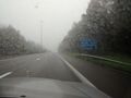
on our way
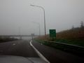
exit here
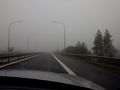
and get back to the motorway
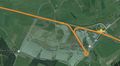
track from GPS


Achievements
JwB earned the Border geohash achievement
|
JwB earned the Graticule Unlocked Achievement
|