2015-11-06 52 1
| Fri 6 Nov 2015 in Norwich, UK: 52.1034130, 1.4701148 geohashing.info google osm bing/os kml crox |
Location
In a field, off a public footpath and the Suffolk, Coastal Path, west of the Butley River, Suffolk, UK.
Participants
Plans
Go there on Friday evening.
Expedition
- Arrived. -- Sourcerer (talk) @52.1034,1.4701 20:30, 6 November 2015 (GMT)
There was space at the road-side to park. A farm track/public footpath led in the right direction. There were a few minutes of uncertainty when signs were spotted - "Infection Control", "Pig Farming" and "Keep Out". The final field had been planted with winter wheat and tractor tracks led to the hashpoint. After a wet day, the ground was wet but fairly clean. It was very sandy soil. The rain had stopped and stars were shining. It was oddly mild for November.
Photos
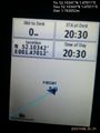
Proof. @52.1034,1.4701
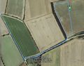
Track in Google Earth


Achievements
Sourcerer earned the OpenStreetMap achievement
|
Expeditions and Plans
| 2015-11-06 | ||
|---|---|---|
| Grand Rapids, Michigan | Mcbaneg | A driveway on 40th Street, Grandville, MI |
| Mannheim, Germany | Someone went | In Friedrichstal, a little bit more than 10 km north of Karlsruhe, not far ... |
| Norwich, United Kingdom | Sourcerer | In a field, off a public footpath and the Suffolk, Coastal Path, west of th... |
Sourcerer's Expedition Links
2015-11-05 52 1 - 2015-11-06 52 1 - 2015-11-07 52 1 - KML file download of Sourcerer's expeditions for use with Google Earth.