Difference between revisions of "2015-11-08 52 -2"
imported>Tongs |
imported>FippeBot m (Location) |
||
| (9 intermediate revisions by 2 users not shown) | |||
| Line 1: | Line 1: | ||
| − | |||
| − | |||
| − | |||
| − | |||
| − | |||
| − | |||
| − | |||
| − | |||
| − | |||
| − | |||
{{meetup graticule | {{meetup graticule | ||
| lat=52 | | lat=52 | ||
| lon=-2 | | lon=-2 | ||
| date=2015-11-08 | | date=2015-11-08 | ||
| + | | graticule_name=Shrewsbury, UK | ||
| + | | graticule_link=Shrewsbury, United Kingdom | ||
}} | }} | ||
| − | |||
| − | |||
__NOTOC__ | __NOTOC__ | ||
| − | |||
== Location == | == Location == | ||
In a small field adjacent to Trent Road, Stone. | In a small field adjacent to Trent Road, Stone. | ||
| − | |||
| − | |||
== Participants == | == Participants == | ||
| Line 34: | Line 21: | ||
I'm not sure if this is public land, or someone's garden, or what, but got some help from PaintedJaguar: | I'm not sure if this is public land, or someone's garden, or what, but got some help from PaintedJaguar: | ||
| − | :''If you switch to Google satellite view and zoom in, it looks to me like there is a reasonably well-used path running along the north-eastern edge of the field, behind the gardens of the houses on Newcastle Road. OpenStreetMap also suggests a footpath there. Based on that, I'd be willing to take a guess that the hashpoint is in a field, rather than a garden, and is reachable from the path. On the other hand, I've been bitten before (in a non-geohasing sense) by a path shown on OpenStreetMap that turend out to be blocked by a barbed wire fence ;-) [[User:PaintedJaguar|PaintedJaguar]] ([[User talk:PaintedJaguar|talk]]) 21:30, 6 November 2015 (EST)'' | + | :''It's hard to make out from Google Maps Street View whether this is someone's back garden or not. I think it probably is, so I'm not sure this is going to work. Can any more experienced geohashers determine whether [http://maps.google.com/maps?q=52.905347,-2.158697 this] is a field or a garden? [[User:Tongs|Tongs]] ([[User talk:Tongs|talk]]) 12:39, 6 November 2015 (EST)'' |
| + | ::''If you switch to Google satellite view and zoom in, it looks to me like there is a reasonably well-used path running along the north-eastern edge of the field, behind the gardens of the houses on Newcastle Road. OpenStreetMap also suggests a footpath there. Based on that, I'd be willing to take a guess that the hashpoint is in a field, rather than a garden, and is reachable from the path. On the other hand, I've been bitten before (in a non-geohasing sense) by a path shown on OpenStreetMap that turend out to be blocked by a barbed wire fence ;-) [[User:PaintedJaguar|PaintedJaguar]] ([[User talk:PaintedJaguar|talk]]) 21:30, 6 November 2015 (EST)'' | ||
| + | :::It's worth a look. New houses were being built in 2009 (Hartley Close). You might find an accessible building site in this field. PaintedJaguar's path is real. StreetView shows the safety barriers to stop cyclists. I have some out-of-date local knowledge. If you walk south east along the canal tow path, at the third or fourth bridge you will reach the Star, a Marston's pub that used to be excellent and perhaps still is. You can watch the narrow boats locking up or down while supping your pint. Of course they have a car park if you are driving. --[[User:Sourcerer|Sourcerer]] ([[User talk:Sourcerer|talk]]) 09:49, 7 November 2015 (EST) | ||
| + | ::::Thanks for all the useful information! I'll report back tomorrow! [[User:Tongs|Tongs]] ([[User talk:Tongs|talk]]) 14:12, 7 November 2015 (EST) | ||
| − | + | == Expedition == | |
| − | + | I was passing through Stone railway station on my way back from attending the excellent and highly-recommeded [http://www.mathsjam.com/conference/ MathsJam conference]. Since the hashpoint was only about 800m from the station, I thought it would be simple to go for a quick walk to the hashpoint and come back, with enough time to take the next train to the south. The railway line separated me from the hashpoint, so the slightly-longer-than 800m walk took me over a bridge and past a small lock. Soon I noticed Trent Road and after a short walk down it saw that, contrary to my fears, PaintedJaguar and Sourcerer were quite right. Access was trivial and I wandered over autumn leaves into a small field, finding the hashpoint in seconds, at 14:18. I didn’t stick around - (52,-2) seems much less active than (52,0). | |
| − | + | ||
| + | After the usual photography, I retraced my steps and joined a set of mathematicians disjoint to the set of those that I’d got a lift with an hour earlier. I made my way down to to Coventry to visit some friends. | ||
| − | + | I was very fortunate that the hashpoint fell so close to the station. Now I have visited points in three graticules. | |
| − | |||
== Photos == | == Photos == | ||
| − | + | ||
| − | |||
| − | |||
<gallery perrow="5"> | <gallery perrow="5"> | ||
| + | Image:2015-11-08_52_-2_gps.jpg | My GPS receiver reports that I am 0m away, and without much pacing around to get there. | ||
| + | Image:2015-11-08_52_-2_lock.jpg | A lock that I passed on the way. | ||
| + | Image:2015-11-08_52_-2_way_in.jpg | This autumnal scene demonstrates that access was easy, perhaps even inviting. | ||
| + | Image:2015-11-08_52_-2_panorama.jpg | A breathtaking panorama. | ||
</gallery> | </gallery> | ||
== Achievements == | == Achievements == | ||
{{#vardefine:ribbonwidth|800px}} | {{#vardefine:ribbonwidth|800px}} | ||
| − | |||
| − | |||
| − | |||
| − | |||
| − | |||
| − | |||
| − | |||
| − | |||
| − | |||
| − | |||
| − | |||
| − | |||
| − | |||
| − | |||
[[Category:Expeditions]] | [[Category:Expeditions]] | ||
| − | |||
[[Category:Expeditions with photos]] | [[Category:Expeditions with photos]] | ||
| − | |||
| − | |||
| − | |||
| − | |||
| − | |||
[[Category:Coordinates reached]] | [[Category:Coordinates reached]] | ||
| − | + | {{location|GB|ENG|STS}} | |
| − | |||
| − | |||
| − | |||
| − | |||
| − | |||
| − | |||
| − | |||
| − | |||
| − | |||
| − | |||
| − | |||
| − | |||
| − | |||
| − | |||
| − | |||
| − | |||
| − | |||
Latest revision as of 05:45, 15 August 2019
| Sun 8 Nov 2015 in Shrewsbury, UK: 52.9053471, -2.1586973 geohashing.info google osm bing/os kml crox |
Location
In a small field adjacent to Trent Road, Stone.
Participants
Plans
I will be passing through Stone at about 2pm-3pm on Sunday, so I'll take a few hundred metres' detour and see if I can get to the hashpoint. Looking at the inactivity of this graticule, I'm not expecting any meetups, but if someone wants to, please leave a message and I'll be more exact about the time.
I'm not sure if this is public land, or someone's garden, or what, but got some help from PaintedJaguar:
- It's hard to make out from Google Maps Street View whether this is someone's back garden or not. I think it probably is, so I'm not sure this is going to work. Can any more experienced geohashers determine whether this is a field or a garden? Tongs (talk) 12:39, 6 November 2015 (EST)
- If you switch to Google satellite view and zoom in, it looks to me like there is a reasonably well-used path running along the north-eastern edge of the field, behind the gardens of the houses on Newcastle Road. OpenStreetMap also suggests a footpath there. Based on that, I'd be willing to take a guess that the hashpoint is in a field, rather than a garden, and is reachable from the path. On the other hand, I've been bitten before (in a non-geohasing sense) by a path shown on OpenStreetMap that turend out to be blocked by a barbed wire fence ;-) PaintedJaguar (talk) 21:30, 6 November 2015 (EST)
- It's worth a look. New houses were being built in 2009 (Hartley Close). You might find an accessible building site in this field. PaintedJaguar's path is real. StreetView shows the safety barriers to stop cyclists. I have some out-of-date local knowledge. If you walk south east along the canal tow path, at the third or fourth bridge you will reach the Star, a Marston's pub that used to be excellent and perhaps still is. You can watch the narrow boats locking up or down while supping your pint. Of course they have a car park if you are driving. --Sourcerer (talk) 09:49, 7 November 2015 (EST)
- If you switch to Google satellite view and zoom in, it looks to me like there is a reasonably well-used path running along the north-eastern edge of the field, behind the gardens of the houses on Newcastle Road. OpenStreetMap also suggests a footpath there. Based on that, I'd be willing to take a guess that the hashpoint is in a field, rather than a garden, and is reachable from the path. On the other hand, I've been bitten before (in a non-geohasing sense) by a path shown on OpenStreetMap that turend out to be blocked by a barbed wire fence ;-) PaintedJaguar (talk) 21:30, 6 November 2015 (EST)
Expedition
I was passing through Stone railway station on my way back from attending the excellent and highly-recommeded MathsJam conference. Since the hashpoint was only about 800m from the station, I thought it would be simple to go for a quick walk to the hashpoint and come back, with enough time to take the next train to the south. The railway line separated me from the hashpoint, so the slightly-longer-than 800m walk took me over a bridge and past a small lock. Soon I noticed Trent Road and after a short walk down it saw that, contrary to my fears, PaintedJaguar and Sourcerer were quite right. Access was trivial and I wandered over autumn leaves into a small field, finding the hashpoint in seconds, at 14:18. I didn’t stick around - (52,-2) seems much less active than (52,0).
After the usual photography, I retraced my steps and joined a set of mathematicians disjoint to the set of those that I’d got a lift with an hour earlier. I made my way down to to Coventry to visit some friends.
I was very fortunate that the hashpoint fell so close to the station. Now I have visited points in three graticules.
Photos
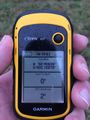
My GPS receiver reports that I am 0m away, and without much pacing around to get there.
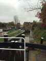
A lock that I passed on the way.
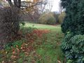
This autumnal scene demonstrates that access was easy, perhaps even inviting.
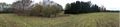
A breathtaking panorama.


