Difference between revisions of "2015-11-23 52 0"
From Geohashing
imported>Sourcerer m ([live picture] Proof. [http://www.openstreetmap.org/?lat=52.14715898&lon=.67329347&zoom=16&layers=B000FTF @52.1472,.6733]) |
imported>Sourcerer m (→New expedition) |
||
| Line 20: | Line 20: | ||
== Expedition == | == Expedition == | ||
| + | *Arrived. -- [[User:Sourcerer|Sourcerer]] ([[User talk:Sourcerer|talk]]) [http://www.openstreetmap.org/?lat=52.14714289&lon=.67339003&zoom=16&layers=B000FTF @52.1471,.6734] 22:47, 23 November 2015 (GMT) | ||
| + | There was nowhere safe to park on the main road. The hashpoint lane looked like a good place to turn round and the distance dropped to two or three metres while doing this. Most convenient and easy! | ||
| − | |||
| − | |||
== Photos == | == Photos == | ||
<gallery> | <gallery> | ||
| − | |||
Image:2015-11-23_52_0_Sourcerer_1448318786818.jpg | Proof. [http://www.openstreetmap.org/?lat=52.14715898&lon=.67329347&zoom=16&layers=B000FTF @52.1472,.6733] | Image:2015-11-23_52_0_Sourcerer_1448318786818.jpg | Proof. [http://www.openstreetmap.org/?lat=52.14715898&lon=.67329347&zoom=16&layers=B000FTF @52.1472,.6733] | ||
| + | Image:2015-11-23_52_0_Sourcerer.jpg | Google Earth Track | ||
</gallery> | </gallery> | ||
| Line 40: | Line 40: | ||
}} | }} | ||
| − | |||
| − | |||
[[Category:Expeditions]] | [[Category:Expeditions]] | ||
[[Category:Expeditions with photos]] | [[Category:Expeditions with photos]] | ||
[[Category:Coordinates reached]] | [[Category:Coordinates reached]] | ||
| − | |||
Revision as of 01:03, 24 November 2015
| Mon 23 Nov 2015 in 52,0: 52.1471419, 0.6734756 geohashing.info google osm bing/os kml crox |
Location
A gravel lane off the B1066 between Brockley and Hartest, Suffolk, UK.
Participants
Plans
Expedition one of two spanning midnight - 2015-11-23 52 0 - 2015-11-24 52 0 - ETA 23:00.
Expedition
- Arrived. -- Sourcerer (talk) @52.1471,.6734 22:47, 23 November 2015 (GMT)
There was nowhere safe to park on the main road. The hashpoint lane looked like a good place to turn round and the distance dropped to two or three metres while doing this. Most convenient and easy!
Photos
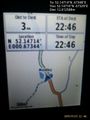
Proof. @52.1472,.6733
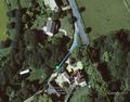
Google Earth Track


Achievements
Expeditions and Plans
| 2015-11-23 | ||
|---|---|---|
| Cambridge, United Kingdom | Sourcerer | A gravel lane off the B1066 between Brockley and Hartest, Suffolk, UK. |
Sourcerer's Expedition Links
2015-11-22 52 1 - 2015-11-23 52 0 - 2015-11-24 52 0 - KML file download of Sourcerer's expeditions for use with Google Earth.