Difference between revisions of "2015-11-27 52 0"
imported>Sourcerer (→Planning) |
imported>FippeBot m (Location) |
||
| (5 intermediate revisions by one other user not shown) | |||
| Line 3: | Line 3: | ||
| lon=0 | | lon=0 | ||
| date=2015-11-27 | | date=2015-11-27 | ||
| + | | graticule_name=Cambridge, UK | ||
| + | | graticule_link=Cambridge, United Kingdom | ||
}} | }} | ||
__NOTOC__ | __NOTOC__ | ||
| Line 16: | Line 18: | ||
== Plans == | == Plans == | ||
| − | + | Expedition one of two spanning midnight - [[2015-11-27 52 0]] - [[2015-11-28 52 1]] - ETA 22:50. | |
== Expedition == | == Expedition == | ||
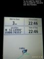
| + | *Arrived. -- [[User:Sourcerer|Sourcerer]] ([[User talk:Sourcerer|talk]]) [http://www.openstreetmap.org/?lat=52.14897215&lon=.78352153&zoom=16&layers=B000FTF @52.1490,.7835] 22:45, 27 November 2015 (GMT) | ||
| + | It was very windy and wet. There were mini-floods and fallen branches. I had to reverse out of the first lane because there was no parking place. The second was OK. A short walk back to the grassy, un-gated meadow was routine apart from the umbrella trying to escape. About 30 metres from the road, I was able to upload an "Arrived" message but the image upload failed. It succeeded later when I was approaching [[2015-11-28 52 1]] if anyone ever checks the coordinates that carefully. | ||
| + | |||
| + | There were some over the top Christmas decorations covering an entire house close to my parking place. | ||
== Photos == | == Photos == | ||
<gallery> | <gallery> | ||
| + | Image:2015-11-27_52_0_Sourcerer_1448664411677.jpg | Proof. [http://www.openstreetmap.org/?lat=52.54805267&lon=1.06128573&zoom=16&layers=B000FTF @52.5481,1.0613] | ||
| + | Image:2015-11-27_52_0_Sourcerer.jpg | Google Earth Track | ||
| + | Image:2015-11-27_52_0_Sourcerer_Lights.jpg | Wind blown camera shake Christmas lights. | ||
</gallery> | </gallery> | ||
| Line 36: | Line 45: | ||
}} | }} | ||
| − | |||
| − | |||
[[Category:Expeditions]] | [[Category:Expeditions]] | ||
[[Category:Expeditions with photos]] | [[Category:Expeditions with photos]] | ||
[[Category:Coordinates reached]] | [[Category:Coordinates reached]] | ||
| − | + | {{location|GB|ENG|SFK}} | |
Latest revision as of 05:58, 15 August 2019
| Fri 27 Nov 2015 in Cambridge, UK: 52.1489697, 0.7835055 geohashing.info google osm bing/os kml crox |
Location
In a field close to the A1141 between Cockfield and Button's Green, Suffolk, UK.
Participants
Plans
Expedition one of two spanning midnight - 2015-11-27 52 0 - 2015-11-28 52 1 - ETA 22:50.
Expedition
- Arrived. -- Sourcerer (talk) @52.1490,.7835 22:45, 27 November 2015 (GMT)
It was very windy and wet. There were mini-floods and fallen branches. I had to reverse out of the first lane because there was no parking place. The second was OK. A short walk back to the grassy, un-gated meadow was routine apart from the umbrella trying to escape. About 30 metres from the road, I was able to upload an "Arrived" message but the image upload failed. It succeeded later when I was approaching 2015-11-28 52 1 if anyone ever checks the coordinates that carefully.
There were some over the top Christmas decorations covering an entire house close to my parking place.
Photos
Proof. @52.5481,1.0613
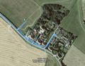
Google Earth Track

Wind blown camera shake Christmas lights.


Achievements
Expeditions and Plans
| 2015-11-27 | ||
|---|---|---|
| Tamworth, Australia | redbeard | Somewhere |
| Praha, Czech Republic | Someone went | between Čelákovice and Mochov, Czech Republic |
| Leipzig, Germany | TheOneRing | on a field at Zschetzsch near Grimma. |
| Cambridge, United Kingdom | Sourcerer | In a field close to the A1141 between Cockfield and Button's Green, Suffolk... |
Sourcerer's Expedition Links
2015-11-26 52 1 - 2015-11-27 52 0 - 2015-11-28 52 1 - KML file download of Sourcerer's expeditions for use with Google Earth.