Difference between revisions of "2015-12-02 49 8"
imported>DODO (→Photos) |
m (Location correction) |
||
| (4 intermediate revisions by 2 users not shown) | |||
| Line 39: | Line 39: | ||
== Tracklog == | == Tracklog == | ||
<!-- if your GPS device keeps a log, you may post a link here --> | <!-- if your GPS device keeps a log, you may post a link here --> | ||
| − | + | [[https://www.komoot.de/tour/7464787 5KM bullriding]] and two more to get back on my way to the office. | |
== Photos == | == Photos == | ||
| Line 45: | Line 45: | ||
Image:2012-##-## ## ## Alpha.jpg | Witty Comment | Image:2012-##-## ## ## Alpha.jpg | Witty Comment | ||
--> | --> | ||
| − | + | It was just around sunset so some pictures are blurred. | |
| − | <gallery perrow=" | + | <gallery perrow="4"> |
| + | Image: 2015-12-02_49_8-1.jpg|proof of transport | ||
| + | Image: 2015-12-02_49_8-2.jpg|first view to the hash, reed in the foreground | ||
| + | Image: 2015-12-02_49_8-3.jpg|second view to the hash, now easy to reach | ||
| + | Image: 2015-12-02_49_8-4.jpg|proof (missed the 0) | ||
| + | Image: 2015-12-02_49_8-5.jpg|view to the east | ||
| + | Image: 2015-12-02_49_8-7.jpg|view to the north | ||
| + | Image: 2015-12-02_49_8-6.jpg|view to the hasher | ||
</gallery> | </gallery> | ||
| Line 52: | Line 59: | ||
{{#vardefine:ribbonwidth|800px}} | {{#vardefine:ribbonwidth|800px}} | ||
<!-- Add any achievement ribbons you earned below, or remove this section --> | <!-- Add any achievement ribbons you earned below, or remove this section --> | ||
| + | {{land geohash | ||
| + | | latitude = 49 | ||
| + | | longitude = 8 | ||
| + | | date = 2015-12-02 | ||
| + | | name = DODO | ||
| + | }} | ||
| − | + | [[Category:Expeditions]] | |
| − | |||
| − | [[Category: | ||
| − | + | [[Category:Expeditions with photos]] | |
| − | |||
| − | |||
| − | |||
| − | |||
| − | |||
| − | |||
| − | |||
| − | |||
| − | |||
| − | |||
| − | |||
| − | |||
| − | |||
| − | |||
[[Category:Coordinates reached]] | [[Category:Coordinates reached]] | ||
| − | + | {{location|DE|RP|RP}} | |
| − | |||
| − | |||
| − | |||
| − | |||
| − | |||
| − | |||
| − | |||
| − | |||
| − | |||
| − | |||
| − | |||
| − | |||
| − | |||
| − | |||
| − | |||
| − | |||
| − | |||
Latest revision as of 20:30, 16 May 2020
| Wed 2 Dec 2015 in 49,8: 49.2883594, 8.4236225 geohashing.info google osm bing/os kml crox |
Location
In the nature protection area Flötzgrün, an island in the Bergheimer Altrhein.
Participants
Plans
Just to close not to go. Went there on my way to the office this morning but if anyone else will come, I could return and have a meetup at 17:15 or later.
Expedition
Went there with my bull on my way to the office. It was very easy to get up to 50 m to the hash, but as always, the last 50m is what counts. The direct way to the hash was blocked with man high reed, interspersed with thorny blackberries and some waterholes. Behind the reed I could see a dry area with some trees and some grass so I tried to cross the reed part, but after 5 m I gave up and decided to try another route. I continued the way I came and found a path in the direction of the hash.
And just when I needed it there was another footpath that led me to the dry area. From here on it was just a simple 30 m walk and I even reached a zero with hardly any dancing. I took some pictures and continued my way to work.
Tracklog
[5KM bullriding] and two more to get back on my way to the office.
Photos
It was just around sunset so some pictures are blurred.
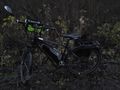
proof of transport
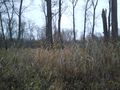
first view to the hash, reed in the foreground
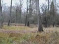
second view to the hash, now easy to reach

proof (missed the 0)
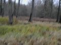
view to the east
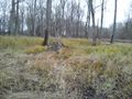
view to the north
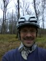
view to the hasher


Achievements
DODO earned the Land geohash achievement
|