Difference between revisions of "2015-12-06 52 1"
From Geohashing
imported>Sourcerer m ([live picture] Proof. [http://www.openstreetmap.org/?lat=52.43390322&lon=1.43785715&zoom=16&layers=B000FTF @52.4339,1.4379]) |
imported>Sourcerer m (→Achievements) |
||
| Line 47: | Line 47: | ||
| next = 2015-12-07 52 0 | | next = 2015-12-07 52 0 | ||
| date = 2015-12-06 | | date = 2015-12-06 | ||
| − | |||
| − | |||
| − | |||
[[Category:Expeditions]] | [[Category:Expeditions]] | ||
[[Category:Expeditions with photos]] | [[Category:Expeditions with photos]] | ||
[[Category:Coordinates reached]] | [[Category:Coordinates reached]] | ||
| − | |||
Revision as of 00:12, 6 December 2015
| Sun 6 Dec 2015 in Norwich, UK: 52.4338856, 1.4378608 geohashing.info google osm bing/os kml crox |
Location
In a field, south of Bungay, Suffolk, UK.
Participants
Plans
Expedition two of two spanning midnight - 2015-12-05 52 1 - 2015-12-06 52 1 - ETA 00:00.
Expedition
Photos
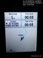
Proof. @52.4339,1.4379

Achievements
Sourcerer earned the Midnight Geohash achievement
|
{{Sourcerer_links
 | prev = 2015-12-05 52 1
 | curr = 2015-12-06 52 1
 | next = 2015-12-07 52 0
 | date = 2015-12-06