Difference between revisions of "2015-12-25 53 -1"
imported>Sourcerer m (Hash-mas dinner. [http://www.openstreetmap.org/?lat=52.99082110&lon=-2.21886350&zoom=16&layers=B000FTF @52.9908,-2.2189]) |
imported>FippeBot m (Location) |
||
| (4 intermediate revisions by one other user not shown) | |||
| Line 30: | Line 30: | ||
There was a bit of good luck. I could follow a police van for a useful distance. The other drivers, sometimes ill mannered and even dangerous were all well behaved for a change. The temperature dropped while crossing passes in the Derbyshire Peak District. There was a lay-by to park. | There was a bit of good luck. I could follow a police van for a useful distance. The other drivers, sometimes ill mannered and even dangerous were all well behaved for a change. The temperature dropped while crossing passes in the Derbyshire Peak District. There was a lay-by to park. | ||
| − | The walk started in a valley and ran parallel with a disused railway converted into the Tissington Trail footpath. Next there was a gate into the sheep field. There was a hill to climb. This was a novelty as my home graticule is all low lying. After my cardiovascular health scare last September, I was pleased to sail up the slope without any problems. There was a second, open gate and the hashpoint was in the middle of the top field. On the higher ground there was an icy wind at 1.5C. My proof photo was three minutes early. My arrival upload was bang on midnight. | + | The walk started in a valley and ran parallel with a disused railway converted into the Tissington Trail footpath. Next there was a gate into the sheep field. There was a hill to climb. This was a novelty as my home graticule is all low lying. After my cardiovascular health scare last September, I was pleased to sail up the slope without any problems, avoiding the rocky outcrop. There was a second, open gate and the hashpoint was in the middle of the top field. On the higher ground there was an icy wind at 1.5C, altitude 340 metres. My proof photo was three minutes early. My arrival upload was bang on midnight. |
The sheep ignored me on the way up. Coming back down, they just walked slowly aside not looking too bothered. Back in the valley a grass frost was forming. | The sheep ignored me on the way up. Coming back down, they just walked slowly aside not looking too bothered. Back in the valley a grass frost was forming. | ||
<div style="clear:both;"></div> | <div style="clear:both;"></div> | ||
| + | |||
== Photos == | == Photos == | ||
The après hash party. | The après hash party. | ||
| Line 40: | Line 41: | ||
<gallery> | <gallery> | ||
Image:2015-12-25_53_-1_Sourcerer_1451001429249.jpg | Proof. [http://www.openstreetmap.org/?lat=53.11057627&lon=-1.76197529&zoom=16&layers=B000FTF @53.1106,-1.7620] | Image:2015-12-25_53_-1_Sourcerer_1451001429249.jpg | Proof. [http://www.openstreetmap.org/?lat=53.11057627&lon=-1.76197529&zoom=16&layers=B000FTF @53.1106,-1.7620] | ||
| − | Image:2015-12-25 53 -1 Sourcerer.jpg | | + | Image:2015-12-25 53 -1 Sourcerer.jpg | Google Earth Track Zoomed |
| − | Image:2015-12-24 53 -2 Sourcerer.jpg | | + | Image:2015-12-24 53 -2 Sourcerer.jpg | Google Earth Track |
Image:2015-12-25_53_-1_Sourcerer_1451052706084.jpg | Hash-mas dinner. [http://www.openstreetmap.org/?lat=52.99082110&lon=-2.21886350&zoom=16&layers=B000FTF @52.9908,-2.2189] | Image:2015-12-25_53_-1_Sourcerer_1451052706084.jpg | Hash-mas dinner. [http://www.openstreetmap.org/?lat=52.99082110&lon=-2.21886350&zoom=16&layers=B000FTF @52.9908,-2.2189] | ||
| Line 66: | Line 67: | ||
| prev = 2015-12-24 53 -2 | | prev = 2015-12-24 53 -2 | ||
| curr = 2015-12-25 53 -1 | | curr = 2015-12-25 53 -1 | ||
| − | | next = 2015-12-27 52 - | + | | next = 2015-12-27 52 -0 |
| date = 2015-12-25 | | date = 2015-12-25 | ||
}} | }} | ||
| Line 73: | Line 74: | ||
[[Category:Expeditions with photos]] | [[Category:Expeditions with photos]] | ||
[[Category:Coordinates reached]] | [[Category:Coordinates reached]] | ||
| + | {{location|GB|ENG|DBY}} | ||
Latest revision as of 06:15, 15 August 2019

| Fri 25 Dec 2015 in Sheffield, UK: 53.1105637, -1.7620074 geohashing.info google osm bing/os kml crox |
Location
In a field between Newhaven and Alsop en le Dale, north of the A515 in a sheep pasture, Derbyshire, UK.
Participants
Plans
Expedition two of two spanning Christmas night.
2015-12-24 53 -2 - 2015-12-25 53 -1 - ETA 00:00.
This is my scientific paganism celebration of the winter solstice full moon (almost as this is 11 hours early). The true full moon will be round the back of the earth relative to the pub in Staffordshire, where the true celebrations will be held. The next Christmas-day full moon is in 2034 so this is a bit special.
Expedition
- Arrived and Happy Christmas! -- Sourcerer (talk) @53.0191,-1.7320 00:00, 25 December 2015 (GMT)
There was a bit of good luck. I could follow a police van for a useful distance. The other drivers, sometimes ill mannered and even dangerous were all well behaved for a change. The temperature dropped while crossing passes in the Derbyshire Peak District. There was a lay-by to park.
The walk started in a valley and ran parallel with a disused railway converted into the Tissington Trail footpath. Next there was a gate into the sheep field. There was a hill to climb. This was a novelty as my home graticule is all low lying. After my cardiovascular health scare last September, I was pleased to sail up the slope without any problems, avoiding the rocky outcrop. There was a second, open gate and the hashpoint was in the middle of the top field. On the higher ground there was an icy wind at 1.5C, altitude 340 metres. My proof photo was three minutes early. My arrival upload was bang on midnight.
The sheep ignored me on the way up. Coming back down, they just walked slowly aside not looking too bothered. Back in the valley a grass frost was forming.
Photos
The après hash party.

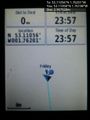
Proof. @53.1106,-1.7620
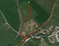
Google Earth Track Zoomed
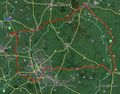
Google Earth Track
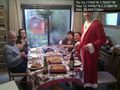
Hash-mas dinner. @52.9908,-2.2189


Achievements
Sourcerer earned the Midnight Geohash achievement
|

Expeditions and Plans
| 2015-12-25 | ||
|---|---|---|
| Kenosha, Wisconsin | meta-alt | On a road in Winnetka, IL, by the Skokie Lagoons. |
| Sheffield, United Kingdom | Sourcerer | In a field between Newhaven and Alsop en le Dale, north of the A515 in a sh... |
Sourcerer's Expedition Links
2015-12-24 53 -2 - 2015-12-25 53 -1 - 2015-12-27 52 -0 - KML file download of Sourcerer's expeditions for use with Google Earth.