Difference between revisions of "2015-12-29 50 7"
imported>Burgman (Created page with "{{meetup graticule | map=<map lat="50" lon="7" date="2015-12-29" /> | lat=50 | lon=7 | date=2015-12-29 | graticule_name=Bonn | graticule_link=Bonn, Germany}} == Location == A...") |
imported>FippeBot m (Location) |
||
| (One intermediate revision by one other user not shown) | |||
| Line 31: | Line 31: | ||
== Photos == | == Photos == | ||
<gallery> | <gallery> | ||
| − | + | File:20151229_50-7-01.jpg|Proof 1 | |
| + | File:20151229_50-7-02.jpg|Proof 2 | ||
| + | File:20151229_50-7-03.jpg|Near the hash, photo taken from the pole, grinning inside the hood | ||
| + | File:20151229_50-7-04.jpg|Poster placed onto the pole | ||
| + | File:20151229_50-7-05.jpg|In the background the golfers are approaching | ||
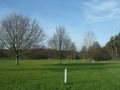
| + | File:20151229_50-7-06.jpg|The poles to the right are limiting the golf course | ||
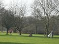
| + | File:20151229_50-7-07.jpg|Playing golf on an open meadow | ||
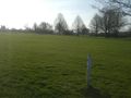
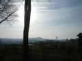
| + | File:20151229_50-7-08.jpg|The view to the south, to Rott | ||
| + | File:20151229_50-7-09.jpg|Now here come the bonus pictures, starting with this overgrown house | ||
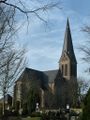
| + | File:20151229_50-7-10.jpg|Strange trees at the church | ||
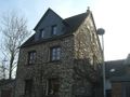
| + | File:20151229_50-7-11.jpg|An old, idyllic "Fachwerkhaus" (Tudor style house) | ||
| + | File:20151229_50-7-12.jpg|More Fachwerk on the main street... | ||
| + | File:20151229_50-7-13.jpg|...and narrow alleys | ||
| + | File:20151229_50-7-14.jpg|Converging lines due to the wide angle | ||
| + | File:20151229_50-7-15.jpg|Behind the church lies a small graveyard | ||
| + | File:20151229_50-7-16.jpg|The graves are mostly from the 20th century | ||
| + | File:20151229_50-7-17.jpg|Just like a postcard | ||
| + | File:20151229_50-7-18.jpg|One more postcard | ||
| + | File:20151229_50-7-19.jpg|The view to southwest | ||
| + | File:20151229_50-7-20.jpg|All candidates for the Coffin Potato Achievement | ||
</gallery> | </gallery> | ||
| Line 37: | Line 56: | ||
[[Category:Expeditions with photos]] | [[Category:Expeditions with photos]] | ||
[[Category:Coordinates reached]] | [[Category:Coordinates reached]] | ||
| + | {{location|DE|NW|SU}} | ||
Latest revision as of 06:18, 15 August 2019
| Tue 29 Dec 2015 in Bonn: 50.7548441, 7.2626942 geohashing.info google osm bing/os kml crox |
Contents
Location
A meadow between Geistingen and Rott, near Hennef.
Participants
Plans
According to the map the hash was on a meadow with a nameless street on the right side and a brook called Flutgraben on the left side right away. Seemed very easy. The temperature was at 8°C.
Expedition
Not much to say
Okay, it was very easy. When I got out of the car I was 150 m away from the hash, and there were no fences in between. (Based on my experience the day before and in Lohmar, I had suspected fences... again.) But so I was able to walk to the hash unhindered.
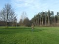
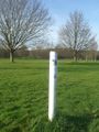
Just at the hash stood a white wooden pole, about 3 ft high. Had some determined geohasher put it here? But no, there were some other similar poles to see in the distance, forming a line. While I made my pictures, some people appeared playing golf. This was a golfing area, and the poles marked its border.
Nevertheless, I placed a poster on the pole of the perfect place.
Later I verified on the map that there was a golf club in the neighborhood just about 2000 ft afar.
But something to see
For the hash was so easy to reach, I pondered what I could do more here. On the last kilometer towards the hash I had passed the village Rott, which has some picturesque buildings. So I went there and took some photos to share them with you. For my part, reading the expedition reports of other geohashers, combined with their pictures of (strange places in) foreign countries, is part of the fun of geohashing. Maybe you like what you see here.
Photos

Proof 1
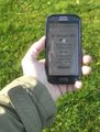
Proof 2
Near the hash, photo taken from the pole, grinning inside the hood
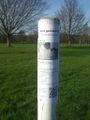
Poster placed onto the pole
In the background the golfers are approaching
The poles to the right are limiting the golf course
Playing golf on an open meadow
The view to the south, to Rott
Now here come the bonus pictures, starting with this overgrown house
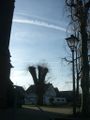
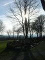
Strange trees at the church
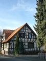
An old, idyllic "Fachwerkhaus" (Tudor style house)
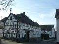
More Fachwerk on the main street...
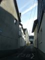
...and narrow alleys
Converging lines due to the wide angle
Behind the church lies a small graveyard
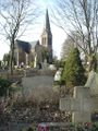
The graves are mostly from the 20th century
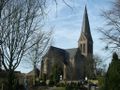
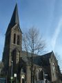
Just like a postcard
One more postcard
The view to southwest
All candidates for the Coffin Potato Achievement


